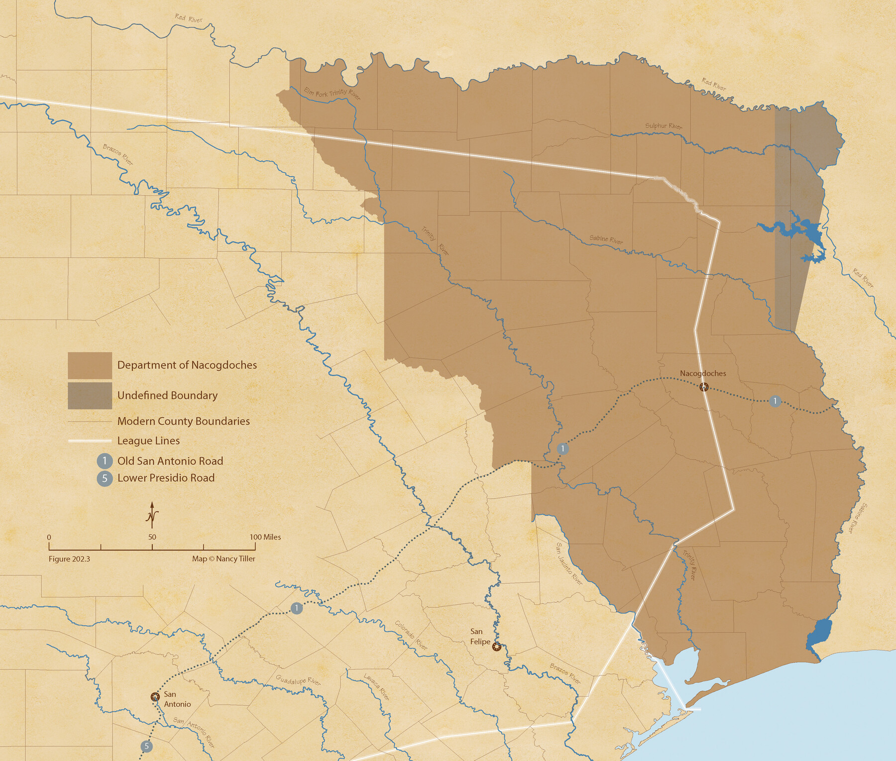
The Mexican Department of Nacogdoches. On the Eve of Texas Independence, 1836
Figure No. 202.3 from 'A Boundary Atlas of Texas, 1821-1845' by Jim Tiller
-
Map/Doc
95974
-
Collection
Nancy and Jim Tiller Digital Collection
-
Object Dates
2020/1/1 (Creation Date)
-
People and Organizations
Jim Tiller (Author)
Nancy Tiller (Cartographer)
Gang Gong (GIS Professional)
-
Subjects
Atlas Mexican Texas Texas Boundaries
-
Height x Width
18.4 x 21.7 inches
46.7 x 55.1 cm
-
Medium
digital image
-
Comments
To purchase a digital PDF copy of "A Boundary Atlas of Texas, 1821-1845" see 96437.
Part of: Nancy and Jim Tiller Digital Collection
The Nashville Association/Company Empresario Colony. October 15, 1827

Print $20.00
The Nashville Association/Company Empresario Colony. October 15, 1827
2020
Size 14.7 x 21.7 inches
Map/Doc 96001
Wavell Empresario Colony. Proposed, March 9, 1826

Print $20.00
Wavell Empresario Colony. Proposed, March 9, 1826
2020
Size 16.0 x 21.7 inches
Map/Doc 96009
The Republic County of Red River. December 29, 1845

Print $20.00
The Republic County of Red River. December 29, 1845
2020
Size 21.0 x 21.7 inches
Map/Doc 96255
From Citizens of Nacogdoches County Living East of the Trinity River and Along the Old San Antonio Road for the Creation of a New County (Unnamed), April 22, 1837

Print $20.00
From Citizens of Nacogdoches County Living East of the Trinity River and Along the Old San Antonio Road for the Creation of a New County (Unnamed), April 22, 1837
2020
Size 19.9 x 21.7 inches
Map/Doc 96374
The Chief Justice County of Washington. Undated

Print $20.00
The Chief Justice County of Washington. Undated
2020
Size 13.0 x 21.7 inches
Map/Doc 96077
The Mexican Municipality of Gonzales. April 1834

Print $20.00
The Mexican Municipality of Gonzales. April 1834
2020
Size 20.4 x 21.7 inches
Map/Doc 96021
The Judicial District/County of Lavaca. Abolished, Spring 1842

Print $20.00
The Judicial District/County of Lavaca. Abolished, Spring 1842
2020
Size 14.6 x 21.7 inches
Map/Doc 96332
The Republic County of Houston. Spring 1842

Print $20.00
The Republic County of Houston. Spring 1842
2020
Size 19.7 x 21.8 inches
Map/Doc 96182
The Republic County of San Patricio. December 2, 1841

Print $20.00
The Republic County of San Patricio. December 2, 1841
2020
Size 22.2 x 21.7 inches
Map/Doc 96277
The Mexican Department of Bexar. May 6, 1833

Print $20.00
The Mexican Department of Bexar. May 6, 1833
2020
Size 16.0 x 21.6 inches
Map/Doc 95969
Dominguez Empresario Colony. February 6, 1829

Print $20.00
Dominguez Empresario Colony. February 6, 1829
2020
Size 17.2 x 21.7 inches
Map/Doc 95992
The Republic County of Harrison. June 24, 1841

Print $20.00
The Republic County of Harrison. June 24, 1841
2020
Size 18.6 x 21.7 inches
Map/Doc 96171
You may also like
Reagan County Working Sketch 11

Print $20.00
- Digital $50.00
Reagan County Working Sketch 11
1943
Size 19.4 x 20.9 inches
Map/Doc 71851
Harrison County Rolled Sketch 10

Print $20.00
- Digital $50.00
Harrison County Rolled Sketch 10
1956
Size 33.6 x 26.1 inches
Map/Doc 6153
Brewster County Rolled Sketch 82

Print $20.00
- Digital $50.00
Brewster County Rolled Sketch 82
1945
Size 20.3 x 23.3 inches
Map/Doc 5245
Working Sketch in Lynn County

Print $20.00
- Digital $50.00
Working Sketch in Lynn County
1921
Size 15.1 x 18.9 inches
Map/Doc 91343
Crane County Rolled Sketch 17

Print $20.00
- Digital $50.00
Crane County Rolled Sketch 17
1926
Size 20.3 x 33.8 inches
Map/Doc 5576
[Surveys in the Jefferson District along Big Sandy Creek]
![100, [Surveys in the Jefferson District along Big Sandy Creek], General Map Collection](https://historictexasmaps.com/wmedia_w700/maps/100.tif.jpg)
Print $2.00
- Digital $50.00
[Surveys in the Jefferson District along Big Sandy Creek]
1841
Size 9.5 x 8.1 inches
Map/Doc 100
Matagorda County NRC Article 33.136 Sketch 2

Print $26.00
- Digital $50.00
Matagorda County NRC Article 33.136 Sketch 2
2005
Size 22.1 x 34.8 inches
Map/Doc 83395
The Republic of Texas, Defined, December 19, 1836

Print $20.00
The Republic of Texas, Defined, December 19, 1836
2020
Size 24.6 x 21.7 inches
Map/Doc 96036
San Jacinto River, Water Sheds of the San Jacinto River and Buffalo Bayou

Print $4.00
- Digital $50.00
San Jacinto River, Water Sheds of the San Jacinto River and Buffalo Bayou
Size 28.8 x 20.0 inches
Map/Doc 65149
Flight Mission No. DAG-21K, Frame 90, Matagorda County

Print $20.00
- Digital $50.00
Flight Mission No. DAG-21K, Frame 90, Matagorda County
1952
Size 18.5 x 22.2 inches
Map/Doc 86419
Travis County Sketch File 54

Print $20.00
- Digital $50.00
Travis County Sketch File 54
1945
Size 23.0 x 16.5 inches
Map/Doc 12470
Flight Mission No. DQN-1K, Frame 28, Calhoun County

Print $20.00
- Digital $50.00
Flight Mission No. DQN-1K, Frame 28, Calhoun County
1953
Size 18.5 x 22.3 inches
Map/Doc 84133