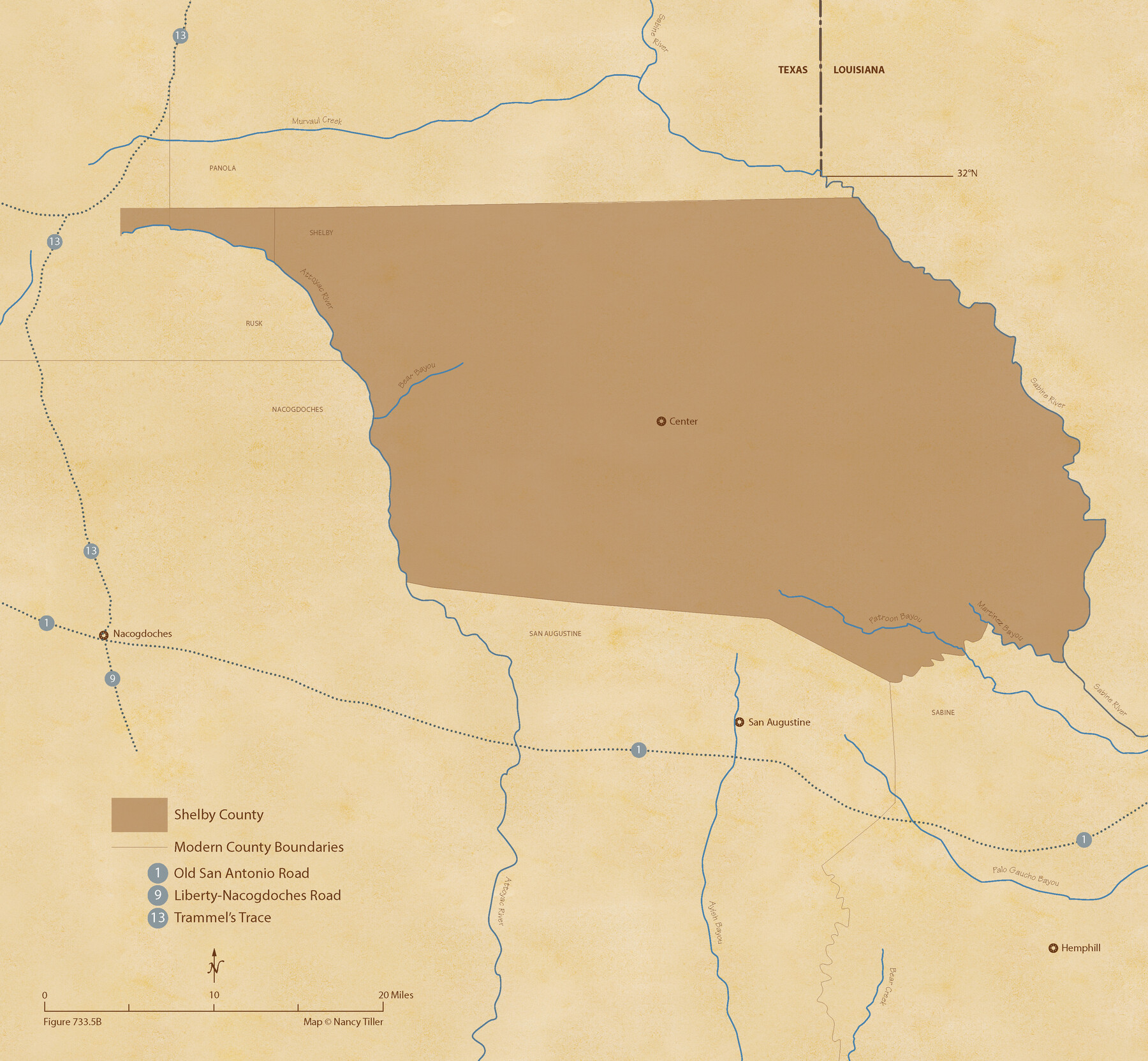
The Republic County of Shelby. Spring 1842
Figure No. 733.5 from 'A Boundary Atlas of Texas, 1821-1845' by Jim Tiller
-
Map/Doc
96284
-
Collection
Nancy and Jim Tiller Digital Collection
-
Object Dates
2020/1/1 (Creation Date)
-
People and Organizations
Jim Tiller (Author)
Nancy Tiller (Cartographer)
Gang Gong (GIS Professional)
-
Counties
Shelby
-
Subjects
Atlas County Republic of Texas Texas Boundaries
-
Height x Width
20.0 x 21.7 inches
50.8 x 55.1 cm
-
Medium
digital image
-
Comments
To purchase a digital PDF copy of "A Boundary Atlas of Texas, 1821-1845" see 96437.
Part of: Nancy and Jim Tiller Digital Collection
The Republic County of Goliad. Proposed, Late Fall 1837

Print $20.00
The Republic County of Goliad. Proposed, Late Fall 1837
2020
Size 15.1 x 21.7 inches
Map/Doc 96147
The Mexican Department of Brazos. Created, March 18, 1834

Print $20.00
The Mexican Department of Brazos. Created, March 18, 1834
2020
Size 19.7 x 21.7 inches
Map/Doc 95975
The Republic County of Milam. January 15, 1842

Print $20.00
The Republic County of Milam. January 15, 1842
2020
Size 17.4 x 21.6 inches
Map/Doc 96230
Zavala Empresario Colony. March 12, 1829

Print $20.00
Zavala Empresario Colony. March 12, 1829
2020
Size 24.7 x 21.7 inches
Map/Doc 96012
DeWitt Empresario Colony. April 15, 1825

Print $20.00
DeWitt Empresario Colony. April 15, 1825
2020
Size 18.1 x 21.7 inches
Map/Doc 95991
From Citizens of Nacogdoches County to Redefine the Boundaries of Nacogdoches County, December 2, 1841

Print $20.00
From Citizens of Nacogdoches County to Redefine the Boundaries of Nacogdoches County, December 2, 1841
2020
Size 22.5 x 21.7 inches
Map/Doc 96395
The Judicial District/County of Spring Creek. Abolished, Spring 1842

Print $20.00
The Judicial District/County of Spring Creek. Abolished, Spring 1842
2020
Size 15.7 x 21.7 inches
Map/Doc 96349
The Land Offices. No. 8, Mina, December 22, 1836

Print $20.00
The Land Offices. No. 8, Mina, December 22, 1836
2020
Size 19.9 x 21.7 inches
Map/Doc 96421
The Republic County of Rusk. Created, January 16, 1843

Print $20.00
The Republic County of Rusk. Created, January 16, 1843
2020
Size 19.1 x 21.7 inches
Map/Doc 96265
The Republic County of Galveston. December 16, 1839

Print $20.00
The Republic County of Galveston. December 16, 1839
2020
Size 14.7 x 21.9 inches
Map/Doc 96144
The Judicial District/County of Hamilton. Abolished, Spring 1842

Print $20.00
The Judicial District/County of Hamilton. Abolished, Spring 1842
2020
Size 14.9 x 21.7 inches
Map/Doc 96330
The Republic County of Goliad. December 29, 1845

Print $20.00
The Republic County of Goliad. December 29, 1845
2020
Size 17.5 x 21.7 inches
Map/Doc 96152
You may also like
Flight Mission No. DQN-5K, Frame 32, Calhoun County

Print $20.00
- Digital $50.00
Flight Mission No. DQN-5K, Frame 32, Calhoun County
1953
Size 16.5 x 16.3 inches
Map/Doc 84383
Midland County Rolled Sketch 14

Print $20.00
- Digital $50.00
Midland County Rolled Sketch 14
1996
Size 21.3 x 26.7 inches
Map/Doc 6769
Louisiana and Texas Intracoastal Waterway

Print $20.00
- Digital $50.00
Louisiana and Texas Intracoastal Waterway
1929
Size 13.7 x 19.0 inches
Map/Doc 83344
[Plat Showing Colorado, Upshur & Travis County School Land and Surrounding Area in Baylor & Throckmorton Counties, Texas]
![75790, [Plat Showing Colorado, Upshur & Travis County School Land and Surrounding Area in Baylor & Throckmorton Counties, Texas], Maddox Collection](https://historictexasmaps.com/wmedia_w700/maps/75790.tif.jpg)
Print $20.00
- Digital $50.00
[Plat Showing Colorado, Upshur & Travis County School Land and Surrounding Area in Baylor & Throckmorton Counties, Texas]
1889
Size 15.8 x 20.5 inches
Map/Doc 75790
America sive novvs orbis respectv evropaeorvm inferior globi terrestris pars 1596

Print $20.00
- Digital $50.00
America sive novvs orbis respectv evropaeorvm inferior globi terrestris pars 1596
1596
Size 14.7 x 18.1 inches
Map/Doc 93809
Chambers County Sketch File 4a

Print $19.00
- Digital $50.00
Chambers County Sketch File 4a
1839
Size 11.4 x 17.8 inches
Map/Doc 17523
Anderson County Sketch File 11a

Print $6.00
- Digital $50.00
Anderson County Sketch File 11a
1854
Size 8.2 x 8.2 inches
Map/Doc 12768
Leon County Rolled Sketch 28

Print $20.00
- Digital $50.00
Leon County Rolled Sketch 28
1993
Size 35.8 x 46.6 inches
Map/Doc 9438
Tom Green County

Print $40.00
- Digital $50.00
Tom Green County
Size 43.6 x 111.2 inches
Map/Doc 82058
Crane County Working Sketch 25

Print $20.00
- Digital $50.00
Crane County Working Sketch 25
1969
Size 33.0 x 26.3 inches
Map/Doc 68302
Young County Sketch File 20

Print $20.00
- Digital $50.00
Young County Sketch File 20
1922
Size 27.4 x 23.9 inches
Map/Doc 12714
[Area between H. & T. C. Block 34, PSL Block B19 and University Lands Block 16]
![91957, [Area between H. & T. C. Block 34, PSL Block B19 and University Lands Block 16], Twichell Survey Records](https://historictexasmaps.com/wmedia_w700/maps/91957-1.tif.jpg)
Print $20.00
- Digital $50.00
[Area between H. & T. C. Block 34, PSL Block B19 and University Lands Block 16]
1929
Size 40.4 x 29.3 inches
Map/Doc 91957