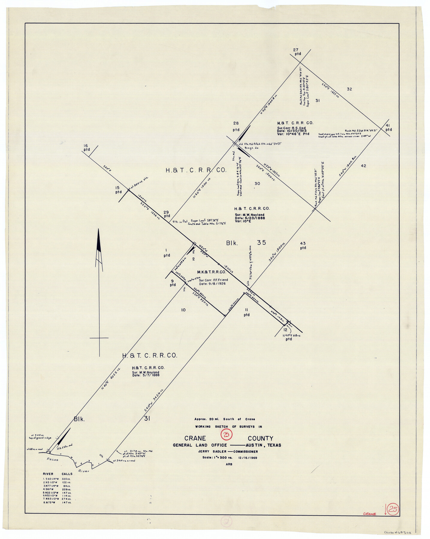
Crane County Working Sketch 25
-
Map/Doc
68302
-
Collection
General Map Collection
-
Object Dates
12/16/1969 (Creation Date)
-
Counties
Crane
-
Subjects
Surveying Working Sketch
-
Height x Width
33.0 x 26.3 inches
83.8 x 66.8 cm
-
Scale
1" = 300 varas
Part of: General Map Collection
Lamar County Working Sketch 4

Print $20.00
- Digital $50.00
Lamar County Working Sketch 4
1920
Size 14.4 x 25.1 inches
Map/Doc 70265
San Antonio & Aransas Pass

Print $40.00
- Digital $50.00
San Antonio & Aransas Pass
Size 30.4 x 81.6 inches
Map/Doc 64634
Loving County Rolled Sketch 5

Print $40.00
- Digital $50.00
Loving County Rolled Sketch 5
1952
Size 146.0 x 14.2 inches
Map/Doc 9467
Hutchinson County Sketch File 53

Print $2.00
- Digital $50.00
Hutchinson County Sketch File 53
2000
Size 11.2 x 8.8 inches
Map/Doc 27455
Flight Mission No. BRA-8M, Frame 83, Jefferson County

Print $20.00
- Digital $50.00
Flight Mission No. BRA-8M, Frame 83, Jefferson County
1953
Size 15.8 x 15.7 inches
Map/Doc 85603
Flight Mission No. DAG-17K, Frame 127, Matagorda County

Print $20.00
- Digital $50.00
Flight Mission No. DAG-17K, Frame 127, Matagorda County
1952
Size 18.6 x 18.7 inches
Map/Doc 86347
Jefferson County Rolled Sketch 22

Print $92.00
- Digital $50.00
Jefferson County Rolled Sketch 22
1936
Size 20.4 x 73.1 inches
Map/Doc 9287
East Part of Edwards County

Print $40.00
- Digital $50.00
East Part of Edwards County
1975
Size 56.3 x 41.1 inches
Map/Doc 95488
Wood County Working Sketch 4

Print $20.00
- Digital $50.00
Wood County Working Sketch 4
1941
Size 21.0 x 28.3 inches
Map/Doc 62004
Menard County Working Sketch 22

Print $20.00
- Digital $50.00
Menard County Working Sketch 22
1950
Size 31.7 x 38.7 inches
Map/Doc 70969
Flight Mission No. DCL-6C, Frame 22, Kenedy County

Print $20.00
- Digital $50.00
Flight Mission No. DCL-6C, Frame 22, Kenedy County
1943
Size 18.6 x 22.3 inches
Map/Doc 85879
Map of Ellis County

Print $20.00
- Digital $50.00
Map of Ellis County
1857
Size 20.2 x 28.1 inches
Map/Doc 3510
You may also like
Sunny San Antonio - The Winter Playground of America

Sunny San Antonio - The Winter Playground of America
1920
Size 9.4 x 7.9 inches
Map/Doc 97040
Hudspeth County Rolled Sketch 30

Print $20.00
- Digital $50.00
Hudspeth County Rolled Sketch 30
1924
Size 36.0 x 47.3 inches
Map/Doc 9210
Presidio County Sketch File 84 1/2

Print $38.00
- Digital $50.00
Presidio County Sketch File 84 1/2
1949
Size 9.0 x 14.5 inches
Map/Doc 34726
Galveston County NRC Article 33.136 Sketch 60

Print $88.00
- Digital $50.00
Galveston County NRC Article 33.136 Sketch 60
2009
Size 24.0 x 36.0 inches
Map/Doc 89263
Dimmit County Sketch File 21

Print $16.00
- Digital $50.00
Dimmit County Sketch File 21
1898
Size 14.4 x 8.8 inches
Map/Doc 21115
Wichita County Sketch File 35

Print $8.00
- Digital $50.00
Wichita County Sketch File 35
1950
Size 14.3 x 8.5 inches
Map/Doc 40157
Chambers County Sketch File 40

Print $35.00
- Digital $50.00
Chambers County Sketch File 40
1925
Size 14.0 x 8.5 inches
Map/Doc 17677
Map of Bowie County

Print $20.00
- Digital $50.00
Map of Bowie County
1884
Size 19.4 x 23.7 inches
Map/Doc 3319
Orange County Working Sketch 15

Print $20.00
- Digital $50.00
Orange County Working Sketch 15
1928
Size 19.3 x 24.6 inches
Map/Doc 71347
Travis County Appraisal District Plat Map 1_0100

Print $20.00
- Digital $50.00
Travis County Appraisal District Plat Map 1_0100
Size 21.6 x 26.4 inches
Map/Doc 94205
Culberson County Working Sketch 36

Print $20.00
- Digital $50.00
Culberson County Working Sketch 36
1964
Size 20.8 x 24.4 inches
Map/Doc 68489
English Field Notes of the Spanish Archives - Book J. Strode

English Field Notes of the Spanish Archives - Book J. Strode
1835
Map/Doc 96549