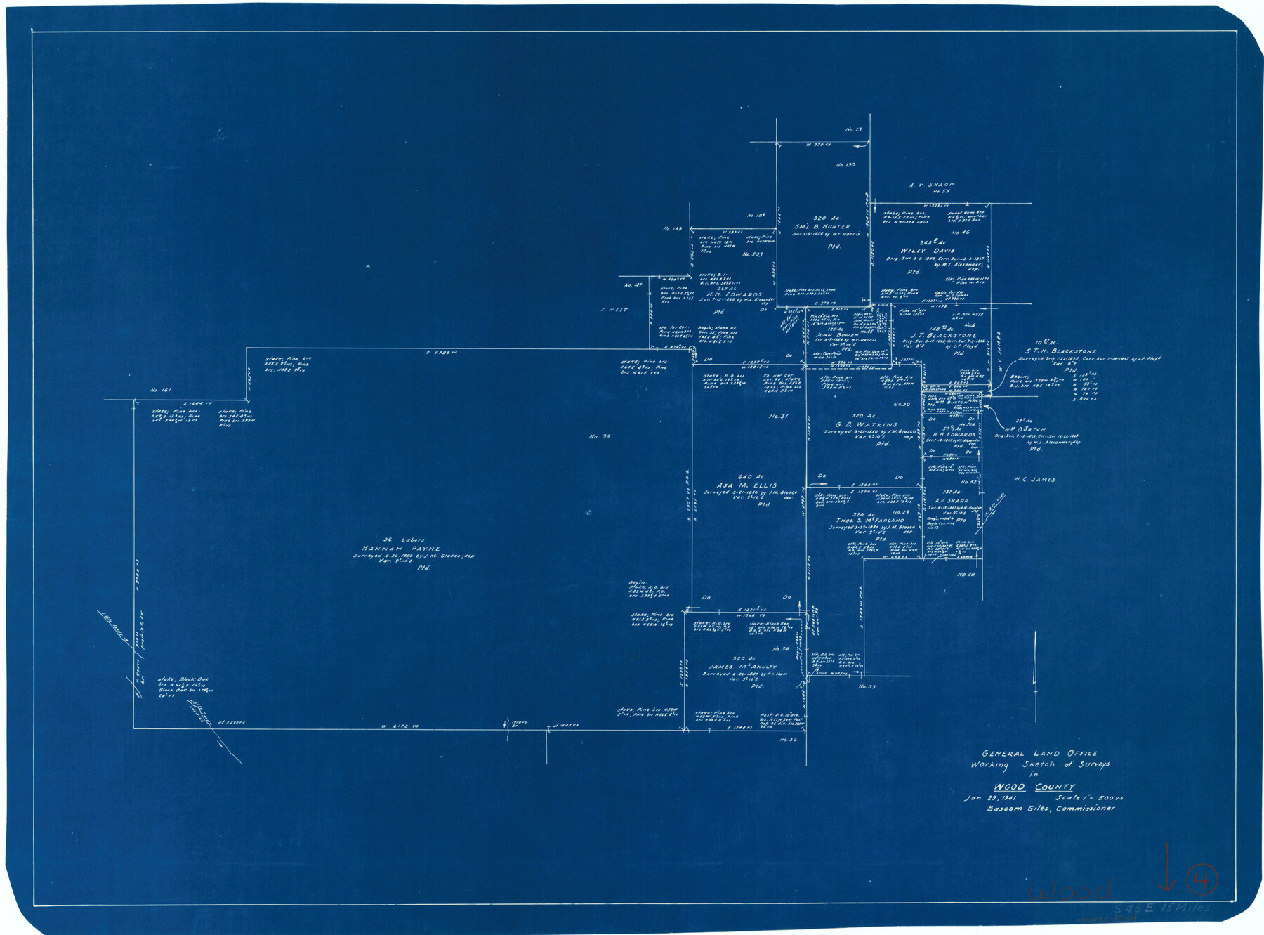
Wood County Working Sketch 4
-
Map/Doc
62004
-
Collection
General Map Collection
-
Object Dates
1/29/1941 (Creation Date)
-
Counties
Wood
-
Subjects
Surveying Working Sketch
-
Height x Width
21.0 x 28.3 inches
53.3 x 71.9 cm
-
Scale
1" = 500 varas
Part of: General Map Collection
Cochran County Sketch File 7

Print $10.00
- Digital $50.00
Cochran County Sketch File 7
1940
Size 11.2 x 8.6 inches
Map/Doc 18550
Montgomery County Working Sketch Graphic Index, Sheet 1 (Sketches 1 to 35)

Print $40.00
- Digital $50.00
Montgomery County Working Sketch Graphic Index, Sheet 1 (Sketches 1 to 35)
1943
Size 43.0 x 51.9 inches
Map/Doc 76646
Gregg County Sketch File 1G

Print $2.00
- Digital $50.00
Gregg County Sketch File 1G
Size 6.2 x 7.0 inches
Map/Doc 24549
Flight Mission No. DQO-8K, Frame 145, Galveston County

Print $20.00
- Digital $50.00
Flight Mission No. DQO-8K, Frame 145, Galveston County
1952
Size 18.6 x 22.5 inches
Map/Doc 85207
Reeves County Rolled Sketch 30

Print $20.00
- Digital $50.00
Reeves County Rolled Sketch 30
1988
Size 18.4 x 24.4 inches
Map/Doc 7499
Map of Wharton County

Print $40.00
- Digital $50.00
Map of Wharton County
1895
Size 48.2 x 53.8 inches
Map/Doc 82055
Cass County Sketch File 2

Print $4.00
- Digital $50.00
Cass County Sketch File 2
1849
Size 12.4 x 7.7 inches
Map/Doc 17394

Hall County Rolled Sketch D2

Print $20.00
- Digital $50.00
Hall County Rolled Sketch D2
Size 19.0 x 22.1 inches
Map/Doc 6055
Val Verde County Sketch File 35A

Print $18.00
- Digital $50.00
Val Verde County Sketch File 35A
1936
Size 4.4 x 7.4 inches
Map/Doc 39253
Delta County Sketch File 6

Print $20.00
- Digital $50.00
Delta County Sketch File 6
Size 18.3 x 22.4 inches
Map/Doc 11310
Corpus Christi Harbor

Print $40.00
- Digital $50.00
Corpus Christi Harbor
1972
Size 36.9 x 52.3 inches
Map/Doc 73477
You may also like
Township 2 North, Block 32]
![91211, Township 2 North, Block 32], Twichell Survey Records](https://historictexasmaps.com/wmedia_w700/maps/91211-1.tif.jpg)
Print $2.00
- Digital $50.00
Township 2 North, Block 32]
Size 9.0 x 13.7 inches
Map/Doc 91211
Coryell County Working Sketch 4

Print $20.00
- Digital $50.00
Coryell County Working Sketch 4
1929
Size 23.8 x 18.3 inches
Map/Doc 68211
Culberson County Sketch File 42

Print $14.00
- Digital $50.00
Culberson County Sketch File 42
1966
Size 14.2 x 8.7 inches
Map/Doc 20322
Rusk County Sketch File 37

Print $20.00
Rusk County Sketch File 37
1951
Size 23.3 x 26.2 inches
Map/Doc 12275
Baylor County Boundary File 14

Print $6.00
- Digital $50.00
Baylor County Boundary File 14
Size 11.1 x 8.6 inches
Map/Doc 50428
Loving County Sketch File 10

Print $2.00
- Digital $50.00
Loving County Sketch File 10
2016
Size 11.0 x 8.5 inches
Map/Doc 94115
Bandera County Working Sketch 8

Print $20.00
- Digital $50.00
Bandera County Working Sketch 8
1920
Size 16.6 x 20.8 inches
Map/Doc 67601
English Field Notes of the Spanish Archives - Book D

English Field Notes of the Spanish Archives - Book D
1835
Map/Doc 96542
Webb County Rolled Sketch 48

Print $20.00
- Digital $50.00
Webb County Rolled Sketch 48
1943
Size 20.1 x 37.3 inches
Map/Doc 8204
Wichita County Sketch File 7

Print $2.00
- Digital $50.00
Wichita County Sketch File 7
Size 7.5 x 13.9 inches
Map/Doc 40047
Hood County Working Sketch 27

Print $20.00
- Digital $50.00
Hood County Working Sketch 27
1995
Size 24.6 x 38.0 inches
Map/Doc 66221
Intracoastal Waterway - Galveston Bay to West Bay including Galveston Bay Entrance

Print $20.00
- Digital $50.00
Intracoastal Waterway - Galveston Bay to West Bay including Galveston Bay Entrance
1961
Size 26.7 x 38.7 inches
Map/Doc 69934