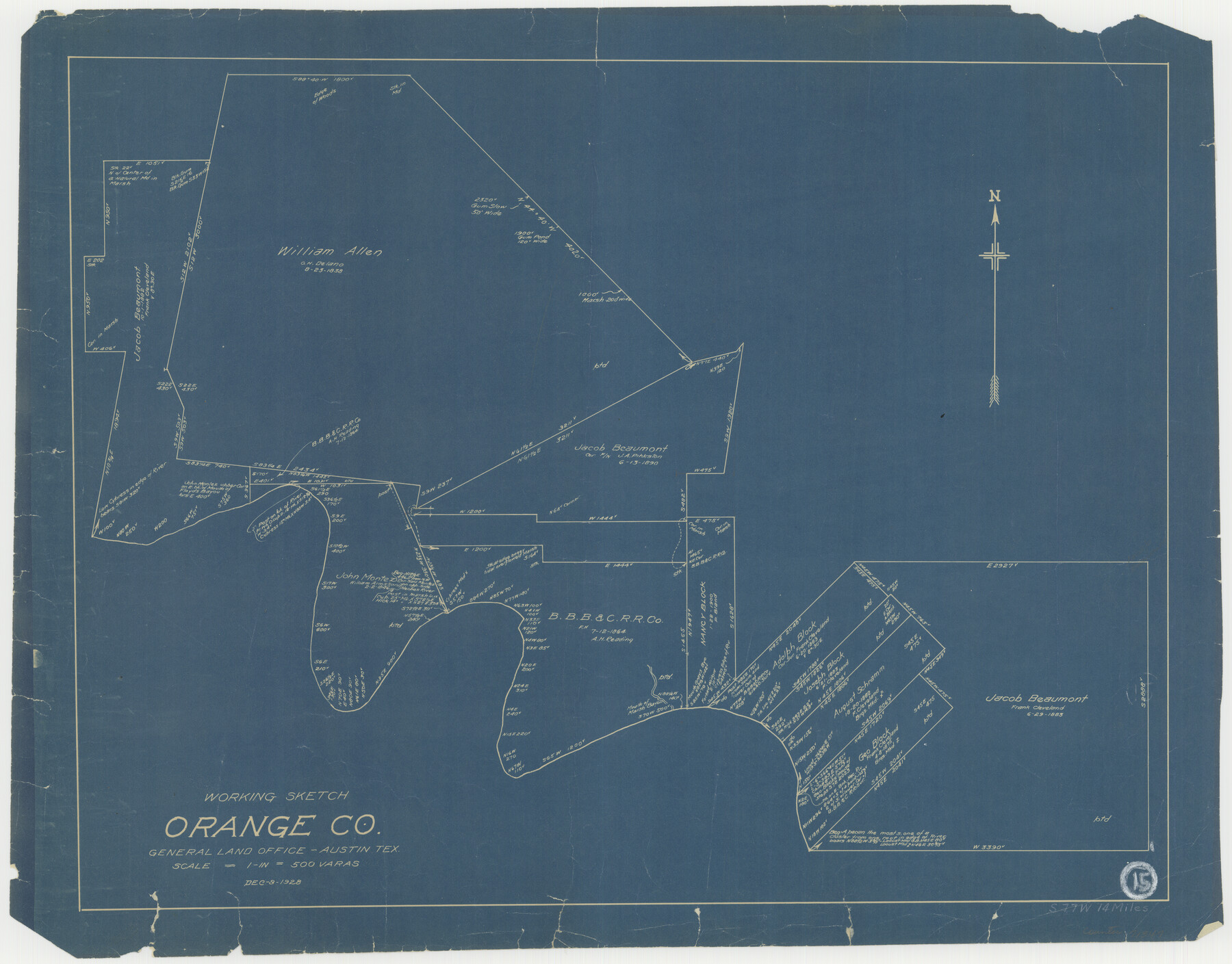
Orange County Working Sketch 15
-
Map/Doc
71347
-
Collection
General Map Collection
-
Object Dates
12/8/1928 (Creation Date)
-
Counties
Orange
-
Subjects
Surveying Working Sketch
-
Height x Width
19.3 x 24.6 inches
49.0 x 62.5 cm
-
Scale
1" = 500 varas
Part of: General Map Collection
A New Map of North America

Print $20.00
- Digital $50.00
A New Map of North America
1779
Size 18.5 x 22.2 inches
Map/Doc 95141
Right of Way and Track Map - Houston & Texas Central R.R. operated by the T. and N. O. R.R. Co. - Fort Worth Branch

Print $40.00
- Digital $50.00
Right of Way and Track Map - Houston & Texas Central R.R. operated by the T. and N. O. R.R. Co. - Fort Worth Branch
1918
Size 26.5 x 58.3 inches
Map/Doc 82861
Ellis County Sketch File 5

Print $4.00
- Digital $50.00
Ellis County Sketch File 5
Size 10.3 x 8.2 inches
Map/Doc 21834
[San Antonio & Aransas Pass Ry. from Lockhart to Caldwell-Gonzales County line]
![64259, [San Antonio & Aransas Pass Ry. from Lockhart to Caldwell-Gonzales County line], General Map Collection](https://historictexasmaps.com/wmedia_w700/maps/64259.tif.jpg)
Print $40.00
- Digital $50.00
[San Antonio & Aransas Pass Ry. from Lockhart to Caldwell-Gonzales County line]
1895
Size 53.6 x 15.1 inches
Map/Doc 64259
Cherokee County Sketch File 28

Print $6.00
- Digital $50.00
Cherokee County Sketch File 28
1916
Size 11.0 x 14.0 inches
Map/Doc 18173
Palo Pinto County Working Sketch Graphic Index

Print $20.00
- Digital $50.00
Palo Pinto County Working Sketch Graphic Index
1941
Map/Doc 76659
Official Map of the State of Texas to accompany the Statistical and Descriptive Work, "Resources, Soil and Climate of Texas"

Print $20.00
- Digital $50.00
Official Map of the State of Texas to accompany the Statistical and Descriptive Work, "Resources, Soil and Climate of Texas"
1882
Size 31.1 x 33.1 inches
Map/Doc 2134
Right of Way and Track Map, Houston & Texas Central R.R. operated by the T. and N. O. R.R., Fort Worth Branch

Print $40.00
- Digital $50.00
Right of Way and Track Map, Houston & Texas Central R.R. operated by the T. and N. O. R.R., Fort Worth Branch
1918
Size 31.6 x 57.2 inches
Map/Doc 64780
Kimble County Working Sketch 71

Print $20.00
- Digital $50.00
Kimble County Working Sketch 71
1965
Size 47.1 x 22.0 inches
Map/Doc 70139
Reagan County Working Sketch 13

Print $40.00
- Digital $50.00
Reagan County Working Sketch 13
1948
Size 23.8 x 50.8 inches
Map/Doc 71853
Prison Property, Walker County

Print $20.00
- Digital $50.00
Prison Property, Walker County
Size 32.6 x 22.7 inches
Map/Doc 94279
Hardeman County

Print $20.00
- Digital $50.00
Hardeman County
1935
Size 45.1 x 42.2 inches
Map/Doc 1848
You may also like
Flight Mission No. BRA-7M, Frame 18, Jefferson County

Print $20.00
- Digital $50.00
Flight Mission No. BRA-7M, Frame 18, Jefferson County
1953
Size 18.5 x 22.3 inches
Map/Doc 85469
Flight Mission No. DIX-7P, Frame 86, Aransas County

Print $20.00
- Digital $50.00
Flight Mission No. DIX-7P, Frame 86, Aransas County
1956
Size 18.7 x 22.5 inches
Map/Doc 83880
Matagorda Light to Aransas Pass

Print $20.00
- Digital $50.00
Matagorda Light to Aransas Pass
1957
Size 35.8 x 44.7 inches
Map/Doc 73395
Jones County Sketch File 1

Print $20.00
- Digital $50.00
Jones County Sketch File 1
1857
Size 17.8 x 30.3 inches
Map/Doc 11894
Dickens County Boundary File 3

Print $28.00
- Digital $50.00
Dickens County Boundary File 3
Size 14.1 x 8.8 inches
Map/Doc 52541
Sketch showing the Connnecting Lines run by Olliver Hedgcoxe for the Texan Emigration and Land Company connecting their Surveys made by them in Peters' Colony, Texas

Print $40.00
- Digital $50.00
Sketch showing the Connnecting Lines run by Olliver Hedgcoxe for the Texan Emigration and Land Company connecting their Surveys made by them in Peters' Colony, Texas
1854
Size 45.8 x 61.9 inches
Map/Doc 1969
Mapa de los Estados Unidos de Méjico, Segun lo organizado y definido por las varias actas del Congreso de dicha Republica: y construido por las mejores autoridades

Print $20.00
- Digital $50.00
Mapa de los Estados Unidos de Méjico, Segun lo organizado y definido por las varias actas del Congreso de dicha Republica: y construido por las mejores autoridades
1828
Size 29.1 x 41.6 inches
Map/Doc 93846
Crane County Rolled Sketch 14

Print $46.00
- Digital $50.00
Crane County Rolled Sketch 14
1935
Size 37.1 x 31.6 inches
Map/Doc 8680
Flight Mission No. BQR-12K, Frame 50, Brazoria County

Print $20.00
- Digital $50.00
Flight Mission No. BQR-12K, Frame 50, Brazoria County
1952
Size 18.7 x 22.4 inches
Map/Doc 84065
La Salle County Sketch File 12

Print $15.00
- Digital $50.00
La Salle County Sketch File 12
1877
Size 10.0 x 8.1 inches
Map/Doc 29470
[Plat of Location and Right of Way from El Paso, Tex. To New Mexico Line, Rio Grande and El Paso R. R.]
![64082, [Plat of Location and Right of Way from El Paso, Tex. To New Mexico Line, Rio Grande and El Paso R. R.], General Map Collection](https://historictexasmaps.com/wmedia_w700/maps/64082.tif.jpg)
Print $40.00
- Digital $50.00
[Plat of Location and Right of Way from El Paso, Tex. To New Mexico Line, Rio Grande and El Paso R. R.]
Size 23.8 x 122.6 inches
Map/Doc 64082
Williamson County Sketch File 5

Print $13.00
- Digital $50.00
Williamson County Sketch File 5
1847
Size 8.2 x 11.2 inches
Map/Doc 40306