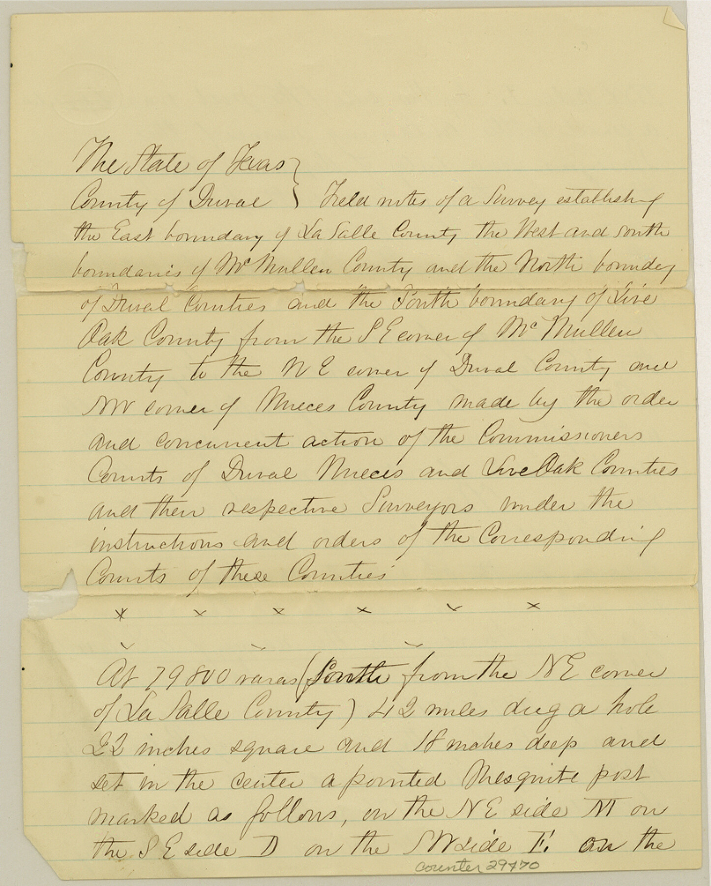
La Salle County Sketch File 12
[Letter protesting recording field notes known to be in conflict with superior surveys]
-
Map/Doc
29470
-
Collection
General Map Collection
-
Object Dates
1877/12/24 (Creation Date)
1878/3/29 (File Date)
1877/4/25 (Survey Date)
1877/5/18 (Survey Date)
1877/12/24 (Correspondence Date)
-
People and Organizations
Lafayette Caldwell (Surveyor/Engineer)
-
Counties
La Salle McMullen Duval Nueces Live Oak Encinal Webb
-
Subjects
Surveying Sketch File
-
Height x Width
10.0 x 8.1 inches
25.4 x 20.6 cm
-
Medium
paper, manuscript
-
Features
Steele's Ranch
Jarita Creek
Part of: General Map Collection
Uvalde County Rolled Sketch 5

Print $20.00
- Digital $50.00
Uvalde County Rolled Sketch 5
Size 38.0 x 42.6 inches
Map/Doc 10063
The Republic of Texas, March 2, 1836 - February 19, 1846

The Republic of Texas, March 2, 1836 - February 19, 1846
1972
Size 23.4 x 18.3 inches
Map/Doc 2109
Childress County

Print $20.00
- Digital $50.00
Childress County
1883
Size 20.8 x 19.0 inches
Map/Doc 3394
Lampasas County Working Sketch 6

Print $20.00
- Digital $50.00
Lampasas County Working Sketch 6
1950
Size 29.5 x 20.6 inches
Map/Doc 70283
Flight Mission No. BQR-9K, Frame 11, Brazoria County

Print $20.00
- Digital $50.00
Flight Mission No. BQR-9K, Frame 11, Brazoria County
1952
Size 18.7 x 22.4 inches
Map/Doc 84040
Matagorda County Sketch File 48

Print $108.00
- Digital $50.00
Matagorda County Sketch File 48
1998
Size 11.1 x 8.6 inches
Map/Doc 31009
Flight Mission No. DQN-2K, Frame 33, Calhoun County

Print $20.00
- Digital $50.00
Flight Mission No. DQN-2K, Frame 33, Calhoun County
1953
Size 18.6 x 22.2 inches
Map/Doc 84240
McMullen County Sketch File 36

Print $8.00
- Digital $50.00
McMullen County Sketch File 36
Size 4.8 x 8.2 inches
Map/Doc 31406
Stephens County Working Sketch 20

Print $20.00
- Digital $50.00
Stephens County Working Sketch 20
1972
Size 26.7 x 30.6 inches
Map/Doc 63963
Pecos County Rolled Sketch 181

Print $20.00
- Digital $50.00
Pecos County Rolled Sketch 181
1980
Size 18.4 x 18.7 inches
Map/Doc 7300
Flight Mission No. BRE-1P, Frame 57, Nueces County

Print $20.00
- Digital $50.00
Flight Mission No. BRE-1P, Frame 57, Nueces County
1956
Size 18.5 x 22.2 inches
Map/Doc 86646
Maps of Block 97, Borden & Scurry Counties

Print $40.00
- Digital $50.00
Maps of Block 97, Borden & Scurry Counties
Size 58.2 x 42.2 inches
Map/Doc 65691
You may also like
Right of Way and Track Map, the Missouri, Kansas and Texas Ry. of Texas - Henrietta Division

Print $20.00
- Digital $50.00
Right of Way and Track Map, the Missouri, Kansas and Texas Ry. of Texas - Henrietta Division
1918
Size 11.8 x 26.8 inches
Map/Doc 64762
Cottle County Working Sketch 1

Print $20.00
- Digital $50.00
Cottle County Working Sketch 1
1895
Size 27.0 x 21.7 inches
Map/Doc 68311
Galveston County NRC Article 33.136 Sketch 47

Print $24.00
- Digital $50.00
Galveston County NRC Article 33.136 Sketch 47
2006
Size 18.3 x 24.4 inches
Map/Doc 87504
Hardin County Sketch File 69

Print $20.00
- Digital $50.00
Hardin County Sketch File 69
1944
Size 25.1 x 22.0 inches
Map/Doc 11641
Flight Mission No. DQO-3K, Frame 16, Galveston County

Print $20.00
- Digital $50.00
Flight Mission No. DQO-3K, Frame 16, Galveston County
1952
Size 18.9 x 22.5 inches
Map/Doc 85057
Kent County Sketch File 6

Print $4.00
- Digital $50.00
Kent County Sketch File 6
1910
Size 8.3 x 7.0 inches
Map/Doc 28830
Frio County Working Sketch 11

Print $20.00
- Digital $50.00
Frio County Working Sketch 11
1952
Size 22.9 x 20.0 inches
Map/Doc 69285
Menard County Boundary File 4

Print $12.00
- Digital $50.00
Menard County Boundary File 4
Size 10.9 x 8.6 inches
Map/Doc 57076
Texas Panhandle North Boundary Line

Print $40.00
- Digital $50.00
Texas Panhandle North Boundary Line
1898
Size 13.4 x 125.2 inches
Map/Doc 1738
Baylor County Sketch File 16

Print $6.00
- Digital $50.00
Baylor County Sketch File 16
1879
Size 9.5 x 6.2 inches
Map/Doc 14186
Galveston Co.

Print $40.00
- Digital $50.00
Galveston Co.
1891
Size 38.5 x 53.8 inches
Map/Doc 66834
Hays County Working Sketch 4

Print $20.00
- Digital $50.00
Hays County Working Sketch 4
1928
Size 25.4 x 21.7 inches
Map/Doc 66078