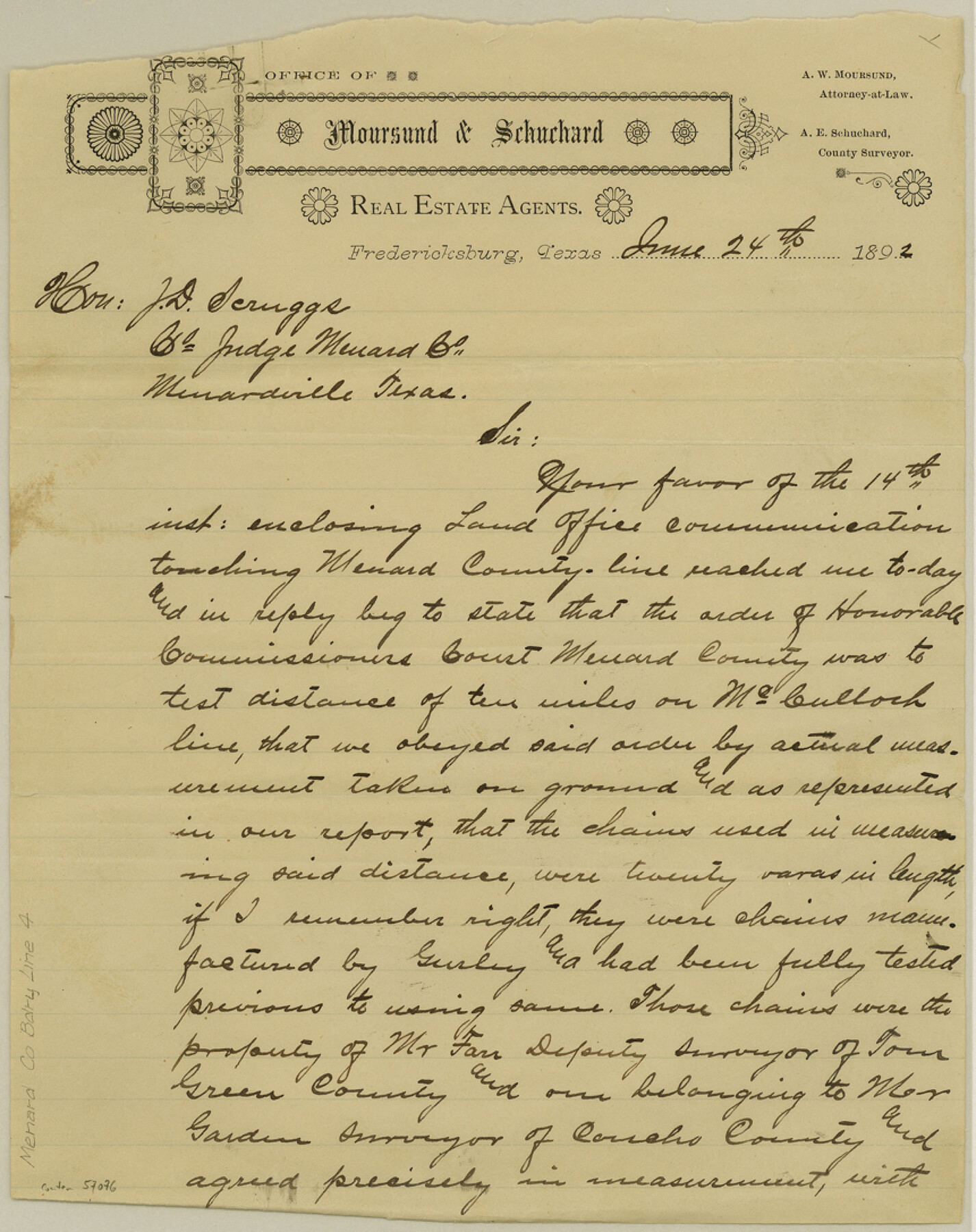
Menard County Boundary File 4
[Letter regarding Menard-McCulloch Boundary]
-
Map/Doc
57076
-
Collection
General Map Collection
-
Counties
Menard
-
Subjects
County Boundaries
-
Height x Width
10.9 x 8.6 inches
27.7 x 21.8 cm
Part of: General Map Collection
Crockett County Sketch File 94

Print $6.00
- Digital $50.00
Crockett County Sketch File 94
1940
Size 9.2 x 12.3 inches
Map/Doc 19950
Crosby County Sketch File 30

Print $4.00
- Digital $50.00
Crosby County Sketch File 30
1935
Size 11.4 x 7.4 inches
Map/Doc 20102
Titus County Working Sketch 7

Print $20.00
- Digital $50.00
Titus County Working Sketch 7
1970
Size 31.5 x 28.7 inches
Map/Doc 69368
Presidio County Rolled Sketch MS

Print $20.00
- Digital $50.00
Presidio County Rolled Sketch MS
Size 35.9 x 19.0 inches
Map/Doc 7412
Tom Green County Rolled Sketch 12A

Print $40.00
- Digital $50.00
Tom Green County Rolled Sketch 12A
1951
Size 42.9 x 50.4 inches
Map/Doc 10003
Middle Sulphur and South Sulphur Rivers, Horton Sheet

Print $20.00
- Digital $50.00
Middle Sulphur and South Sulphur Rivers, Horton Sheet
1925
Size 25.6 x 22.0 inches
Map/Doc 78330
Webb County Working Sketch 71

Print $40.00
- Digital $50.00
Webb County Working Sketch 71
1973
Size 46.1 x 95.8 inches
Map/Doc 72438
Montgomery County Rolled Sketch 42

Print $20.00
- Digital $50.00
Montgomery County Rolled Sketch 42
1939
Size 14.1 x 20.1 inches
Map/Doc 6818
Presidio County Working Sketch 65

Print $20.00
- Digital $50.00
Presidio County Working Sketch 65
1958
Size 31.1 x 26.3 inches
Map/Doc 71742
Map of Hopkins County

Print $20.00
- Digital $50.00
Map of Hopkins County
1853
Size 17.8 x 18.5 inches
Map/Doc 3680
Andrews County Working Sketch 19

Print $20.00
- Digital $50.00
Andrews County Working Sketch 19
1964
Size 24.9 x 23.5 inches
Map/Doc 67065
Brewster County Rolled Sketch 99

Print $20.00
- Digital $50.00
Brewster County Rolled Sketch 99
1953
Size 26.6 x 22.4 inches
Map/Doc 5255
You may also like
Brewster County Working Sketch 75

Print $20.00
- Digital $50.00
Brewster County Working Sketch 75
1967
Size 28.3 x 36.9 inches
Map/Doc 67675
Orange County Working Sketch 3

Print $20.00
- Digital $50.00
Orange County Working Sketch 3
1917
Size 12.7 x 20.3 inches
Map/Doc 71335
[Sketch of H & T C RR Co. Blocks north of the Canadian River, Hemphill County, Texas]
![10758, [Sketch of H & T C RR Co. Blocks north of the Canadian River, Hemphill County, Texas], Maddox Collection](https://historictexasmaps.com/wmedia_w700/maps/10758-GC.tif.jpg)
Print $3.00
- Digital $50.00
[Sketch of H & T C RR Co. Blocks north of the Canadian River, Hemphill County, Texas]
Size 10.4 x 16.1 inches
Map/Doc 10758
Matagorda County NRC Article 33.136 Sketch 10

Print $46.00
- Digital $50.00
Matagorda County NRC Article 33.136 Sketch 10
2013
Size 24.0 x 36.0 inches
Map/Doc 94519
Bastrop County Boundary File 4

Print $48.00
- Digital $50.00
Bastrop County Boundary File 4
1925
Size 11.2 x 8.7 inches
Map/Doc 50324
Layout of the porciones as described in the Visita General of Mier, 1767

Layout of the porciones as described in the Visita General of Mier, 1767
2009
Size 11.0 x 8.5 inches
Map/Doc 94043
Parker County Sketch File 36

Print $7.00
- Digital $50.00
Parker County Sketch File 36
Size 9.1 x 7.8 inches
Map/Doc 33578
Harris County Boundary File 40

Print $8.00
- Digital $50.00
Harris County Boundary File 40
Size 14.2 x 8.7 inches
Map/Doc 54370
Tyler County Sketch File 26

Print $26.00
- Digital $50.00
Tyler County Sketch File 26
1955
Size 14.5 x 8.8 inches
Map/Doc 38693

Ellis County Sketch File 10

Print $40.00
- Digital $50.00
Ellis County Sketch File 10
1860
Size 12.7 x 16.1 inches
Map/Doc 21845
Tyler County Sketch File 6-1

Print $6.00
- Digital $50.00
Tyler County Sketch File 6-1
1861
Size 13.3 x 9.3 inches
Map/Doc 38633