Matagorda County Sketch File 48
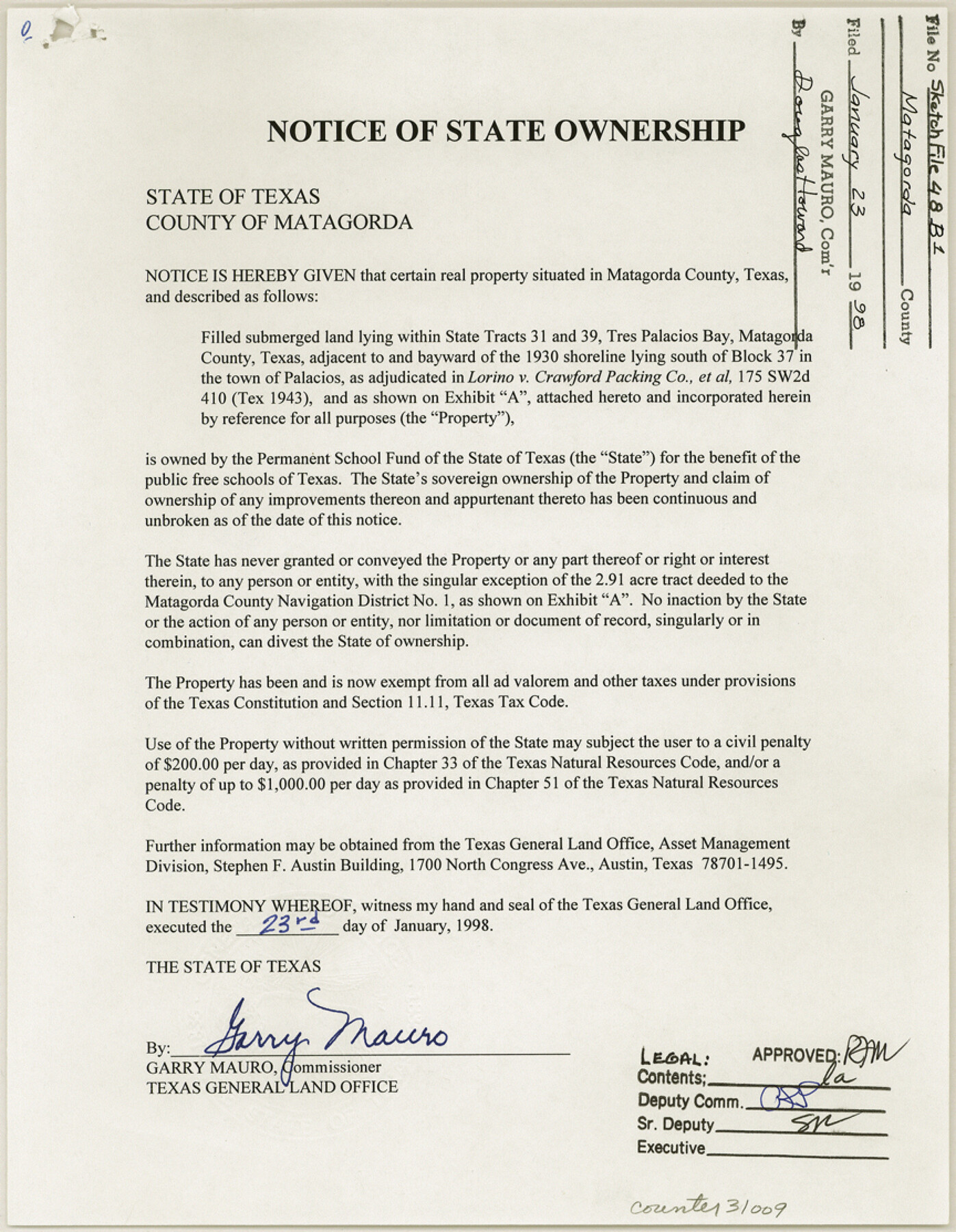
[Notice of state ownership of filled submerged land lying within State Tracts 31 and 39, Tres Palacios Bay adjacent to and bayward of the 1930 shoreline lying south of Block 37 in the town of Palacios]
-
Map/Doc
31009
-
Collection
General Map Collection
-
Object Dates
1/23/1998 (Creation Date)
2/5/1998 (File Date)
-
Counties
Matagorda
-
Subjects
Surveying Sketch File
-
Height x Width
11.1 x 8.6 inches
28.2 x 21.8 cm
-
Medium
multi-page, multi-format
-
Features
Tres Palacios Bay
Palacios
8th Street
Duson Street
Gulf of Mexico
Camp Hulen
South Bay Marina
Port of Palacios
Palacios Bay
South Bay Blvd.
City of Palacios Park Land
Part of: General Map Collection
Hardeman County Working Sketch 2

Print $20.00
- Digital $50.00
Hardeman County Working Sketch 2
1900
Size 19.1 x 19.4 inches
Map/Doc 63383
Goliad County Working Sketch 19

Print $20.00
- Digital $50.00
Goliad County Working Sketch 19
1954
Size 31.5 x 31.8 inches
Map/Doc 63209
Dallas County Rolled Sketch 4

Print $20.00
- Digital $50.00
Dallas County Rolled Sketch 4
1954
Size 13.1 x 24.2 inches
Map/Doc 5687
Red River County Working Sketch 70

Print $20.00
- Digital $50.00
Red River County Working Sketch 70
1977
Size 22.6 x 24.0 inches
Map/Doc 72053
McLennan County Sketch File 31

Print $22.00
- Digital $50.00
McLennan County Sketch File 31
Size 14.2 x 17.2 inches
Map/Doc 31306
Jeff Davis County Working Sketch 27

Print $20.00
- Digital $50.00
Jeff Davis County Working Sketch 27
1960
Size 18.1 x 24.3 inches
Map/Doc 66522
Shelby County Shelby District

Print $20.00
- Digital $50.00
Shelby County Shelby District
1880
Size 20.5 x 25.3 inches
Map/Doc 4030
Bowie County Working Sketch 1

Print $20.00
- Digital $50.00
Bowie County Working Sketch 1
Size 16.7 x 12.1 inches
Map/Doc 67405
Nueces County Rolled Sketch 128

Print $20.00
- Digital $50.00
Nueces County Rolled Sketch 128
1998
Size 18.3 x 24.5 inches
Map/Doc 7163

Cottle County Sketch File 11

Print $40.00
- Digital $50.00
Cottle County Sketch File 11
Size 12.9 x 13.3 inches
Map/Doc 19489
Paul McCombs Field Book on 80 Mile Reservation west of the Pecos

Print $148.00
- Digital $50.00
Paul McCombs Field Book on 80 Mile Reservation west of the Pecos
1883
Size 7.8 x 6.0 inches
Map/Doc 2238
You may also like
Concho County Rolled Sketch 27

Print $20.00
- Digital $50.00
Concho County Rolled Sketch 27
2002
Size 30.5 x 40.5 inches
Map/Doc 78514
Presidio County Rolled Sketch 36

Print $20.00
- Digital $50.00
Presidio County Rolled Sketch 36
Size 20.7 x 21.8 inches
Map/Doc 7334
San Jacinto County Rolled Sketch 14

Print $20.00
- Digital $50.00
San Jacinto County Rolled Sketch 14
1998
Size 28.1 x 40.0 inches
Map/Doc 7564

El Paso County Working Sketch 3

Print $20.00
- Digital $50.00
El Paso County Working Sketch 3
1916
Size 26.9 x 41.3 inches
Map/Doc 69025
Flight Mission No. CGI-3N, Frame 161, Cameron County

Print $20.00
- Digital $50.00
Flight Mission No. CGI-3N, Frame 161, Cameron County
1954
Size 18.7 x 22.4 inches
Map/Doc 84625
Flight Mission No. CRC-5R, Frame 23, Chambers County

Print $20.00
- Digital $50.00
Flight Mission No. CRC-5R, Frame 23, Chambers County
1956
Size 18.8 x 22.4 inches
Map/Doc 84945
Tarrant County State Real Property Sketch 4

Print $20.00
- Digital $50.00
Tarrant County State Real Property Sketch 4
2018
Size 47.8 x 35.9 inches
Map/Doc 95403
[Blocks 36 and 37, Townships 1S-5S]
![93213, [Blocks 36 and 37, Townships 1S-5S], Twichell Survey Records](https://historictexasmaps.com/wmedia_w700/maps/93213-1.tif.jpg)
Print $40.00
- Digital $50.00
[Blocks 36 and 37, Townships 1S-5S]
Size 28.9 x 83.7 inches
Map/Doc 93213
Jackson County Sketch File 3

Print $34.00
- Digital $50.00
Jackson County Sketch File 3
1875
Size 7.9 x 7.7 inches
Map/Doc 27621
Map of Texas in 1830 Showing Spanish Colonies

Print $20.00
- Digital $50.00
Map of Texas in 1830 Showing Spanish Colonies
Size 41.1 x 42.0 inches
Map/Doc 73588
