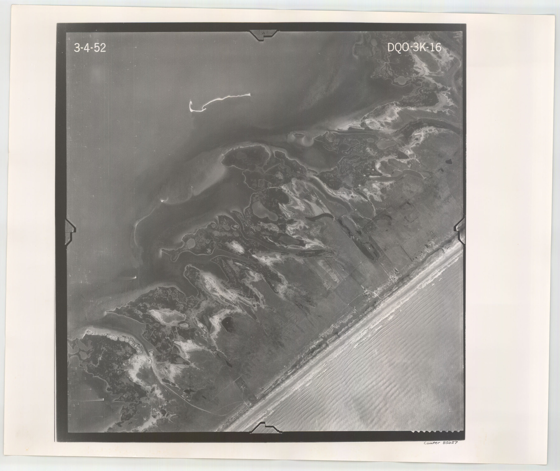
Flight Mission No. DQO-3K, Frame 16, Galveston County
DQO-3K-16
-
Map/Doc
85057
-
Collection
General Map Collection
-
Object Dates
1952/3/4 (Creation Date)
-
People and Organizations
U. S. Department of Agriculture (Publisher)
-
Counties
Galveston
-
Subjects
Aerial Photograph
-
Height x Width
18.9 x 22.5 inches
48.0 x 57.2 cm
-
Comments
Flown by Aero Exploration Company of Tulsa, Oklahoma.
Part of: General Map Collection
San Saba County

Print $20.00
- Digital $50.00
San Saba County
1987
Size 41.3 x 42.2 inches
Map/Doc 77417
Reagan County Sketch File 28

Print $20.00
- Digital $50.00
Reagan County Sketch File 28
1951
Size 29.6 x 21.7 inches
Map/Doc 12224
Map of Chicago, Rock Island & Texas Railway through Montague and Wise Counties, Texas

Print $40.00
- Digital $50.00
Map of Chicago, Rock Island & Texas Railway through Montague and Wise Counties, Texas
1893
Size 20.2 x 124.5 inches
Map/Doc 64468
Vicinity of San Luis Pass, Galveston Island, Texas

Print $40.00
- Digital $50.00
Vicinity of San Luis Pass, Galveston Island, Texas
1933
Size 36.9 x 57.2 inches
Map/Doc 69942
[Rosebud Station Map - Tracks and Structures - Lands, San Antonio and Aransas Pass Railway Co.]
![62566, [Rosebud Station Map - Tracks and Structures - Lands, San Antonio and Aransas Pass Railway Co.], General Map Collection](https://historictexasmaps.com/wmedia_w700/maps/62566.tif.jpg)
Print $4.00
- Digital $50.00
[Rosebud Station Map - Tracks and Structures - Lands, San Antonio and Aransas Pass Railway Co.]
1919
Size 11.7 x 18.6 inches
Map/Doc 62566
Map of the State of Coahuila and Texas

Map of the State of Coahuila and Texas
1834
Size 13.3 x 14.9 inches
Map/Doc 96969
Nolan County Boundary File 1

Print $60.00
- Digital $50.00
Nolan County Boundary File 1
Size 8.8 x 3.9 inches
Map/Doc 57617
Travis County Sketch File 57

Print $8.00
- Digital $50.00
Travis County Sketch File 57
1947
Size 11.4 x 8.8 inches
Map/Doc 38402
Map of Limestone County

Print $20.00
- Digital $50.00
Map of Limestone County
1877
Size 24.1 x 26.9 inches
Map/Doc 83012
Map of the World on a Globular Projection to illustrate Olney's school geography

Print $20.00
- Digital $50.00
Map of the World on a Globular Projection to illustrate Olney's school geography
1844
Size 12.1 x 19.0 inches
Map/Doc 93535
Edwards County Sketch File 2 and 3

Print $8.00
- Digital $50.00
Edwards County Sketch File 2 and 3
1874
Size 9.3 x 4.1 inches
Map/Doc 21676
Grimes County Working Sketch Graphic Index

Print $40.00
- Digital $50.00
Grimes County Working Sketch Graphic Index
1922
Size 54.9 x 29.4 inches
Map/Doc 76560
You may also like
Maverick County Sketch File 24

Print $36.00
- Digital $50.00
Maverick County Sketch File 24
1890
Size 9.1 x 8.7 inches
Map/Doc 31145

Morris County Rolled Sketch 2A

Print $20.00
- Digital $50.00
Morris County Rolled Sketch 2A
Size 24.0 x 18.8 inches
Map/Doc 10252
Texas Intracoastal Waterway, Aransas Bay to Aransas Pass

Print $20.00
- Digital $50.00
Texas Intracoastal Waterway, Aransas Bay to Aransas Pass
1962
Size 38.7 x 26.8 inches
Map/Doc 73439
Map Showing Block HG and Connecting Surveys

Print $2.00
- Digital $50.00
Map Showing Block HG and Connecting Surveys
1907
Size 9.2 x 13.7 inches
Map/Doc 90681
[Leagues 464-467]
![91555, [Leagues 464-467], Twichell Survey Records](https://historictexasmaps.com/wmedia_w700/maps/91555-1.tif.jpg)
Print $20.00
- Digital $50.00
[Leagues 464-467]
Size 19.4 x 15.1 inches
Map/Doc 91555
Cooke County Boundary File 19

Print $30.00
- Digital $50.00
Cooke County Boundary File 19
Size 8.7 x 4.0 inches
Map/Doc 51858
Hutchinson County Boundary File 1

Print $82.00
- Digital $50.00
Hutchinson County Boundary File 1
Size 8.7 x 38.3 inches
Map/Doc 55292
Flight Mission No. BQR-13K, Frame 120, Brazoria County

Print $20.00
- Digital $50.00
Flight Mission No. BQR-13K, Frame 120, Brazoria County
1952
Size 18.8 x 22.5 inches
Map/Doc 84081
Archer County Working Sketch 13

Print $20.00
- Digital $50.00
Archer County Working Sketch 13
1939
Size 12.0 x 18.5 inches
Map/Doc 67154
Brown County Working Sketch 18

Print $20.00
- Digital $50.00
Brown County Working Sketch 18
1994
Size 43.0 x 29.3 inches
Map/Doc 67783
Bandera County Working Sketch 7

Print $20.00
- Digital $50.00
Bandera County Working Sketch 7
1920
Size 18.1 x 22.5 inches
Map/Doc 67600