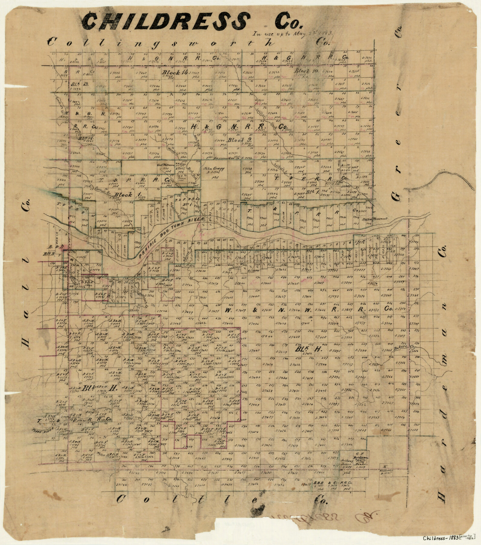
Childress County
-
Map/Doc
3394
-
Collection
General Map Collection
-
Object Dates
1883 (Creation Date)
-
Counties
Childress
-
Subjects
County
-
Height x Width
20.8 x 19.0 inches
52.8 x 48.3 cm
-
Comments
Note on map: "In use up to May 2, 1883".
-
Features
Conklin's Creek
Whites Creek
Pease River
Bakers Creek
Hutchins' Creek
Ross Creek
Thornton's Creek
Prairie Dog Town River
Robinson Creek
Cousin's Creek
Initial Monument
Gardners Creek
Myrick's Creek
Salt Fork of Myrick's Creek
Fresh Fork [of Myrick's Creek]
Clear Creek
Spiller's Creek
Part of: General Map Collection
Galveston County NRC Article 33.136 Location Key Sheet

Print $20.00
- Digital $50.00
Galveston County NRC Article 33.136 Location Key Sheet
1974
Size 27.0 x 23.0 inches
Map/Doc 77022
Archer County Sketch File 30

Print $40.00
- Digital $50.00
Archer County Sketch File 30
1896
Size 20.6 x 18.5 inches
Map/Doc 10838
University Land Field Notes for Blocks 12, 13, and 14 in Andrews County, and Block 11 in Andrews and Winkler Counties

University Land Field Notes for Blocks 12, 13, and 14 in Andrews County, and Block 11 in Andrews and Winkler Counties
Map/Doc 81711
Runnels County Rolled Sketch 18

Print $20.00
- Digital $50.00
Runnels County Rolled Sketch 18
Size 23.1 x 25.3 inches
Map/Doc 7513
Coke County Working Sketch 2

Print $20.00
- Digital $50.00
Coke County Working Sketch 2
Size 22.8 x 22.3 inches
Map/Doc 68039
Rusk County Rolled Sketch 7

Print $20.00
- Digital $50.00
Rusk County Rolled Sketch 7
Size 43.0 x 37.3 inches
Map/Doc 9876

Chambers County Rolled Sketch 33

Print $71.00
- Digital $50.00
Chambers County Rolled Sketch 33
1950
Size 10.7 x 15.6 inches
Map/Doc 44106
Shackelford County Boundary File 7

Print $74.00
- Digital $50.00
Shackelford County Boundary File 7
Size 11.6 x 8.9 inches
Map/Doc 58671

Shelby County Working Sketch 28

Print $20.00
- Digital $50.00
Shelby County Working Sketch 28
2000
Size 28.8 x 29.8 inches
Map/Doc 63882
Flight Mission No. CRC-3R, Frame 43, Chambers County

Print $20.00
- Digital $50.00
Flight Mission No. CRC-3R, Frame 43, Chambers County
1956
Size 18.5 x 22.3 inches
Map/Doc 84816
You may also like
[Surveys in the Bexar District along the Frio River]
![315, [Surveys in the Bexar District along the Frio River], General Map Collection](https://historictexasmaps.com/wmedia_w700/maps/315.tif.jpg)
Print $2.00
- Digital $50.00
[Surveys in the Bexar District along the Frio River]
1847
Size 15.8 x 9.2 inches
Map/Doc 315
Map of Southeastern Part of Young Territory

Print $40.00
- Digital $50.00
Map of Southeastern Part of Young Territory
1874
Size 54.7 x 30.1 inches
Map/Doc 1989
Medina County Working Sketch 3

Print $40.00
- Digital $50.00
Medina County Working Sketch 3
1945
Size 52.6 x 37.1 inches
Map/Doc 70918
[Dennis Corwin's Map of Survey for R. N. Graham]
![83427, [Dennis Corwin's Map of Survey for R. N. Graham], Maddox Collection](https://historictexasmaps.com/wmedia_w700/maps/83427.tif.jpg)
Print $2.00
- Digital $50.00
[Dennis Corwin's Map of Survey for R. N. Graham]
Size 11.1 x 8.5 inches
Map/Doc 83427
San Augustine County Texas

Print $20.00
- Digital $50.00
San Augustine County Texas
1879
Size 23.8 x 16.9 inches
Map/Doc 4623
Burnham Townsite at Justiceburg

Print $20.00
- Digital $50.00
Burnham Townsite at Justiceburg
Size 36.6 x 29.0 inches
Map/Doc 92694
Frio County Working Sketch Graphic Index

Print $20.00
- Digital $50.00
Frio County Working Sketch Graphic Index
1944
Size 43.0 x 41.4 inches
Map/Doc 76549
Map of Texas and the countries adjacent compiled in the Bureau of the Corps of Topographical Engineers from the best authorities for the State Department

Print $20.00
- Digital $50.00
Map of Texas and the countries adjacent compiled in the Bureau of the Corps of Topographical Engineers from the best authorities for the State Department
1844
Size 25.9 x 18.2 inches
Map/Doc 72714

Jim Hogg County

Print $20.00
- Digital $50.00
Jim Hogg County
1962
Size 40.3 x 28.5 inches
Map/Doc 77330
Flight Mission No. DQN-1K, Frame 49, Calhoun County

Print $20.00
- Digital $50.00
Flight Mission No. DQN-1K, Frame 49, Calhoun County
1953
Size 18.6 x 22.4 inches
Map/Doc 84149
Cottle County Sketch File 5

Print $6.00
- Digital $50.00
Cottle County Sketch File 5
1883
Size 17.0 x 9.6 inches
Map/Doc 19474