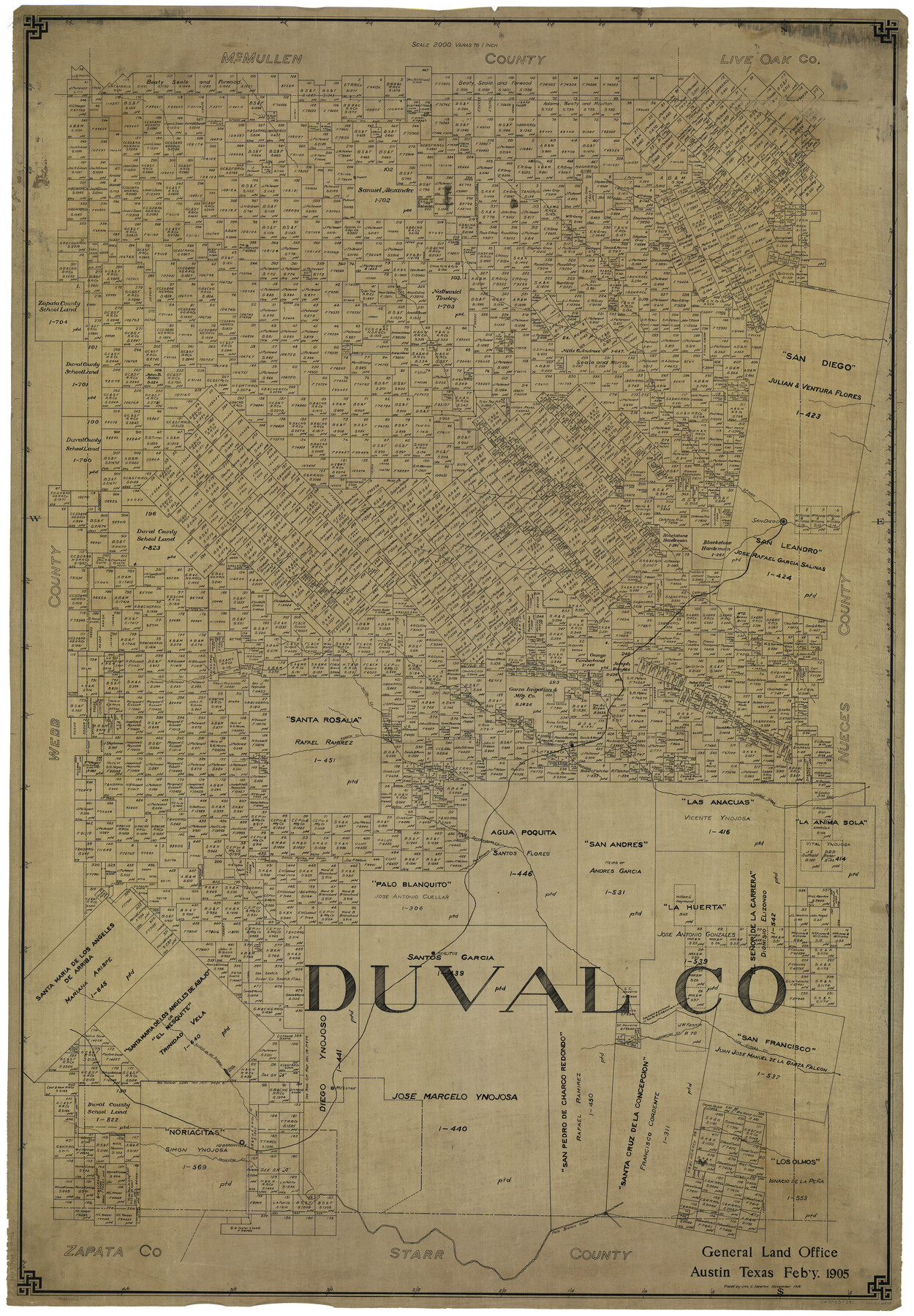
Duval Co.
-
Map/Doc
66808
-
Collection
General Map Collection
-
Object Dates
2/1905 (Creation Date)
11/1918 (Tracing Date)
-
People and Organizations
John C. Newton (Tracer)
-
Counties
Duval
-
Subjects
County
-
Height x Width
60.7 x 42.5 inches
154.2 x 108.0 cm
Part of: General Map Collection
Leon County Working Sketch 49

Print $20.00
- Digital $50.00
Leon County Working Sketch 49
1981
Size 23.9 x 24.7 inches
Map/Doc 70448
Limestone County Working Sketch 14

Print $20.00
- Digital $50.00
Limestone County Working Sketch 14
1922
Size 36.2 x 34.1 inches
Map/Doc 70564
Concho County Working Sketch 17

Print $20.00
- Digital $50.00
Concho County Working Sketch 17
1956
Size 20.9 x 23.4 inches
Map/Doc 68199
Map of the Rio Grande & Eagle Pass Ry. from Sections 21-25 9/10 Inclusive, Webb County

Print $40.00
- Digital $50.00
Map of the Rio Grande & Eagle Pass Ry. from Sections 21-25 9/10 Inclusive, Webb County
1909
Size 25.8 x 55.4 inches
Map/Doc 64658
Gonzales County

Print $40.00
- Digital $50.00
Gonzales County
1986
Size 39.9 x 52.0 inches
Map/Doc 77292
Cass County Rolled Sketch 1

Print $20.00
- Digital $50.00
Cass County Rolled Sketch 1
1945
Size 22.1 x 23.7 inches
Map/Doc 5408
El Paso County Sketch File 13

Print $8.00
- Digital $50.00
El Paso County Sketch File 13
1905
Size 7.4 x 6.8 inches
Map/Doc 22005
Cass County Sketch File 18

Print $4.00
- Digital $50.00
Cass County Sketch File 18
Size 7.4 x 10.3 inches
Map/Doc 17420
Callahan County Working Sketch 4

Print $20.00
- Digital $50.00
Callahan County Working Sketch 4
1953
Size 17.1 x 27.0 inches
Map/Doc 67886
Maps of Gulf Intracoastal Waterway, Texas - Sabine River to the Rio Grande and connecting waterways including ship channels

Print $20.00
- Digital $50.00
Maps of Gulf Intracoastal Waterway, Texas - Sabine River to the Rio Grande and connecting waterways including ship channels
1966
Size 14.5 x 22.2 inches
Map/Doc 61926
Andrews County Working Sketch 5

Print $20.00
- Digital $50.00
Andrews County Working Sketch 5
1954
Size 21.7 x 43.0 inches
Map/Doc 67051
Hutchinson County Rolled Sketch 16

Print $20.00
- Digital $50.00
Hutchinson County Rolled Sketch 16
1912
Size 27.5 x 30.2 inches
Map/Doc 6284
You may also like
Carson County Boundary File 6

Print $48.00
- Digital $50.00
Carson County Boundary File 6
Size 12.8 x 8.3 inches
Map/Doc 51151
Hudspeth County Working Sketch 11

Print $20.00
- Digital $50.00
Hudspeth County Working Sketch 11
1946
Size 32.1 x 36.2 inches
Map/Doc 66292
Dallas County Working Sketch 14

Print $20.00
- Digital $50.00
Dallas County Working Sketch 14
1987
Size 31.2 x 21.7 inches
Map/Doc 68580
Cameron County Rolled Sketch 25

Print $20.00
- Digital $50.00
Cameron County Rolled Sketch 25
1977
Size 24.8 x 36.6 inches
Map/Doc 5798
Terrell County Working Sketch 29

Print $20.00
- Digital $50.00
Terrell County Working Sketch 29
1944
Size 28.6 x 35.5 inches
Map/Doc 62121
[Movements & Objectives of the 143rd & 144th Infantry on October 12-13, 1918, Appendix E, No.1]
![94126, [Movements & Objectives of the 143rd & 144th Infantry on October 12-13, 1918, Appendix E, No.1], Non-GLO Digital Images](https://historictexasmaps.com/wmedia_w700/maps/94126-1.tif.jpg)
Print $20.00
[Movements & Objectives of the 143rd & 144th Infantry on October 12-13, 1918, Appendix E, No.1]
1918
Size 22.5 x 20.0 inches
Map/Doc 94126
Colonial Texas. 1822 to 1834.

Print $20.00
- Digital $50.00
Colonial Texas. 1822 to 1834.
1897
Size 12.8 x 16.3 inches
Map/Doc 93410
Sulphur River, Ringo Crossing Sheet

Print $20.00
- Digital $50.00
Sulphur River, Ringo Crossing Sheet
1933
Size 30.5 x 35.9 inches
Map/Doc 65162
Map of Travis County

Print $40.00
- Digital $50.00
Map of Travis County
1894
Size 49.8 x 58.8 inches
Map/Doc 16904
Garza County Rolled Sketch P

Print $20.00
- Digital $50.00
Garza County Rolled Sketch P
1914
Size 21.3 x 23.3 inches
Map/Doc 6005

Cooke County Sketch File 9a

Print $4.00
- Digital $50.00
Cooke County Sketch File 9a
Size 8.2 x 9.4 inches
Map/Doc 19240