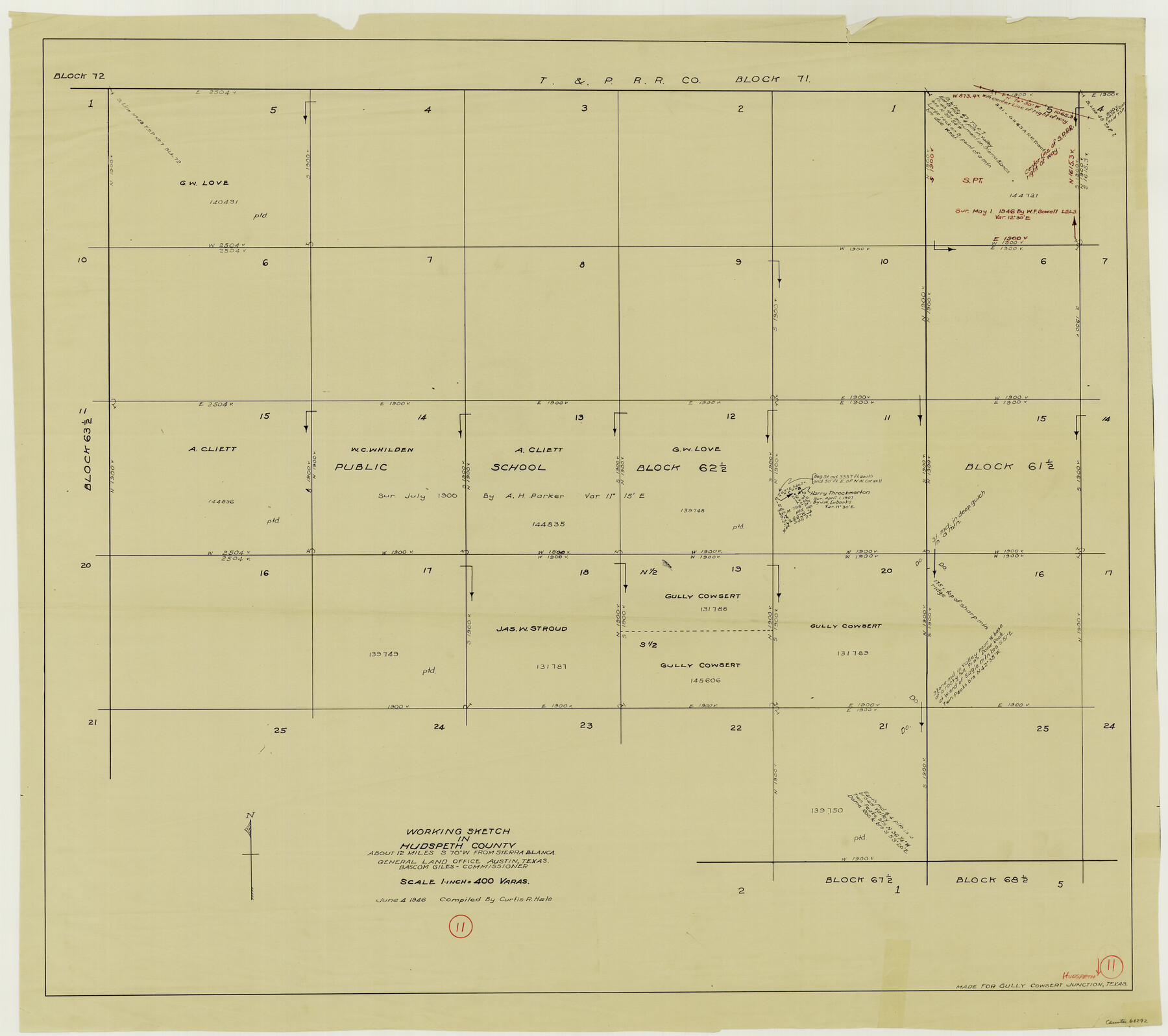
Hudspeth County Working Sketch 11
-
Map/Doc
66292
-
Collection
General Map Collection
-
Object Dates
6/4/1946 (Creation Date)
-
People and Organizations
Curtis R. Hale (Draftsman)
-
Counties
Hudspeth
-
Subjects
Surveying Working Sketch
-
Height x Width
32.1 x 36.2 inches
81.5 x 92.0 cm
-
Scale
1" = 400 varas
Part of: General Map Collection
Plan of the City of Galveston, Texas

Print $20.00
- Digital $50.00
Plan of the City of Galveston, Texas
1845
Size 18.2 x 27.4 inches
Map/Doc 62969
Pecos County Working Sketch 122

Print $40.00
- Digital $50.00
Pecos County Working Sketch 122
1973
Size 51.9 x 36.7 inches
Map/Doc 71595
Baylor County Working Sketch Graphic Index

Print $20.00
- Digital $50.00
Baylor County Working Sketch Graphic Index
1961
Size 41.1 x 33.6 inches
Map/Doc 76463
Map of part of the State of Texas

Print $3.00
- Digital $50.00
Map of part of the State of Texas
1857
Size 8.0 x 9.6 inches
Map/Doc 95363
Fort Bend County State Real Property Sketch 9

Print $40.00
- Digital $50.00
Fort Bend County State Real Property Sketch 9
1986
Size 34.7 x 43.2 inches
Map/Doc 61683
University Land, Block 48, Culberson County, Texas

Print $20.00
- Digital $50.00
University Land, Block 48, Culberson County, Texas
1938
Size 28.1 x 21.7 inches
Map/Doc 2411
Andrews County Rolled Sketch 30

Print $20.00
- Digital $50.00
Andrews County Rolled Sketch 30
Size 20.6 x 18.1 inches
Map/Doc 77174
Pecos County Rolled Sketch 97

Print $20.00
- Digital $50.00
Pecos County Rolled Sketch 97
Size 24.7 x 36.8 inches
Map/Doc 7248
Sutton County Working Sketch 25

Print $40.00
- Digital $50.00
Sutton County Working Sketch 25
Size 69.4 x 37.1 inches
Map/Doc 62368
South Part of El Paso Co.

Print $20.00
- Digital $50.00
South Part of El Paso Co.
1977
Size 30.5 x 40.8 inches
Map/Doc 77274
Colorado County Sketch File 32

Print $4.00
- Digital $50.00
Colorado County Sketch File 32
1847
Size 13.0 x 8.4 inches
Map/Doc 18986
Acreage in Texas by Counties

Acreage in Texas by Counties
1983
Size 10.3 x 11.8 inches
Map/Doc 97033
You may also like
Cass County Working Sketch 5

Print $20.00
- Digital $50.00
Cass County Working Sketch 5
1936
Size 45.6 x 43.1 inches
Map/Doc 67908
Certified description of Houston & Gt. Northern Railrd. from Houston to Trinity River

Print $12.00
- Digital $50.00
Certified description of Houston & Gt. Northern Railrd. from Houston to Trinity River
1871
Size 12.9 x 7.9 inches
Map/Doc 64302
Tom Green County Sketch File 82

Print $20.00
- Digital $50.00
Tom Green County Sketch File 82
1888
Size 18.5 x 20.9 inches
Map/Doc 12454
Graham's Addition Being a Subdivision of a Portion of Lot No. 1 of Spear League

Print $20.00
- Digital $50.00
Graham's Addition Being a Subdivision of a Portion of Lot No. 1 of Spear League
1914
Size 13.6 x 33.0 inches
Map/Doc 542
Chart of the West Indies and Spanish Dominions in North America

Print $40.00
- Digital $50.00
Chart of the West Indies and Spanish Dominions in North America
Size 49.1 x 75.6 inches
Map/Doc 97153
Flight Mission No. DAG-17K, Frame 143, Matagorda County

Print $20.00
- Digital $50.00
Flight Mission No. DAG-17K, Frame 143, Matagorda County
1952
Size 16.4 x 16.4 inches
Map/Doc 86360
Shelby County Working Sketch 21

Print $20.00
- Digital $50.00
Shelby County Working Sketch 21
1981
Size 31.0 x 23.3 inches
Map/Doc 63874
General Highway Map. Detail of Cities and Towns in Val Verde County, Texas [Del Rio and vicinity]
![79695, General Highway Map. Detail of Cities and Towns in Val Verde County, Texas [Del Rio and vicinity], Texas State Library and Archives](https://historictexasmaps.com/wmedia_w700/maps/79695.tif.jpg)
Print $20.00
General Highway Map. Detail of Cities and Towns in Val Verde County, Texas [Del Rio and vicinity]
1961
Size 18.0 x 24.8 inches
Map/Doc 79695
Travis County Rolled Sketch 4

Print $20.00
- Digital $50.00
Travis County Rolled Sketch 4
1915
Size 19.7 x 35.6 inches
Map/Doc 8010
Chambers County Aerial Photograph Index Sheet 2

Print $20.00
- Digital $50.00
Chambers County Aerial Photograph Index Sheet 2
1956
Size 19.4 x 15.7 inches
Map/Doc 83683
Flight Mission No. CGI-3N, Frame 122, Cameron County

Print $20.00
- Digital $50.00
Flight Mission No. CGI-3N, Frame 122, Cameron County
1954
Size 18.6 x 22.2 inches
Map/Doc 84595
Preliminary Chart of the Northwestern Part of the Gulf of Mexico

Print $20.00
Preliminary Chart of the Northwestern Part of the Gulf of Mexico
1855
Size 32.3 x 41.6 inches
Map/Doc 79334