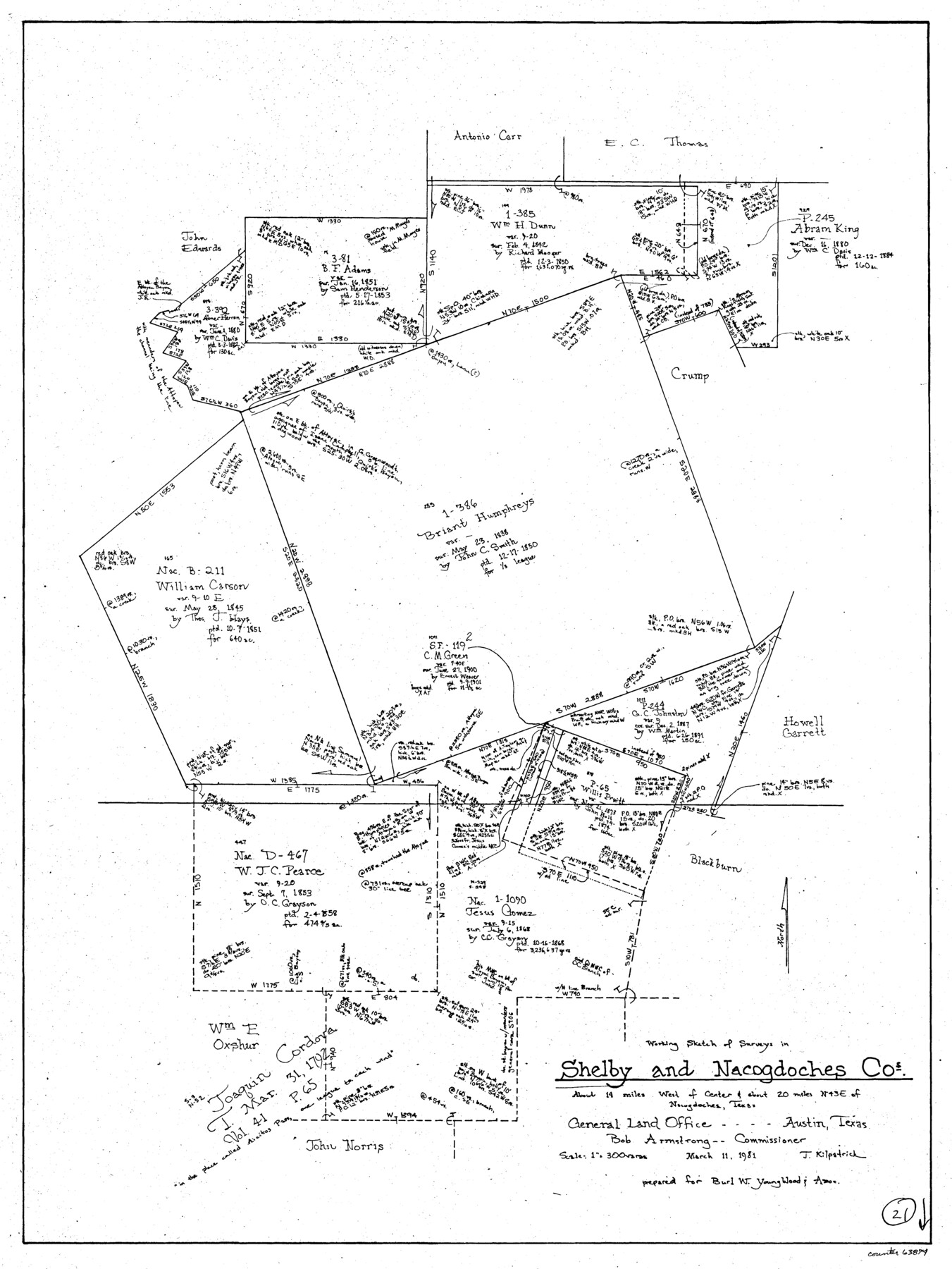
Shelby County Working Sketch 21
-
Map/Doc
63874
-
Collection
General Map Collection
-
Object Dates
3/11/1981 (Creation Date)
-
People and Organizations
Joan Kilpatrick (Draftsman)
-
Counties
Shelby Nacogdoches
-
Subjects
Surveying Working Sketch
-
Height x Width
31.0 x 23.3 inches
78.7 x 59.2 cm
-
Scale
1" = 300 varas
Part of: General Map Collection
Val Verde County Rolled Sketch 49

Print $20.00
- Digital $50.00
Val Verde County Rolled Sketch 49
Size 26.9 x 34.3 inches
Map/Doc 8120
Calhoun County Rolled Sketch 11

Print $20.00
- Digital $50.00
Calhoun County Rolled Sketch 11
1942
Size 10.6 x 40.7 inches
Map/Doc 5367
[San Patricio No. 2]
![69746, [San Patricio No. 2], General Map Collection](https://historictexasmaps.com/wmedia_w700/maps/69746.tif.jpg)
Print $2.00
- Digital $50.00
[San Patricio No. 2]
1847
Size 8.3 x 11.2 inches
Map/Doc 69746
Kerr County Sketch File 24

Print $20.00
- Digital $50.00
Kerr County Sketch File 24
1967
Size 15.7 x 21.6 inches
Map/Doc 11923
Flight Mission No. CGI-4N, Frame 190, Cameron County

Print $20.00
- Digital $50.00
Flight Mission No. CGI-4N, Frame 190, Cameron County
1955
Size 18.5 x 22.2 inches
Map/Doc 84693
Cottle County Working Sketch 13

Print $20.00
- Digital $50.00
Cottle County Working Sketch 13
1960
Size 19.6 x 25.0 inches
Map/Doc 68323
Harris County NRC Article 33.136 Sketch 19

Print $50.00
- Digital $50.00
Harris County NRC Article 33.136 Sketch 19
2014
Size 24.6 x 36.6 inches
Map/Doc 95334
[From the lower corner of the Juan Zambrano survey to the Medina River]
![97, [From the lower corner of the Juan Zambrano survey to the Medina River], General Map Collection](https://historictexasmaps.com/wmedia_w700/maps/97.tif.jpg)
Print $20.00
- Digital $50.00
[From the lower corner of the Juan Zambrano survey to the Medina River]
1844
Size 19.0 x 8.0 inches
Map/Doc 97
Orange County Working Sketch 54b

Print $40.00
- Digital $50.00
Orange County Working Sketch 54b
2008
Size 38.0 x 50.3 inches
Map/Doc 88743
Lubbock County Boundary File 11

Print $68.00
- Digital $50.00
Lubbock County Boundary File 11
Size 14.7 x 9.2 inches
Map/Doc 56583
Upton County Sketch File 6

Print $10.00
- Digital $50.00
Upton County Sketch File 6
1909
Size 11.3 x 8.6 inches
Map/Doc 38815
Map of Fort Stockton

Print $20.00
- Digital $50.00
Map of Fort Stockton
Size 22.4 x 18.3 inches
Map/Doc 76870
You may also like
Brewster County Rolled Sketch 139

Print $20.00
- Digital $50.00
Brewster County Rolled Sketch 139
1982
Size 24.4 x 38.0 inches
Map/Doc 5307
Van Zandt County Sketch File 5

Print $22.00
- Digital $50.00
Van Zandt County Sketch File 5
Size 20.5 x 6.3 inches
Map/Doc 39371
Orange County Sketch File 32

Print $6.00
- Digital $50.00
Orange County Sketch File 32
1926
Size 14.3 x 8.7 inches
Map/Doc 33360
Culberson County Working Sketch 86

Print $40.00
- Digital $50.00
Culberson County Working Sketch 86
1981
Size 37.3 x 53.3 inches
Map/Doc 68540
Roberts County Working Sketch 12

Print $20.00
- Digital $50.00
Roberts County Working Sketch 12
Size 25.5 x 22.5 inches
Map/Doc 63538
Woodbury Empresario Colony. November 14, 1826

Print $20.00
Woodbury Empresario Colony. November 14, 1826
2020
Size 14.7 x 21.8 inches
Map/Doc 96011
Leon County Working Sketch 14

Print $40.00
- Digital $50.00
Leon County Working Sketch 14
1956
Size 48.8 x 34.5 inches
Map/Doc 70413
Pecos County Rolled Sketch 39A

Print $20.00
- Digital $50.00
Pecos County Rolled Sketch 39A
1908
Size 23.8 x 35.9 inches
Map/Doc 7218
Hays County Rolled Sketch 29

Print $20.00
- Digital $50.00
Hays County Rolled Sketch 29
1954
Size 26.1 x 28.0 inches
Map/Doc 6184
Kerr County Sketch File 8

Print $4.00
- Digital $50.00
Kerr County Sketch File 8
1882
Size 12.6 x 8.1 inches
Map/Doc 28871
Frio County Rolled Sketch 20

Print $40.00
- Digital $50.00
Frio County Rolled Sketch 20
1956
Size 31.0 x 59.4 inches
Map/Doc 8910
Map of Asia designed to accompany Smith's Geography for Schools

Print $20.00
- Digital $50.00
Map of Asia designed to accompany Smith's Geography for Schools
1850
Size 9.6 x 12.0 inches
Map/Doc 93896