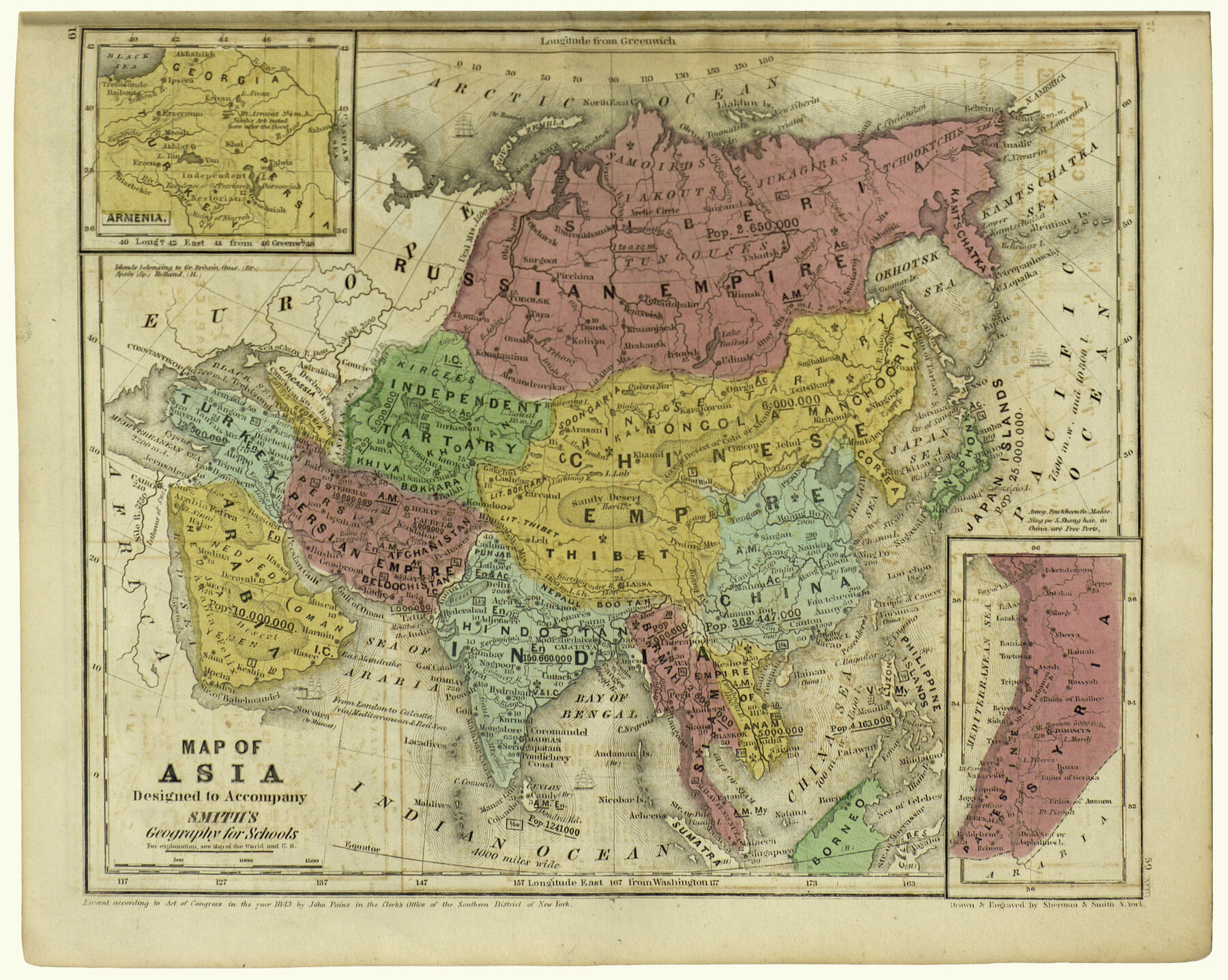
Map of Asia designed to accompany Smith's Geography for Schools
[Inset 1:] Armenia / [Inset 2: Syria and Palestine]
-
Map/Doc
93896
-
Collection
Holcomb Digital Map Collection
-
Object Dates
1850 (Creation Date)
-
People and Organizations
Sherman and Smith (Printer)
Sherman and Smith (Draftsman)
-
Subjects
Asia Atlas
-
Height x Width
9.6 x 12.0 inches
24.4 x 30.5 cm
-
Comments
Courtesy of Frank and Carol Holcomb.
Part of: Holcomb Digital Map Collection
Richardson's New Map of the State of Texas Including Part of Mexico Compiled From Government Surveys and Other Authentic Documents

Print $20.00
- Digital $50.00
Richardson's New Map of the State of Texas Including Part of Mexico Compiled From Government Surveys and Other Authentic Documents
1860
Size 28.5 x 36.3 inches
Map/Doc 96788
Bird's Eye View of the City of Houston, Texas

Print $20.00
- Digital $50.00
Bird's Eye View of the City of Houston, Texas
1873
Size 25.2 x 31.5 inches
Map/Doc 93908
Nuevo Mapa Geographico de la America Septentrional, Perteneciente al Virreynato de Mexico

Print $20.00
- Digital $50.00
Nuevo Mapa Geographico de la America Septentrional, Perteneciente al Virreynato de Mexico
1768
Size 23.1 x 30.3 inches
Map/Doc 93835
Traveller's Map of the State of Texas

Print $20.00
- Digital $50.00
Traveller's Map of the State of Texas
1867
Size 43.4 x 41.6 inches
Map/Doc 93906
Map of Texas and the Countries Adjacent compiled in the Bureau of the Corps of Topographical Engineers from the Best Authorities

Print $2.00
- Digital $50.00
Map of Texas and the Countries Adjacent compiled in the Bureau of the Corps of Topographical Engineers from the Best Authorities
1844
Size 8.1 x 5.0 inches
Map/Doc 93868
Map of Mexico, including Yucatan & Upper California, exhibiting the chief cities and towns, the principal travelling routes &c.

Print $20.00
- Digital $50.00
Map of Mexico, including Yucatan & Upper California, exhibiting the chief cities and towns, the principal travelling routes &c.
1846
Size 18.3 x 26.1 inches
Map/Doc 93871
Map of Texas compiled from surveys included in the General Land Office

Print $20.00
- Digital $50.00
Map of Texas compiled from surveys included in the General Land Office
1851
Size 31.4 x 25.3 inches
Map/Doc 94417
A Map of the Internal Provinces of New Spain

Print $20.00
- Digital $50.00
A Map of the Internal Provinces of New Spain
1807
Size 20.9 x 20.0 inches
Map/Doc 97239
America siue India Nova ad magnae Gerardi Mercatoris aui Vniversalis imitationem in compendium redacta

Print $20.00
- Digital $50.00
America siue India Nova ad magnae Gerardi Mercatoris aui Vniversalis imitationem in compendium redacta
1595
Size 18.3 x 21.6 inches
Map/Doc 93807
America Settentrionale Colle Nuoue Scoperte fin all' Anno 1688

Print $20.00
- Digital $50.00
America Settentrionale Colle Nuoue Scoperte fin all' Anno 1688
1688
Size 25.4 x 37.6 inches
Map/Doc 96506
Map of Texas shewing the grants in possession of the Colorado & Red River Land Compy

Print $20.00
- Digital $50.00
Map of Texas shewing the grants in possession of the Colorado & Red River Land Compy
1835
Size 20.3 x 26.9 inches
Map/Doc 93850
Karte von Texas entworfen nach den Vermessungen welche in den Acten der General-Land-Office der Republick

Print $20.00
- Digital $50.00
Karte von Texas entworfen nach den Vermessungen welche in den Acten der General-Land-Office der Republick
1846
Size 16.9 x 17.6 inches
Map/Doc 94118
You may also like
![94196, New Mexico [Recto], General Map Collection](https://historictexasmaps.com/wmedia_w700/maps/94196.tif.jpg)
[Three Positions Concluded, Exhibit F]
![91371, [Three Positions Concluded, Exhibit F], Twichell Survey Records](https://historictexasmaps.com/wmedia_w700/maps/91371-1.tif.jpg)
Print $20.00
- Digital $50.00
[Three Positions Concluded, Exhibit F]
Size 26.0 x 16.4 inches
Map/Doc 91371
Copy of Surveyor's Field Book, Morris Browning - In Blocks 7, 5 & 4, I&GNRRCo., Hutchinson and Carson Counties, Texas

Print $2.00
- Digital $50.00
Copy of Surveyor's Field Book, Morris Browning - In Blocks 7, 5 & 4, I&GNRRCo., Hutchinson and Carson Counties, Texas
1888
Size 7.0 x 8.9 inches
Map/Doc 62266
Galveston Bay Entrance

Print $20.00
- Digital $50.00
Galveston Bay Entrance
1953
Size 26.1 x 42.2 inches
Map/Doc 69860
Nacogdoches County Working Sketch 8

Print $20.00
- Digital $50.00
Nacogdoches County Working Sketch 8
1964
Size 28.0 x 22.7 inches
Map/Doc 71224
Houston County Sketch File 7

Print $6.00
- Digital $50.00
Houston County Sketch File 7
1861
Size 12.0 x 11.1 inches
Map/Doc 26764
Flight Mission No. CRC-4R, Frame 67, Chambers County

Print $20.00
- Digital $50.00
Flight Mission No. CRC-4R, Frame 67, Chambers County
1956
Size 18.8 x 22.5 inches
Map/Doc 84871
Upshur County Working Sketch 6

Print $20.00
- Digital $50.00
Upshur County Working Sketch 6
1943
Size 28.6 x 34.3 inches
Map/Doc 69562
Kimble County Boundary File 3

Print $44.00
- Digital $50.00
Kimble County Boundary File 3
Size 9.8 x 32.4 inches
Map/Doc 64846
Flight Mission No. CRC-2R, Frame 60, Chambers County

Print $20.00
- Digital $50.00
Flight Mission No. CRC-2R, Frame 60, Chambers County
1956
Size 18.4 x 22.3 inches
Map/Doc 84731
Cooke County Sketch File 33

Print $44.00
- Digital $50.00
Cooke County Sketch File 33
1873
Size 13.4 x 26.5 inches
Map/Doc 11174
[Cotton Belt, St. Louis Southwestern Railway of Texas, Alignment through Smith County]
![64374, [Cotton Belt, St. Louis Southwestern Railway of Texas, Alignment through Smith County], General Map Collection](https://historictexasmaps.com/wmedia_w700/maps/64374.tif.jpg)
Print $20.00
- Digital $50.00
[Cotton Belt, St. Louis Southwestern Railway of Texas, Alignment through Smith County]
1903
Size 21.5 x 29.3 inches
Map/Doc 64374