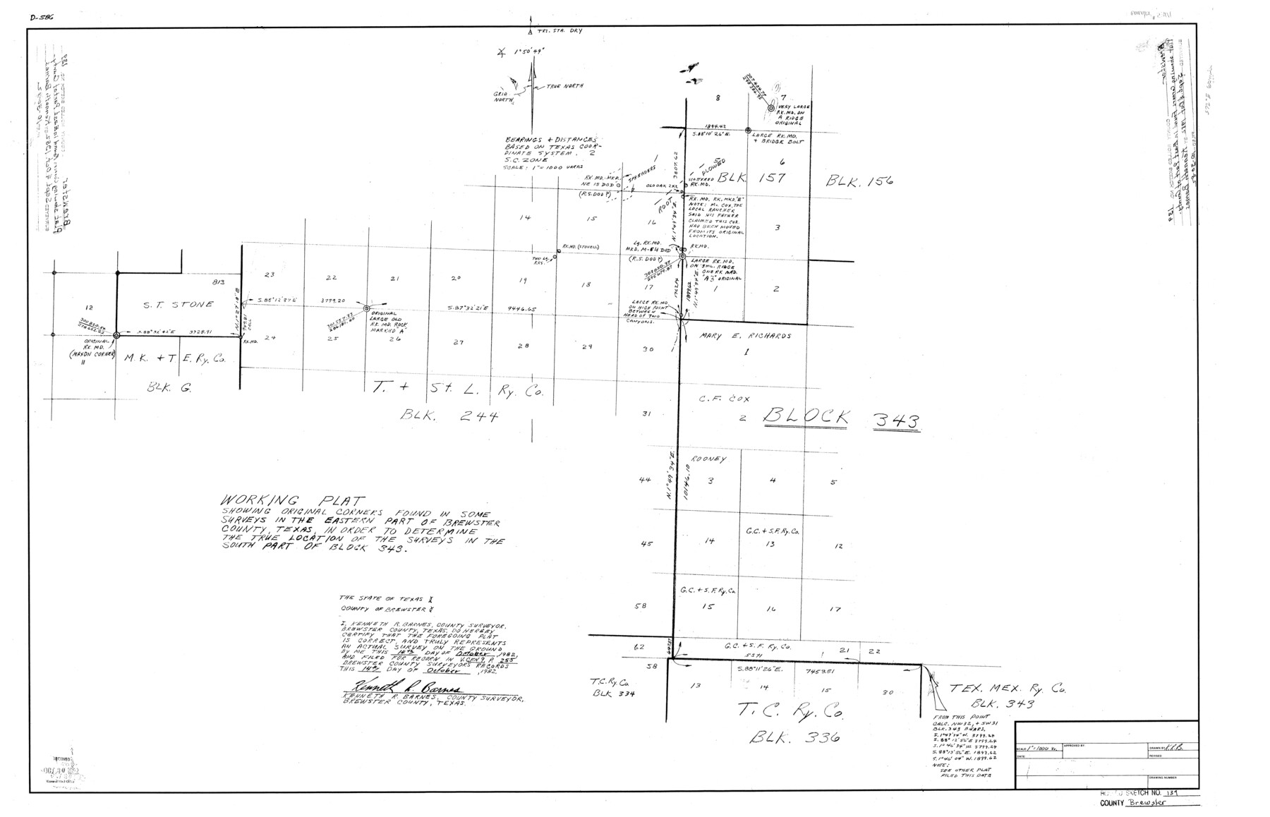
Brewster County Rolled Sketch 139
Working plat showing original corners found in some surveys in the eastern part of Brewster County, Texas in order to determine the true location of the surveys in the south part of Block 343
-
Map/Doc
5307
-
Collection
General Map Collection
-
Object Dates
1982/10/14 (Creation Date)
1982/10/30 (File Date)
-
People and Organizations
Kenneth R. Barnes (Surveyor/Engineer)
-
Counties
Brewster
-
Subjects
Surveying Rolled Sketch
-
Height x Width
24.4 x 38.0 inches
62.0 x 96.5 cm
-
Medium
mylar, print
-
Scale
1" = 1000 varas
Part of: General Map Collection
Hemphill County Sketch File 6

Print $8.00
- Digital $50.00
Hemphill County Sketch File 6
1902
Size 14.2 x 8.6 inches
Map/Doc 26299
Flight Mission No. DAG-21K, Frame 121, Matagorda County

Print $20.00
- Digital $50.00
Flight Mission No. DAG-21K, Frame 121, Matagorda County
1952
Size 18.6 x 22.3 inches
Map/Doc 86447
Angelina County Working Sketch 56

Print $20.00
- Digital $50.00
Angelina County Working Sketch 56
1993
Size 38.0 x 36.0 inches
Map/Doc 67140
Terrell County Working Sketch 22

Print $20.00
- Digital $50.00
Terrell County Working Sketch 22
1937
Size 28.8 x 26.5 inches
Map/Doc 62172
Kimble County Sketch File 35

Print $16.00
- Digital $50.00
Kimble County Sketch File 35
1963
Size 11.2 x 8.7 inches
Map/Doc 28982
Henderson County Rolled Sketch 11

Print $20.00
- Digital $50.00
Henderson County Rolled Sketch 11
1915
Size 29.7 x 42.5 inches
Map/Doc 75951
Flight Mission No. DIX-10P, Frame 175, Aransas County

Print $20.00
- Digital $50.00
Flight Mission No. DIX-10P, Frame 175, Aransas County
1956
Size 18.6 x 22.2 inches
Map/Doc 83965
St. Louis, Brownsville & Mexico

Print $40.00
- Digital $50.00
St. Louis, Brownsville & Mexico
1906
Size 21.2 x 130.5 inches
Map/Doc 89280
Kinney County Working Sketch 34

Print $20.00
- Digital $50.00
Kinney County Working Sketch 34
1963
Size 23.0 x 26.9 inches
Map/Doc 70216
Flight Mission No. CGI-3N, Frame 146, Cameron County

Print $20.00
- Digital $50.00
Flight Mission No. CGI-3N, Frame 146, Cameron County
1954
Size 18.5 x 22.1 inches
Map/Doc 84619
Flight Mission No. BRA-7M, Frame 178, Jefferson County

Print $20.00
- Digital $50.00
Flight Mission No. BRA-7M, Frame 178, Jefferson County
1953
Size 18.6 x 22.4 inches
Map/Doc 85546
Grayson County Sketch File 3

Print $4.00
- Digital $50.00
Grayson County Sketch File 3
1855
Size 12.4 x 8.4 inches
Map/Doc 24460
You may also like
Cameron County Rolled Sketch 10A

Print $71.00
- Digital $50.00
Cameron County Rolled Sketch 10A
Size 11.1 x 8.7 inches
Map/Doc 41749
Victoria County Sketch File 2

Print $7.00
- Digital $50.00
Victoria County Sketch File 2
1873
Size 10.3 x 8.4 inches
Map/Doc 39511
Harris County Working Sketch 82

Print $20.00
- Digital $50.00
Harris County Working Sketch 82
1969
Size 14.9 x 34.5 inches
Map/Doc 65974
Nueces County Sketch File 74

Print $28.00
- Digital $50.00
Nueces County Sketch File 74
1951
Size 10.1 x 15.4 inches
Map/Doc 33028
Cooke County Working Sketch 34

Print $20.00
- Digital $50.00
Cooke County Working Sketch 34
1984
Size 41.7 x 38.0 inches
Map/Doc 68271
Loving County Working Sketch 14

Print $40.00
- Digital $50.00
Loving County Working Sketch 14
1957
Size 86.7 x 35.0 inches
Map/Doc 70647
Sutton County Sketch File 9

Print $6.00
- Digital $50.00
Sutton County Sketch File 9
1893
Size 14.2 x 8.5 inches
Map/Doc 37367
Hudspeth County Working Sketch 25

Print $20.00
- Digital $50.00
Hudspeth County Working Sketch 25
1971
Size 24.6 x 28.0 inches
Map/Doc 66307
Andrews County Rolled Sketch 9

Print $20.00
- Digital $50.00
Andrews County Rolled Sketch 9
1930
Size 25.3 x 43.6 inches
Map/Doc 77160
Jefferson County Working Sketch 24

Print $20.00
- Digital $50.00
Jefferson County Working Sketch 24
1977
Size 28.4 x 44.5 inches
Map/Doc 66567
Schleicher County Sketch File 13

Print $10.00
- Digital $50.00
Schleicher County Sketch File 13
1916
Size 14.4 x 8.9 inches
Map/Doc 36493
Flight Mission No. BRA-16M, Frame 125, Jefferson County

Print $20.00
- Digital $50.00
Flight Mission No. BRA-16M, Frame 125, Jefferson County
1953
Size 18.5 x 22.6 inches
Map/Doc 85735