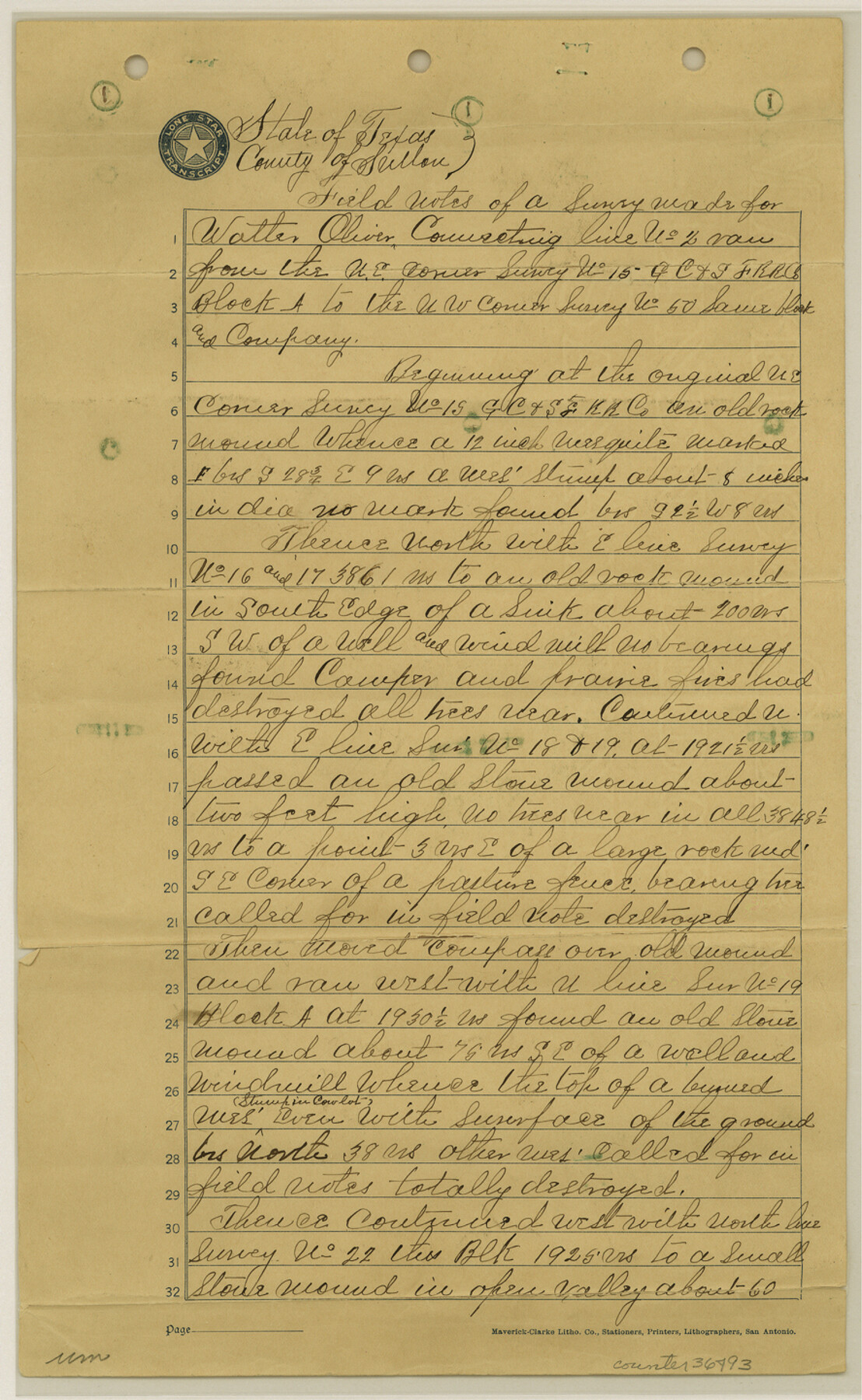
Schleicher County Sketch File 13
[Field notes of a connecting line from the NE corner of survey 14 to the NW corner of survey 50, G. C. & S. F. R.R. Co. Block A]
-
Map/Doc
36493
-
Collection
General Map Collection
-
Object Dates
3/13/1916 (Creation Date)
4/19/1916 (File Date)
3/2-13/1916 (Survey Date)
-
People and Organizations
Edgar C. Saunders (Surveyor/Engineer)
B.F. Jones (Chainman/Field Personnel)
Sifuente Sarigosa (Chainman/Field Personnel)
-
Counties
Schleicher Sutton
-
Subjects
Surveying Sketch File
-
Height x Width
14.4 x 8.9 inches
36.6 x 22.6 cm
-
Medium
paper, manuscript
Part of: General Map Collection
Rio Grande from San Juan River to the Gulf of Mexico showing Boundary between the United States and Mexico

Print $20.00
- Digital $50.00
Rio Grande from San Juan River to the Gulf of Mexico showing Boundary between the United States and Mexico
1903
Size 25.6 x 15.8 inches
Map/Doc 2065
Sketch showing progress of topographical work Laguna Madre and vicinity from Rainey Is. to Baffins Bay, Coast of Texas Sect. IX [and accompanying letter]
![72961, Sketch showing progress of topographical work Laguna Madre and vicinity from Rainey Is. to Baffins Bay, Coast of Texas Sect. IX [and accompanying letter], General Map Collection](https://historictexasmaps.com/wmedia_w700/maps/72961.tif.jpg)
Print $2.00
- Digital $50.00
Sketch showing progress of topographical work Laguna Madre and vicinity from Rainey Is. to Baffins Bay, Coast of Texas Sect. IX [and accompanying letter]
Size 11.1 x 8.7 inches
Map/Doc 72961
Aransas County Rolled Sketch 27G

Print $20.00
- Digital $50.00
Aransas County Rolled Sketch 27G
1983
Size 32.8 x 33.0 inches
Map/Doc 8421
Map of Eastland County

Print $20.00
- Digital $50.00
Map of Eastland County
1889
Size 22.9 x 21.2 inches
Map/Doc 3502
Map of Upton County

Print $20.00
- Digital $50.00
Map of Upton County
1899
Size 46.0 x 40.2 inches
Map/Doc 63087
Hamilton County Working Sketch 24

Print $20.00
- Digital $50.00
Hamilton County Working Sketch 24
1979
Size 34.7 x 33.6 inches
Map/Doc 63362
Culberson County Sketch File 13a

Print $20.00
- Digital $50.00
Culberson County Sketch File 13a
1926
Size 20.7 x 14.1 inches
Map/Doc 11265
Flight Mission No. CGI-3N, Frame 94, Cameron County

Print $20.00
- Digital $50.00
Flight Mission No. CGI-3N, Frame 94, Cameron County
1954
Size 18.6 x 22.1 inches
Map/Doc 84574
Garza County Rolled Sketch 11B

Print $20.00
- Digital $50.00
Garza County Rolled Sketch 11B
1915
Size 24.6 x 24.8 inches
Map/Doc 6001
Cameron County Rolled Sketch US

Print $20.00
- Digital $50.00
Cameron County Rolled Sketch US
1913
Size 31.1 x 26.3 inches
Map/Doc 5398
San Antonio Business District

Print $20.00
- Digital $50.00
San Antonio Business District
1935
Size 17.4 x 14.8 inches
Map/Doc 95955
Brazoria County Sketch File 29

Print $8.00
- Digital $50.00
Brazoria County Sketch File 29
1889
Size 14.0 x 8.8 inches
Map/Doc 15033
You may also like
Clay County Sketch File 13

Print $8.00
- Digital $50.00
Clay County Sketch File 13
1875
Size 8.1 x 3.7 inches
Map/Doc 18413
[Worksheets related to the Wilson Strickland survey and vicinity]
![91269, [Worksheets related to the Wilson Strickland survey and vicinity], Twichell Survey Records](https://historictexasmaps.com/wmedia_w700/maps/91269.tif.jpg)
Print $20.00
- Digital $50.00
[Worksheets related to the Wilson Strickland survey and vicinity]
Size 25.7 x 21.7 inches
Map/Doc 91269
Roberts County Working Sketch 20

Print $20.00
- Digital $50.00
Roberts County Working Sketch 20
1977
Size 25.6 x 32.9 inches
Map/Doc 63546
Plat Showing Land Owned by City of Lubbock out of Section 3, Block O

Print $20.00
- Digital $50.00
Plat Showing Land Owned by City of Lubbock out of Section 3, Block O
Size 40.4 x 31.1 inches
Map/Doc 92876

Sutton County Working Sketch 14

Print $40.00
- Digital $50.00
Sutton County Working Sketch 14
1972
Size 59.5 x 36.8 inches
Map/Doc 62357
Colorado County Working Sketch 29

Print $20.00
- Digital $50.00
Colorado County Working Sketch 29
1980
Size 15.4 x 12.4 inches
Map/Doc 68129
Flight Mission No. BRA-16M, Frame 54, Jefferson County

Print $20.00
- Digital $50.00
Flight Mission No. BRA-16M, Frame 54, Jefferson County
1953
Size 18.5 x 22.5 inches
Map/Doc 85671
Perspective Map of Fort Worth, Tex.

Print $20.00
Perspective Map of Fort Worth, Tex.
1891
Size 19.9 x 33.0 inches
Map/Doc 89083
Brewster County Rolled Sketch 152

Print $20.00
- Digital $50.00
Brewster County Rolled Sketch 152
1996
Size 28.0 x 36.5 inches
Map/Doc 5319
Flight Mission No. CUG-2P, Frame 24, Kleberg County

Print $20.00
- Digital $50.00
Flight Mission No. CUG-2P, Frame 24, Kleberg County
1956
Size 18.4 x 22.3 inches
Map/Doc 86188
Lipscomb County Sketch File 3

Print $20.00
- Digital $50.00
Lipscomb County Sketch File 3
Size 36.5 x 8.4 inches
Map/Doc 10526