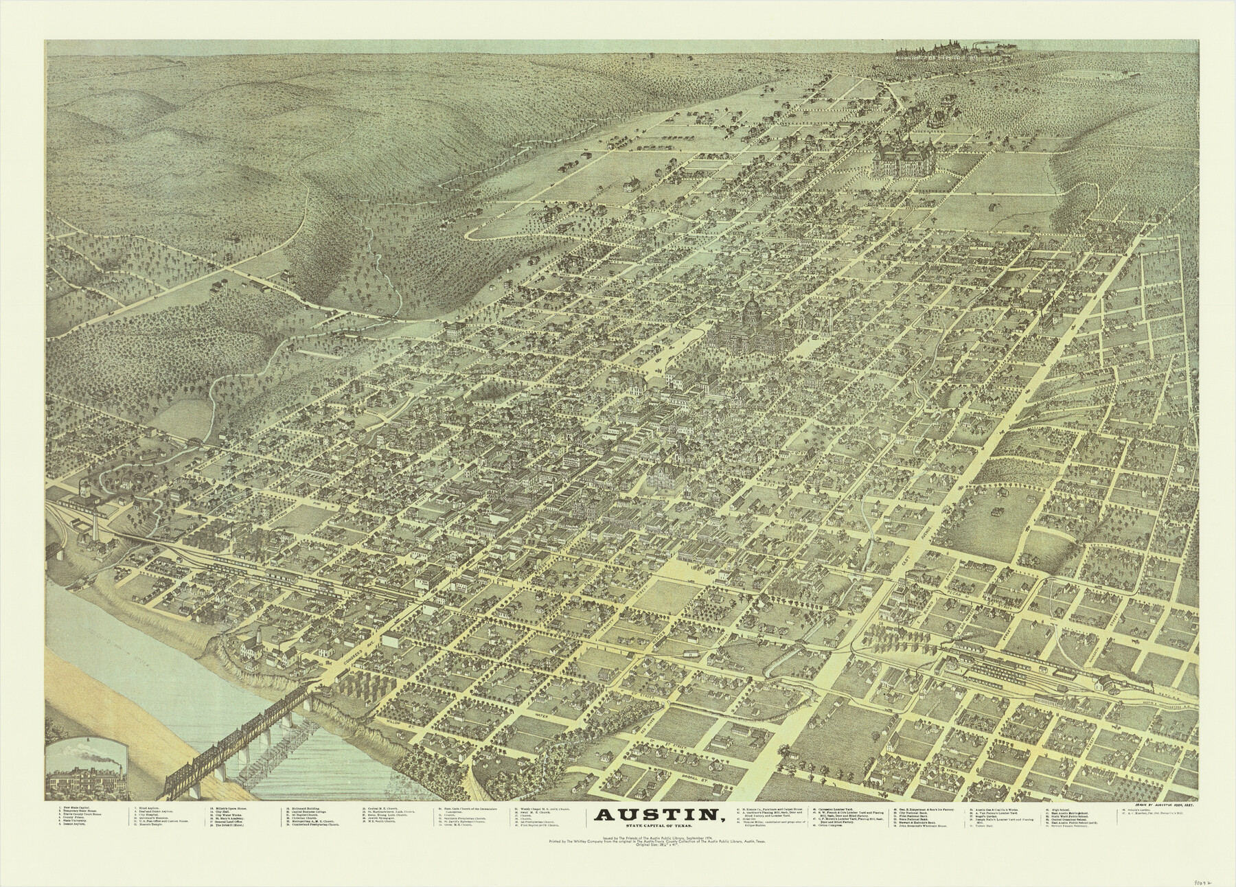
Austin, State Capital of Texas
[Bird's Eye View Map of Austin]
-
Map/Doc
90092
-
Collection
General Map Collection
-
Object Dates
1974 (Revision Date)
1887 (Creation Date)
-
People and Organizations
The Friends of the Austin Public Library (Publisher)
The Whitley Company (Printer)
Augustus Koch (Draftsman)
-
Counties
Travis
-
Subjects
Bird's Eye View City Pictorial
-
Height x Width
23.0 x 32.1 inches
58.4 x 81.5 cm
-
Medium
paper, print
-
Comments
For reference only. Copies should be obtained from the Austin History Center. Map is based on Augustus Koch's 1887 original bird's eye view map. See 89218 for a digital copy of the original map from which this was made.
-
Features
Cumberland Presbyterian Church
Central M[ethodist] E[piscopal] Church
St. Martine's Germ[an] Luth[eran] Church
Swed[ish] Evang[elical] Luth[eran] Church
Jewish Synagogue
M[ethodist] E[piscopal] South Church
First Baptist Church
Christian Church
Metropolitan A[frican] M[ethodist] E[piscopal] Church
Germ[an] M[ethodist] E[piscopal] Church
State University
St. Mary's Academy
City Hospital
Blind Asylum
Deaf and Dumb Asylum
A.C. Koerber, Pat. Pol. Pecan Co.'s Mill
Insane Asylum
Capital Business College
East Austin Public School (col'd.)
[Shoal Creek]
[Waller Creek]
Colorado River
H&TC
A&NW
East Austin Public School
Sixth Ward Public School
Central Grammar School
Austin
Steward Female Seminary
Wesley Chapel M[ethodist] E[piscopal] (col'd.) Church
Swed[ish] M[ethodist] E[piscopal] Church
First Presbyterian Church
First Baptist (col'd.) Church
Rom[an] Cath[olic] Church of the Immaculate Conception
Southern Presbyterian Church
St. David's Episcopal Church
Related maps
Austin, State Capital of Texas

Print $20.00
Austin, State Capital of Texas
1887
Size 27.5 x 40.0 inches
Map/Doc 89218
Part of: General Map Collection
El Paso County Rolled Sketch 59

Print $20.00
- Digital $50.00
El Paso County Rolled Sketch 59
1990
Size 34.5 x 36.0 inches
Map/Doc 8881

Galveston County Sketch File 28

Print $42.00
- Digital $50.00
Galveston County Sketch File 28
1913
Size 22.2 x 5.4 inches
Map/Doc 23410
Cottle County Working Sketch 4

Print $20.00
- Digital $50.00
Cottle County Working Sketch 4
1916
Size 34.3 x 31.4 inches
Map/Doc 68314
Mills County Sketch File 1b

Print $4.00
- Digital $50.00
Mills County Sketch File 1b
Size 8.6 x 9.5 inches
Map/Doc 31644
Oldham County Sketch File 13

Print $40.00
- Digital $50.00
Oldham County Sketch File 13
1902
Size 14.3 x 12.3 inches
Map/Doc 33260
Tyler County Sketch File 6-3

Print $20.00
- Digital $50.00
Tyler County Sketch File 6-3
1861
Size 20.0 x 22.1 inches
Map/Doc 12499
Garza County Rolled Sketch 3

Print $20.00
- Digital $50.00
Garza County Rolled Sketch 3
1900
Size 32.7 x 47.7 inches
Map/Doc 75937
Nueces County Rolled Sketch 4

Print $20.00
- Digital $50.00
Nueces County Rolled Sketch 4
1910
Size 39.8 x 38.5 inches
Map/Doc 9583
Van Zandt County Working Sketch 15

Print $20.00
- Digital $50.00
Van Zandt County Working Sketch 15
1982
Size 30.9 x 39.0 inches
Map/Doc 72265
Tom Green County Working Sketch 8

Print $20.00
- Digital $50.00
Tom Green County Working Sketch 8
1950
Size 24.8 x 20.9 inches
Map/Doc 69377
Rand, McNally and Co.'s Texas and Indian Territory

Print $20.00
- Digital $50.00
Rand, McNally and Co.'s Texas and Indian Territory
1883
Size 24.3 x 18.6 inches
Map/Doc 4331
You may also like
Brooks County Sketch File 1

Print $12.00
- Digital $50.00
Brooks County Sketch File 1
1923
Size 14.3 x 8.9 inches
Map/Doc 16537
Culberson County Sketch File 7

Print $8.00
- Digital $50.00
Culberson County Sketch File 7
1888
Size 14.5 x 8.8 inches
Map/Doc 20138

[Sketch showing county line between Randall and Potter Counties]
![91760, [Sketch showing county line between Randall and Potter Counties], Twichell Survey Records](https://historictexasmaps.com/wmedia_w700/maps/91760-1.tif.jpg)
Print $20.00
- Digital $50.00
[Sketch showing county line between Randall and Potter Counties]
Size 18.8 x 37.0 inches
Map/Doc 91760
Menard County Working Sketch 23

Print $20.00
- Digital $50.00
Menard County Working Sketch 23
1950
Size 45.1 x 41.3 inches
Map/Doc 70970
Kinney County Working Sketch 37

Print $20.00
- Digital $50.00
Kinney County Working Sketch 37
1971
Size 25.7 x 21.7 inches
Map/Doc 70219
Crosby County Sketch File 25

Print $12.00
- Digital $50.00
Crosby County Sketch File 25
1912
Size 11.2 x 8.7 inches
Map/Doc 20093
Atascosa County Sketch File 41a

Print $10.00
- Digital $50.00
Atascosa County Sketch File 41a
1956
Size 9.3 x 7.4 inches
Map/Doc 13841
Cass County Rolled Sketch 1

Print $20.00
- Digital $50.00
Cass County Rolled Sketch 1
1945
Size 22.1 x 23.7 inches
Map/Doc 5408
[Surveys in Robertson's Colony]
![78358, [Surveys in Robertson's Colony], General Map Collection](https://historictexasmaps.com/wmedia_w700/maps/78358.tif.jpg)
Print $20.00
- Digital $50.00
[Surveys in Robertson's Colony]
Size 18.6 x 26.5 inches
Map/Doc 78358
Calhoun County Rolled Sketch 14

Print $20.00
- Digital $50.00
Calhoun County Rolled Sketch 14
Size 21.8 x 40.2 inches
Map/Doc 5458
Upton County Sketch File D

Print $12.00
- Digital $50.00
Upton County Sketch File D
Size 13.6 x 9.0 inches
Map/Doc 38854