Upton County Sketch File D
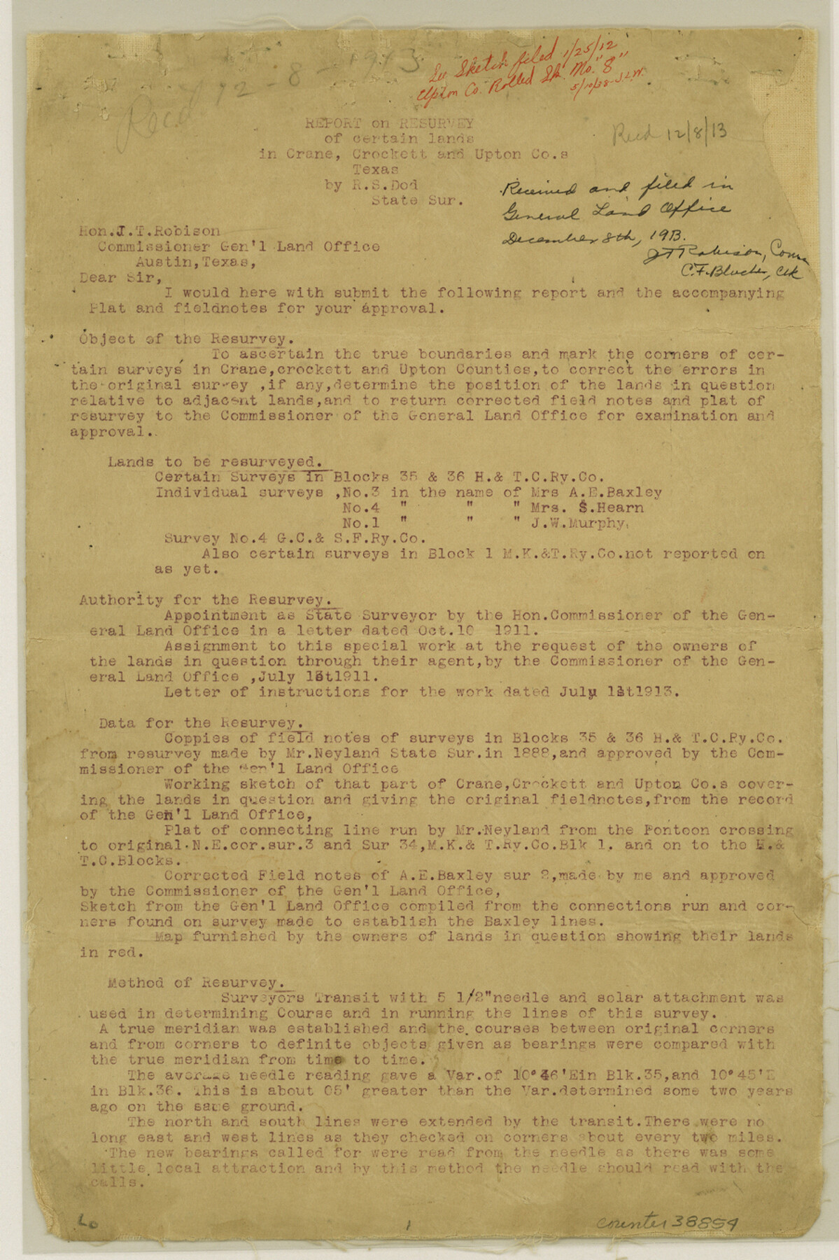
[Report regarding resurvey of lands in Crane, Crockett and Upton Counties]
-
Map/Doc
38854
-
Collection
General Map Collection
-
Object Dates
1913/12/8 (File Date)
1913/12/8 (File Date)
1888 (Survey Date)
-
People and Organizations
Neyland (Surveyor/Engineer)
A.E. Baxley (Surveyor/Engineer)
R.S. Dod (Surveyor/Engineer)
-
Counties
Upton
-
Subjects
Surveying Sketch File
-
Height x Width
13.6 x 9.0 inches
34.5 x 22.9 cm
-
Medium
paper, print
-
Features
Sugar Loaf Mountain
Pontoon [crossing]
Pontoon Bridge
Part of: General Map Collection
Flight Mission No. DQN-2K, Frame 43, Calhoun County

Print $20.00
- Digital $50.00
Flight Mission No. DQN-2K, Frame 43, Calhoun County
1953
Size 18.6 x 22.6 inches
Map/Doc 84248
Upton County Sketch File 18

Print $20.00
- Digital $50.00
Upton County Sketch File 18
1927
Size 18.9 x 29.4 inches
Map/Doc 12514
Matagorda County Sketch File 28

Print $6.00
- Digital $50.00
Matagorda County Sketch File 28
1909
Size 14.2 x 8.8 inches
Map/Doc 30812
Webb County Working Sketch 61

Print $20.00
- Digital $50.00
Webb County Working Sketch 61
1960
Size 24.7 x 28.0 inches
Map/Doc 72427
Map of Portion of Laguna Madre in Nueces & Kleberg Counties showing subdivision thereof for mineral development

Print $20.00
- Digital $50.00
Map of Portion of Laguna Madre in Nueces & Kleberg Counties showing subdivision thereof for mineral development
1937
Size 38.6 x 30.8 inches
Map/Doc 2918
Map showing the environs of Brazos Island, Texas

Print $20.00
- Digital $50.00
Map showing the environs of Brazos Island, Texas
Size 18.2 x 25.0 inches
Map/Doc 72925
Galveston County Rolled Sketch Z62

Print $20.00
- Digital $50.00
Galveston County Rolled Sketch Z62
1933
Size 34.7 x 22.7 inches
Map/Doc 5994
Hood County Working Sketch 27

Print $20.00
- Digital $50.00
Hood County Working Sketch 27
1995
Size 24.6 x 38.0 inches
Map/Doc 66221
Hardeman County Sketch File 8

Print $8.00
- Digital $50.00
Hardeman County Sketch File 8
Size 12.8 x 8.2 inches
Map/Doc 25002
Castro County Working Sketch 5

Print $20.00
- Digital $50.00
Castro County Working Sketch 5
1943
Size 11.9 x 18.3 inches
Map/Doc 67900
Flight Mission No. DCL-7C, Frame 5, Kenedy County

Print $20.00
- Digital $50.00
Flight Mission No. DCL-7C, Frame 5, Kenedy County
1943
Size 18.5 x 22.3 inches
Map/Doc 85997
Presidio de San Antonio de Bejar y Villa de San Fernando

Print $20.00
- Digital $50.00
Presidio de San Antonio de Bejar y Villa de San Fernando
1986
Size 21.8 x 26.0 inches
Map/Doc 87386
You may also like
Matagorda County Rolled Sketch 23

Print $20.00
- Digital $50.00
Matagorda County Rolled Sketch 23
1942
Size 25.0 x 23.8 inches
Map/Doc 6690
Duval County Boundary File 3m

Print $8.00
- Digital $50.00
Duval County Boundary File 3m
Size 12.8 x 8.1 inches
Map/Doc 52763
Potter County Sketch File 16

Print $38.00
- Digital $50.00
Potter County Sketch File 16
Size 13.0 x 13.9 inches
Map/Doc 34401
Victoria County Rolled Sketch 8

Print $20.00
- Digital $50.00
Victoria County Rolled Sketch 8
Size 34.2 x 27.5 inches
Map/Doc 8153
[John S. Stephens Blk. S-2, J. A. Oden Blk. 1, Lgs. 174-176]
![90188, [John S. Stephens Blk. S-2, J. A. Oden Blk. 1, Lgs. 174-176], Twichell Survey Records](https://historictexasmaps.com/wmedia_w700/maps/90188-1.tif.jpg)
Print $20.00
- Digital $50.00
[John S. Stephens Blk. S-2, J. A. Oden Blk. 1, Lgs. 174-176]
1913
Size 23.5 x 27.0 inches
Map/Doc 90188
Jeff Davis County Sketch File 27

Print $20.00
- Digital $50.00
Jeff Davis County Sketch File 27
1915
Size 18.8 x 25.5 inches
Map/Doc 11862
Stonewall County Sketch File 10

Print $10.00
- Digital $50.00
Stonewall County Sketch File 10
1899
Size 11.2 x 8.6 inches
Map/Doc 37232
Flight Mission No. DAG-22K, Frame 77, Matagorda County

Print $20.00
- Digital $50.00
Flight Mission No. DAG-22K, Frame 77, Matagorda County
1953
Size 18.6 x 22.4 inches
Map/Doc 86464
Map of Houston Heights, Harris County, Texas owned by the Omaha & South Texas Land Co., Houston, Texas

Print $20.00
- Digital $50.00
Map of Houston Heights, Harris County, Texas owned by the Omaha & South Texas Land Co., Houston, Texas
1891
Size 16.3 x 10.7 inches
Map/Doc 94458
Val Verde County Rolled Sketch 67

Print $20.00
- Digital $50.00
Val Verde County Rolled Sketch 67
1958
Size 24.5 x 31.6 inches
Map/Doc 8130
From Citizens Living in Washington County for the Creation of a New County to be Called Washington, Undated

Print $20.00
From Citizens Living in Washington County for the Creation of a New County to be Called Washington, Undated
2020
Size 17.0 x 21.7 inches
Map/Doc 96406
Hays County Rolled Sketch 22

Print $20.00
- Digital $50.00
Hays County Rolled Sketch 22
1924
Size 19.4 x 20.6 inches
Map/Doc 6178