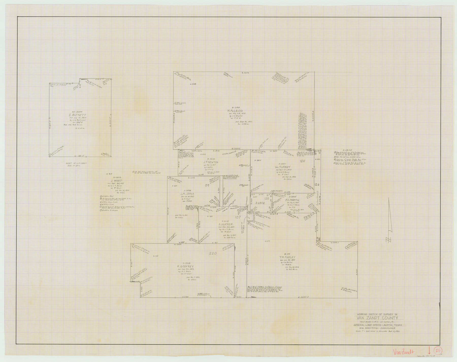
Van Zandt County Working Sketch 15
- 
                          Map/Doc72265
- 
                            CollectionGeneral Map Collection
- 
                            Object Dates9/27/1982 (Creation Date)
- 
                            People and OrganizationsEarl Alexander (Draftsman)
- 
                            CountiesVan Zandt
- 
                            SubjectsSurveying Working Sketch
- 
                            Height x Width30.9 x 39.0 inches78.5 x 99.1 cm
- 
                            Scale1" = 300 varas
Part of: General Map Collection
            Comal County Working Sketch 11


                                            Print $20.00                    
                                             -                         Digital $50.00                                    
                Comal County Working Sketch 11
1978
Size 33.2 x 35.2 inches
                                Map/Doc 68177
            
            Culberson County Working Sketch 20


                                            Print $40.00                    
                                             -                         Digital $50.00                                    
                Culberson County Working Sketch 20
1935
Size 76.6 x 44.3 inches
                                Map/Doc 68472
            
            Map of Robertson County


                                            Print $40.00                    
                                             -                         Digital $50.00                                    
                Map of Robertson County
1839
Size 56.2 x 33.0 inches
                                Map/Doc 4656
            
            Lampasas County Sketch File A1


                                            Print $2.00                    
                                             -                         Digital $50.00                                    
                Lampasas County Sketch File A1
Size 6.8 x 6.3 inches
                                Map/Doc 29385
            
            Montgomery County Working Sketch 4


                                            Print $20.00                    
                                             -                         Digital $50.00                                    
                Montgomery County Working Sketch 4
1926
Size 20.9 x 22.2 inches
                                Map/Doc 71110
            
            San Bernard River, Texas showing possible connection with Brazos River and part of possible connection with Matagorda Bay for a Light Draft Navigation


                                            Print $40.00                    
                                             -                         Digital $50.00                                    
                San Bernard River, Texas showing possible connection with Brazos River and part of possible connection with Matagorda Bay for a Light Draft Navigation
Size 17.2 x 56.1 inches
                                Map/Doc 96561
            
            Trinity River, Five Mile Creek Sheet


                                            Print $20.00                    
                                             -                         Digital $50.00                                    
                Trinity River, Five Mile Creek Sheet
1923
Size 20.0 x 40.4 inches
                                Map/Doc 65197
            
            Matagorda County NRC Article 33.136 Location Key Sheet


                                            Print $20.00                    
                                             -                         Digital $50.00                                    
                Matagorda County NRC Article 33.136 Location Key Sheet
1973
Size 27.0 x 23.0 inches
                                Map/Doc 88832
            
            Dickens County Sketch File 33


                                            Print $10.00                    
                                             -                         Digital $50.00                                    
                Dickens County Sketch File 33
1947
Size 14.5 x 9.1 inches
                                Map/Doc 21025
            
            Milam County Boundary File 65a


                                            Print $40.00                    
                                             -                         Digital $50.00                                    
                Milam County Boundary File 65a
Size 17.2 x 30.4 inches
                                Map/Doc 57256
            
            Flight Mission No. DAG-24K, Frame 133, Matagorda County


                                            Print $20.00                    
                                             -                         Digital $50.00                                    
                Flight Mission No. DAG-24K, Frame 133, Matagorda County
1953
Size 18.5 x 22.3 inches
                                Map/Doc 86551
            
            Flight Mission No. BRE-2P, Frame 102, Nueces County


                                            Print $20.00                    
                                             -                         Digital $50.00                                    
                Flight Mission No. BRE-2P, Frame 102, Nueces County
1956
Size 18.4 x 22.2 inches
                                Map/Doc 86787
            You may also like
            Santa Rosa, the Saint of Roses - Lower Rio Grande Valley


            Santa Rosa, the Saint of Roses - Lower Rio Grande Valley
1920
Map/Doc 96734
            
            [R. M. Thompson, Block A and Part of Jones County School Land]
            
                                    ![91222, [R. M. Thompson, Block A and Part of Jones County School Land], Twichell Survey Records](https://historictexasmaps.com/wmedia_w700/maps/91222-1.tif.jpg) 


    ![91222, [R. M. Thompson, Block A and Part of Jones County School Land], Twichell Survey Records](https://historictexasmaps.com/wmedia_w700/maps/91222-1.tif.jpg) 
                                
            
                                            Print $20.00                    
                                             -                         Digital $50.00                                    
                [R. M. Thompson, Block A and Part of Jones County School Land]
Size 10.4 x 20.9 inches
                                Map/Doc 91222
            
            Padre Island National Seashore


                                            Print $4.00                    
                                             -                         Digital $50.00                                    
                Padre Island National Seashore
Size 16.1 x 22.4 inches
                                Map/Doc 60541
            
            Map Showing Division Line Between Chapman and Mills' Lands


                                            Print $20.00                    
                                             -                         Digital $50.00                                    
                Map Showing Division Line Between Chapman and Mills' Lands
Size 32.5 x 31.6 inches
                                Map/Doc 92848
            
            Lampasas County Boundary File 5


                                            Print $16.00                    
                                             -                         Digital $50.00                                    
                Lampasas County Boundary File 5
Size 11.1 x 8.7 inches
                                Map/Doc 56128
            
            Organizations for the Development of Texas Rivers


                                            Print $20.00                    
                                    
                Organizations for the Development of Texas Rivers
1938
Size 34.4 x 44.8 inches
                                Map/Doc 76307
            
            Eastland County


                                            Print $20.00                    
                                             -                         Digital $50.00                                    
                Eastland County
1945
Size 41.8 x 42.0 inches
                                Map/Doc 77268
            
            Johnson County Boundary File 2a


                                            Print $22.00                    
                                             -                         Digital $50.00                                    
                Johnson County Boundary File 2a
Size 9.0 x 8.3 inches
                                Map/Doc 55566
            
            [East half of Travis County]
            
                                    ![75802, [East half of Travis County], Maddox Collection](https://historictexasmaps.com/wmedia_w700/maps/75802.tif.jpg) 


    ![75802, [East half of Travis County], Maddox Collection](https://historictexasmaps.com/wmedia_w700/maps/75802.tif.jpg) 
                                
            
                                            Print $20.00                    
                                             -                         Digital $50.00                                    
                [East half of Travis County]
Size 42.5 x 29.8 inches
                                Map/Doc 75802
            
            Pecos County Rolled Sketch 130


                                            Print $20.00                    
                                             -                         Digital $50.00                                    
                Pecos County Rolled Sketch 130
1950
Size 20.1 x 27.7 inches
                                Map/Doc 7268
            
            Flight Mission No. BRA-6M, Frame 147, Jefferson County


                                            Print $20.00                    
                                             -                         Digital $50.00                                    
                Flight Mission No. BRA-6M, Frame 147, Jefferson County
1953
Size 18.6 x 22.4 inches
                                Map/Doc 85448
            
            Refugio County Working Sketch 4


                                            Print $20.00                    
                                             -                         Digital $50.00                                    
                Refugio County Working Sketch 4
1937
Size 33.2 x 31.4 inches
                                Map/Doc 63513
            