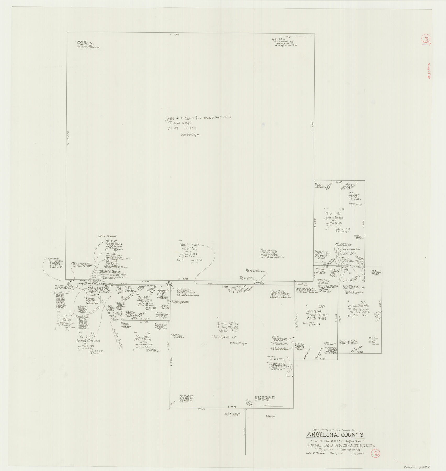
Angelina County Working Sketch 56
-
Map/Doc
67140
-
Collection
General Map Collection
-
Object Dates
11/4/1993 (Creation Date)
-
People and Organizations
Joan Kilpatrick (Draftsman)
Garry Mauro (GLO Commissioner)
-
Counties
Angelina
-
Subjects
Surveying Working Sketch
-
Height x Width
38.0 x 36.0 inches
96.5 x 91.4 cm
-
Scale
1" = 500 varas
-
Comments
Surveys located about 10 miles North 70 degrees West from Lufkin, Texas.
Part of: General Map Collection
Hidalgo County Working Sketch 1

Print $20.00
- Digital $50.00
Hidalgo County Working Sketch 1
1939
Size 24.8 x 21.4 inches
Map/Doc 66178
Bee County Sketch File 1a

Print $12.00
- Digital $50.00
Bee County Sketch File 1a
1846
Size 9.8 x 6.5 inches
Map/Doc 14359
Bosque County Rolled Sketch 1

Print $20.00
- Digital $50.00
Bosque County Rolled Sketch 1
1978
Size 36.4 x 38.6 inches
Map/Doc 8452
Map of Starr County

Print $20.00
- Digital $50.00
Map of Starr County
1896
Size 43.7 x 26.9 inches
Map/Doc 4050
Caldwell County Working Sketch 6

Print $20.00
- Digital $50.00
Caldwell County Working Sketch 6
1958
Size 21.8 x 26.3 inches
Map/Doc 67836
Coleman County Rolled Sketch 2

Print $20.00
- Digital $50.00
Coleman County Rolled Sketch 2
Size 18.3 x 24.9 inches
Map/Doc 5528
DeWitt County Working Sketch 8

Print $20.00
- Digital $50.00
DeWitt County Working Sketch 8
1979
Size 35.7 x 41.9 inches
Map/Doc 68598

Bastrop County Sketch File 9

Print $40.00
- Digital $50.00
Bastrop County Sketch File 9
1943
Size 46.5 x 20.6 inches
Map/Doc 10320
Crane County Sketch File 9

Print $20.00
- Digital $50.00
Crane County Sketch File 9
1926
Size 21.7 x 34.1 inches
Map/Doc 11208
Karnes County Working Sketch 2

Print $20.00
- Digital $50.00
Karnes County Working Sketch 2
1939
Size 18.8 x 20.0 inches
Map/Doc 66650
Henderson County Rolled Sketch 11

Print $20.00
- Digital $50.00
Henderson County Rolled Sketch 11
1915
Size 29.4 x 42.4 inches
Map/Doc 75957
You may also like
Kaufman County

Print $40.00
- Digital $50.00
Kaufman County
1942
Size 48.7 x 39.5 inches
Map/Doc 73202
[Southern Pacific Rail Road Co. Blocks 15 and 16 in Mitchell, Sterling and Coke Counties]
![91838, [Southern Pacific Rail Road Co. Blocks 15 and 16 in Mitchell, Sterling and Coke Counties], Twichell Survey Records](https://historictexasmaps.com/wmedia_w700/maps/91838-1.tif.jpg)
Print $20.00
- Digital $50.00
[Southern Pacific Rail Road Co. Blocks 15 and 16 in Mitchell, Sterling and Coke Counties]
Size 34.5 x 29.2 inches
Map/Doc 91838
Scurry County Rolled Sketch 1

Print $40.00
- Digital $50.00
Scurry County Rolled Sketch 1
Size 70.5 x 44.9 inches
Map/Doc 9910
Dimmit County Sketch File 45

Print $20.00
- Digital $50.00
Dimmit County Sketch File 45
1905
Size 24.9 x 25.5 inches
Map/Doc 11355
Sketch of Maneuver Tract

Print $20.00
- Digital $50.00
Sketch of Maneuver Tract
1870
Size 18.5 x 14.4 inches
Map/Doc 2184
Mason County Boundary File 2

Print $16.00
- Digital $50.00
Mason County Boundary File 2
Size 9.1 x 8.3 inches
Map/Doc 56830
Map of parts of Texas, Mexico and New Mexico

Print $4.00
- Digital $50.00
Map of parts of Texas, Mexico and New Mexico
1877
Size 18.1 x 21.8 inches
Map/Doc 65403
Dallas County Rolled Sketch 1

Print $40.00
- Digital $50.00
Dallas County Rolled Sketch 1
1938
Size 22.7 x 78.5 inches
Map/Doc 8765
Webb County Rolled Sketch 24

Print $20.00
- Digital $50.00
Webb County Rolled Sketch 24
1930
Size 33.0 x 23.0 inches
Map/Doc 8184
Brewster County Rolled Sketch A

Print $40.00
- Digital $50.00
Brewster County Rolled Sketch A
Size 26.7 x 94.8 inches
Map/Doc 8925
Ector County Sketch File 5

Print $6.00
- Digital $50.00
Ector County Sketch File 5
1939
Size 9.1 x 14.5 inches
Map/Doc 21637
Montague County Working Sketch 5

Print $20.00
- Digital $50.00
Montague County Working Sketch 5
1920
Size 24.9 x 20.9 inches
Map/Doc 71071