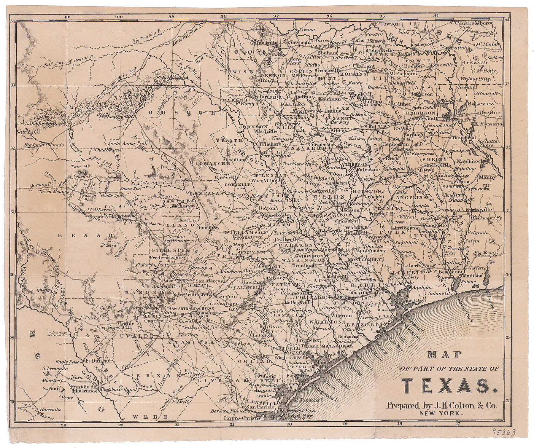
Map of part of the State of Texas
-
Map/Doc
95363
-
Collection
General Map Collection
-
Object Dates
1857 (Creation Date)
-
People and Organizations
J.H. Colton & Co. (Publisher)
-
Subjects
State of Texas
-
Height x Width
8.0 x 9.6 inches
20.3 x 24.4 cm
-
Medium
paper, etching/engraving/lithograph
Part of: General Map Collection
Crane County Working Sketch 19

Print $20.00
- Digital $50.00
Crane County Working Sketch 19
1958
Size 28.6 x 38.8 inches
Map/Doc 68296
Kent County Working Sketch 5

Print $40.00
- Digital $50.00
Kent County Working Sketch 5
1950
Size 36.7 x 50.1 inches
Map/Doc 70012
Sutton County Working Sketch 53

Print $20.00
- Digital $50.00
Sutton County Working Sketch 53
1957
Size 36.1 x 37.5 inches
Map/Doc 62396
Cherokee County Sketch File 34

Print $12.00
- Digital $50.00
Cherokee County Sketch File 34
1954
Size 11.2 x 8.9 inches
Map/Doc 18198
Flight Mission No. CUI-1H, Frame 140, Milam County

Print $20.00
- Digital $50.00
Flight Mission No. CUI-1H, Frame 140, Milam County
1951
Size 18.4 x 22.2 inches
Map/Doc 86606
Culberson County Rolled Sketch 14

Print $20.00
- Digital $50.00
Culberson County Rolled Sketch 14
1902
Size 35.3 x 34.6 inches
Map/Doc 8743
Liberty County Sketch File 65

Print $4.00
- Digital $50.00
Liberty County Sketch File 65
1895
Size 11.0 x 8.7 inches
Map/Doc 30128
Flight Mission No. DQO-8K, Frame 55, Galveston County

Print $20.00
- Digital $50.00
Flight Mission No. DQO-8K, Frame 55, Galveston County
1952
Size 18.7 x 22.5 inches
Map/Doc 85162
Comal County Sketch File 13

Print $8.00
- Digital $50.00
Comal County Sketch File 13
1866
Size 9.5 x 14.9 inches
Map/Doc 19026
Val Verde County Sketch File 28

Print $20.00
- Digital $50.00
Val Verde County Sketch File 28
Size 29.9 x 25.1 inches
Map/Doc 12573
Crockett County Rolled Sketch RC

Print $50.00
- Digital $50.00
Crockett County Rolled Sketch RC
1935
Size 43.2 x 31.1 inches
Map/Doc 8702
Flight Mission No. DQO-3K, Frame 24, Galveston County

Print $20.00
- Digital $50.00
Flight Mission No. DQO-3K, Frame 24, Galveston County
1952
Size 18.7 x 22.4 inches
Map/Doc 85065
You may also like
Motley County Sketch File 20 (S)

Print $14.00
- Digital $50.00
Motley County Sketch File 20 (S)
Size 7.2 x 8.7 inches
Map/Doc 32196
North Sulphur River, Bartley Gin Sheet

Print $20.00
- Digital $50.00
North Sulphur River, Bartley Gin Sheet
1928
Size 21.1 x 42.5 inches
Map/Doc 65173
Reeves County Sketch File 1

Print $10.00
- Digital $50.00
Reeves County Sketch File 1
Size 9.0 x 15.8 inches
Map/Doc 35176
Williamson County Sketch File 25

Print $14.00
- Digital $50.00
Williamson County Sketch File 25
1878
Size 8.9 x 8.3 inches
Map/Doc 40361
San Augustine County Sketch File 11

Print $4.00
San Augustine County Sketch File 11
Size 12.1 x 7.7 inches
Map/Doc 35654
Block D14 Terry County

Print $20.00
- Digital $50.00
Block D14 Terry County
Size 17.0 x 17.7 inches
Map/Doc 92416
Newton County Working Sketch 42

Print $20.00
- Digital $50.00
Newton County Working Sketch 42
1981
Size 26.4 x 22.5 inches
Map/Doc 71288
Edwards County Sketch File 1

Print $10.00
- Digital $50.00
Edwards County Sketch File 1
Size 9.2 x 7.0 inches
Map/Doc 21672
Mills County Working Sketch 2

Print $20.00
- Digital $50.00
Mills County Working Sketch 2
1904
Size 12.7 x 15.8 inches
Map/Doc 71032
DeWitt County Rolled Sketch 1

Print $20.00
- Digital $50.00
DeWitt County Rolled Sketch 1
1940
Size 40.5 x 39.5 inches
Map/Doc 8777
Harris County Working Sketch 43

Print $20.00
- Digital $50.00
Harris County Working Sketch 43
1940
Size 26.8 x 22.1 inches
Map/Doc 65935
Frio County Working Sketch 25

Print $40.00
- Digital $50.00
Frio County Working Sketch 25
1989
Size 35.4 x 50.0 inches
Map/Doc 69299