Liberty County Sketch File 65
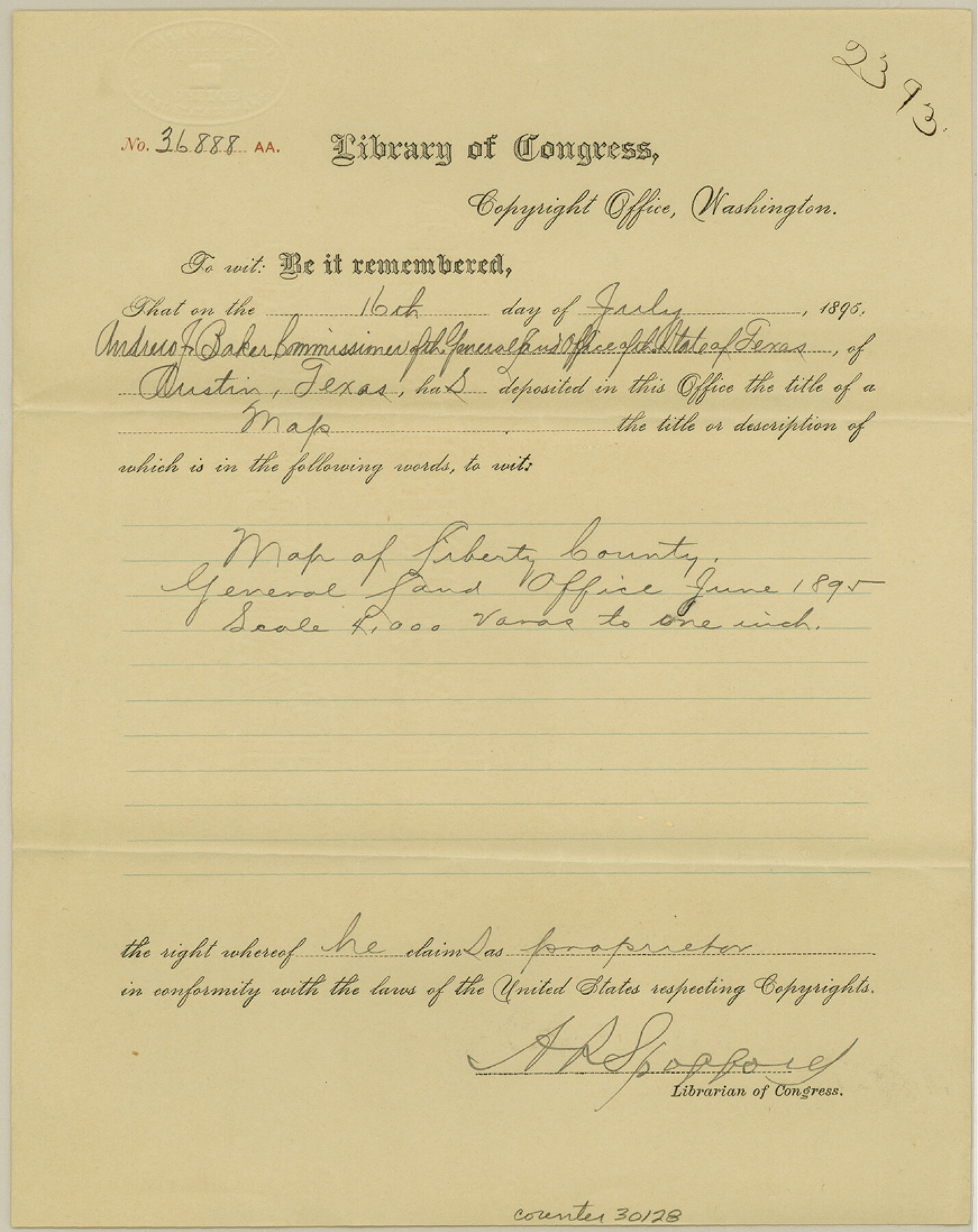
[Copyright certificate from the Library of Congress for the GLO Liberty County map]
-
Map/Doc
30128
-
Collection
General Map Collection
-
Object Dates
7/16/1895 (Creation Date)
8/6/1895 (File Date)
-
Counties
Liberty
-
Subjects
Surveying Sketch File
-
Height x Width
11.0 x 8.7 inches
27.9 x 22.1 cm
-
Medium
paper, print with manuscript additions
-
Scale
1:4000
Part of: General Map Collection
Uvalde County Working Sketch 63

Print $20.00
- Digital $50.00
Uvalde County Working Sketch 63
1995
Size 26.8 x 42.0 inches
Map/Doc 72133
Dimmit County Rolled Sketch 14

Print $40.00
- Digital $50.00
Dimmit County Rolled Sketch 14
1945
Size 56.6 x 36.0 inches
Map/Doc 8797
Waller County Sketch File 3

Print $4.00
- Digital $50.00
Waller County Sketch File 3
Size 13.0 x 8.4 inches
Map/Doc 39598
Wise County Sketch File 48

Print $10.00
- Digital $50.00
Wise County Sketch File 48
1922
Size 14.2 x 8.7 inches
Map/Doc 40613
Angelina County Working Sketch 8

Print $20.00
- Digital $50.00
Angelina County Working Sketch 8
1920
Size 19.1 x 15.0 inches
Map/Doc 67089
Henderson County Working Sketch 19

Print $20.00
- Digital $50.00
Henderson County Working Sketch 19
1947
Size 18.6 x 20.3 inches
Map/Doc 66152
Houston County Rolled Sketch 10

Print $20.00
- Digital $50.00
Houston County Rolled Sketch 10
1988
Size 31.9 x 25.3 inches
Map/Doc 6230
Flight Mission No. BRA-6M, Frame 89, Jefferson County

Print $20.00
- Digital $50.00
Flight Mission No. BRA-6M, Frame 89, Jefferson County
1953
Size 18.6 x 22.4 inches
Map/Doc 85432
Rusk County Sketch File 27a

Print $10.00
Rusk County Sketch File 27a
1936
Size 14.2 x 8.8 inches
Map/Doc 35532
Oldham County Boundary File 1b

Print $48.00
- Digital $50.00
Oldham County Boundary File 1b
Size 14.0 x 8.5 inches
Map/Doc 57747
Val Verde County Sketch File 32

Print $20.00
- Digital $50.00
Val Verde County Sketch File 32
Size 45.1 x 20.1 inches
Map/Doc 10420
Palo Pinto County Boundary File 2

Print $18.00
- Digital $50.00
Palo Pinto County Boundary File 2
Size 9.1 x 3.9 inches
Map/Doc 57791
You may also like
Bexar County Sketch File 47

Print $40.00
- Digital $50.00
Bexar County Sketch File 47
1896
Size 9.9 x 19.6 inches
Map/Doc 10925
Sutton County Rolled Sketch 40

Print $20.00
- Digital $50.00
Sutton County Rolled Sketch 40
1930
Size 25.9 x 28.3 inches
Map/Doc 7882
Liberty County Rolled Sketch C

Print $20.00
- Digital $50.00
Liberty County Rolled Sketch C
1941
Size 39.5 x 35.4 inches
Map/Doc 9571
Fractional Township No. 7 South Range No. 5 West of the Indian Meridian, Indian Territory

Print $20.00
- Digital $50.00
Fractional Township No. 7 South Range No. 5 West of the Indian Meridian, Indian Territory
1898
Size 19.1 x 24.4 inches
Map/Doc 75189
Washington County Sketch File 6

Print $20.00
- Digital $50.00
Washington County Sketch File 6
1901
Size 24.7 x 26.0 inches
Map/Doc 12602
[Missouri, Kansas & Texas Line Map through Bastrop County]
![64028, [Missouri, Kansas & Texas Line Map through Bastrop County], General Map Collection](https://historictexasmaps.com/wmedia_w700/maps/64028.tif.jpg)
Print $40.00
- Digital $50.00
[Missouri, Kansas & Texas Line Map through Bastrop County]
1916
Size 26.2 x 121.8 inches
Map/Doc 64028
La Salle County Sketch File 24

Print $4.00
- Digital $50.00
La Salle County Sketch File 24
1877
Size 9.2 x 6.1 inches
Map/Doc 29547
Runnels County Rolled Sketch 50

Print $20.00
- Digital $50.00
Runnels County Rolled Sketch 50
Size 31.3 x 26.7 inches
Map/Doc 7535
Atascosa County Boundary File 6

Print $34.00
- Digital $50.00
Atascosa County Boundary File 6
Size 9.1 x 23.0 inches
Map/Doc 50205
Webb County Sketch File 1a

Print $20.00
- Digital $50.00
Webb County Sketch File 1a
1871
Size 23.3 x 18.0 inches
Map/Doc 12623
Map of Zavalla County

Print $20.00
- Digital $50.00
Map of Zavalla County
1862
Size 24.2 x 20.5 inches
Map/Doc 4180
[Cotton Belt, St. Louis Southwestern Railway of Texas, Alignment through Smith County]
![64374, [Cotton Belt, St. Louis Southwestern Railway of Texas, Alignment through Smith County], General Map Collection](https://historictexasmaps.com/wmedia_w700/maps/64374.tif.jpg)
Print $20.00
- Digital $50.00
[Cotton Belt, St. Louis Southwestern Railway of Texas, Alignment through Smith County]
1903
Size 21.5 x 29.3 inches
Map/Doc 64374