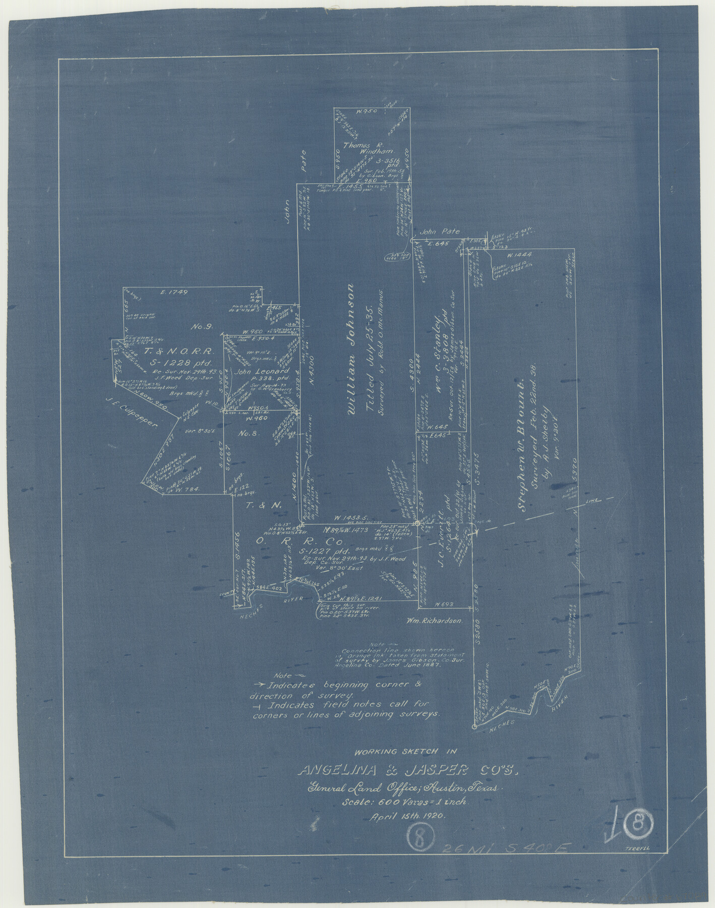
Angelina County Working Sketch 8
Working Sketch in Angelina and Jasper Counties
-
Map/Doc
67089
-
Collection
General Map Collection
-
Object Dates
4/15/1920 (Creation Date)
-
Counties
Angelina Jasper
-
Subjects
Surveying Working Sketch
-
Height x Width
19.1 x 15.0 inches
48.5 x 38.1 cm
-
Scale
1" = 600 varas
-
Comments
Surveys located about 26 miles South 40 degrees East of Lufkin, Texas.
Part of: General Map Collection
Smith County Working Sketch 7

Print $20.00
- Digital $50.00
Smith County Working Sketch 7
1941
Size 27.2 x 20.8 inches
Map/Doc 63892
Rusk County Sketch File 35

Print $6.00
Rusk County Sketch File 35
1950
Size 11.3 x 8.8 inches
Map/Doc 35573
Bee County Working Sketch 19

Print $20.00
- Digital $50.00
Bee County Working Sketch 19
1980
Size 17.3 x 11.9 inches
Map/Doc 67269


Hunt County Sketch File 5a

Print $6.00
- Digital $50.00
Hunt County Sketch File 5a
1852
Size 10.2 x 15.8 inches
Map/Doc 27093
Hidalgo County Working Sketch 4

Print $20.00
- Digital $50.00
Hidalgo County Working Sketch 4
1938
Size 43.1 x 39.6 inches
Map/Doc 66181
Panola County Sketch File 21

Print $10.00
- Digital $50.00
Panola County Sketch File 21
Size 11.2 x 8.7 inches
Map/Doc 33487
Liberty County Working Sketch 46

Print $20.00
- Digital $50.00
Liberty County Working Sketch 46
1953
Size 18.6 x 37.6 inches
Map/Doc 70505
Kinney County Sketch File 31

Print $40.00
- Digital $50.00
Kinney County Sketch File 31
1934
Size 15.3 x 13.6 inches
Map/Doc 29176
Matagorda County NRC Article 33.136 Sketch 2

Print $26.00
- Digital $50.00
Matagorda County NRC Article 33.136 Sketch 2
2005
Size 22.1 x 34.8 inches
Map/Doc 83395
Flight Mission No. DAG-17K, Frame 139, Matagorda County

Print $20.00
- Digital $50.00
Flight Mission No. DAG-17K, Frame 139, Matagorda County
1952
Size 18.5 x 22.3 inches
Map/Doc 86356
You may also like
Orange County NRC Article 33.136 Sketch 1

Print $20.00
- Digital $50.00
Orange County NRC Article 33.136 Sketch 1
2004
Size 23.8 x 34.5 inches
Map/Doc 81979
[Surveys in Williamson County]
![78374, [Surveys in Williamson County], General Map Collection](https://historictexasmaps.com/wmedia_w700/maps/78374.tif.jpg)
Print $2.00
- Digital $50.00
[Surveys in Williamson County]
1846
Size 9.2 x 11.8 inches
Map/Doc 78374
Bell County Working Sketch 16

Print $20.00
- Digital $50.00
Bell County Working Sketch 16
1983
Size 46.5 x 35.4 inches
Map/Doc 67356
Panola County Working Sketch 32

Print $20.00
- Digital $50.00
Panola County Working Sketch 32
1982
Map/Doc 71441
Jasper County Working Sketch Graphic Index

Print $20.00
- Digital $50.00
Jasper County Working Sketch Graphic Index
1946
Size 47.9 x 41.0 inches
Map/Doc 76591
El Paso County Rolled Sketch 54

Print $20.00
- Digital $50.00
El Paso County Rolled Sketch 54
1980
Size 30.4 x 42.8 inches
Map/Doc 44539
Subdivision of Halsell Cattle Company's Sod House Pasture Situated in Lamb County, Texas

Print $20.00
- Digital $50.00
Subdivision of Halsell Cattle Company's Sod House Pasture Situated in Lamb County, Texas
Size 37.3 x 28.2 inches
Map/Doc 92169
Terrell County Working Sketch 39

Print $20.00
- Digital $50.00
Terrell County Working Sketch 39
1951
Size 26.8 x 40.4 inches
Map/Doc 62132
Neches River, Texas Agricultural Experiment Station

Print $4.00
- Digital $50.00
Neches River, Texas Agricultural Experiment Station
1940
Size 21.7 x 20.6 inches
Map/Doc 65080
Brewster County Rolled Sketch 60

Print $40.00
- Digital $50.00
Brewster County Rolled Sketch 60
Size 36.7 x 50.8 inches
Map/Doc 9200
Flight Mission No. CUG-3P, Frame 192, Kleberg County

Print $20.00
- Digital $50.00
Flight Mission No. CUG-3P, Frame 192, Kleberg County
1956
Size 18.4 x 22.2 inches
Map/Doc 86296
Wilson County Boundary File 4

Print $26.00
- Digital $50.00
Wilson County Boundary File 4
Size 8.9 x 7.8 inches
Map/Doc 60096