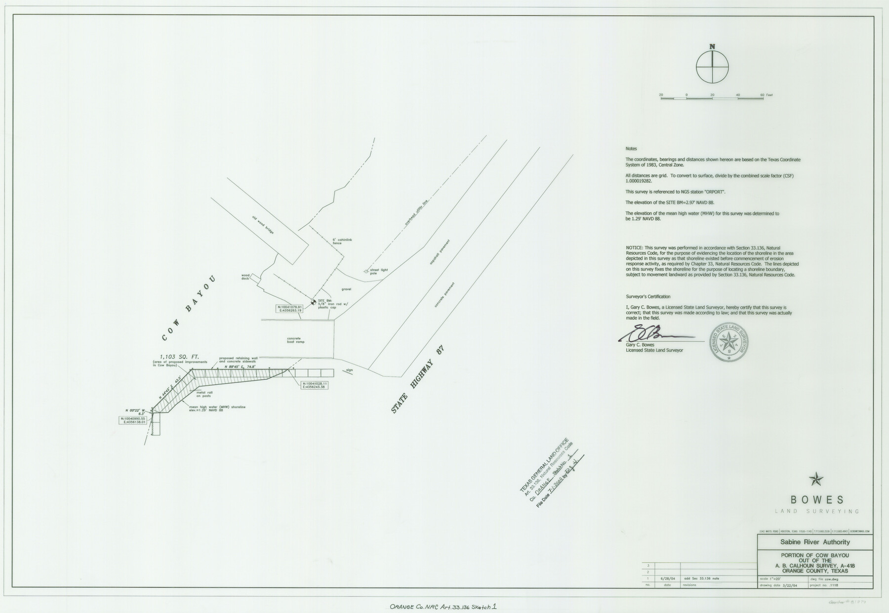
Orange County NRC Article 33.136 Sketch 1
A Portion of Cow Bayou out of the A. B. Calhoun Survey, Abstract 418
-
Map/Doc
81979
-
Collection
General Map Collection
-
Object Dates
2004/6/28 (Creation Date)
2004/7/1 (File Date)
-
People and Organizations
Bowes Land Surveying (Publisher)
Bowes Land Surveying (Printer)
Gary C. Bowes (Surveyor/Engineer)
-
Counties
Orange
-
Subjects
Surveying CBS
-
Height x Width
23.8 x 34.5 inches
60.5 x 87.6 cm
-
Medium
mylar, print
-
Comments
Survey located about six miles South 55 degrees West of Orange, Texas.
Part of: General Map Collection
Kent County Rolled Sketch 4

Print $20.00
- Digital $50.00
Kent County Rolled Sketch 4
1950
Size 22.1 x 31.1 inches
Map/Doc 6475
[Galveston, Harrisburg & San Antonio Railway]
![64402, [Galveston, Harrisburg & San Antonio Railway], General Map Collection](https://historictexasmaps.com/wmedia_w700/maps/64402.tif.jpg)
Print $20.00
- Digital $50.00
[Galveston, Harrisburg & San Antonio Railway]
1892
Size 13.5 x 33.7 inches
Map/Doc 64402
Flight Mission No. DQO-8K, Frame 54, Galveston County

Print $20.00
- Digital $50.00
Flight Mission No. DQO-8K, Frame 54, Galveston County
1952
Size 18.5 x 22.2 inches
Map/Doc 85161
Jack County Sketch File 2

Print $6.00
- Digital $50.00
Jack County Sketch File 2
1856
Size 8.8 x 8.0 inches
Map/Doc 27501
Presidio County Rolled Sketch 81

Print $20.00
- Digital $50.00
Presidio County Rolled Sketch 81
Size 19.2 x 36.8 inches
Map/Doc 7368
Edwards County Working Sketch 43

Print $20.00
- Digital $50.00
Edwards County Working Sketch 43
1950
Size 20.3 x 27.7 inches
Map/Doc 68919
Dallas County Rolled Sketch 3A

Print $40.00
- Digital $50.00
Dallas County Rolled Sketch 3A
1953
Size 29.9 x 78.8 inches
Map/Doc 8768
Cottle County Working Sketch 1

Print $20.00
- Digital $50.00
Cottle County Working Sketch 1
1895
Size 27.0 x 21.7 inches
Map/Doc 68311
Flight Mission No. BQR-7K, Frame 32, Brazoria County

Print $20.00
- Digital $50.00
Flight Mission No. BQR-7K, Frame 32, Brazoria County
1952
Size 18.6 x 22.2 inches
Map/Doc 84030
Flight Mission No. CRE-1R, Frame 134, Jackson County

Print $20.00
- Digital $50.00
Flight Mission No. CRE-1R, Frame 134, Jackson County
1956
Size 16.2 x 16.0 inches
Map/Doc 85342
![4828, [San Diego], General Map Collection](https://historictexasmaps.com/wmedia_w700/maps/4828-1.tif.jpg)
Concho County Rolled Sketch 11

Print $20.00
- Digital $50.00
Concho County Rolled Sketch 11
1957
Size 29.5 x 34.5 inches
Map/Doc 5569
You may also like
Kleberg County Rolled Sketch 10-22

Print $20.00
- Digital $50.00
Kleberg County Rolled Sketch 10-22
1952
Size 35.1 x 36.8 inches
Map/Doc 9376
Red River County Working Sketch 15

Print $20.00
- Digital $50.00
Red River County Working Sketch 15
1953
Size 25.8 x 23.4 inches
Map/Doc 71998
Cameron County Aerial Photograph Index Sheet 6

Print $20.00
- Digital $50.00
Cameron County Aerial Photograph Index Sheet 6
1955
Size 20.6 x 14.0 inches
Map/Doc 83678
Map of the United States and Texas designed to accompany Smith's Geography for Schools (Inset: Map of Mexico and Guatimala)

Print $20.00
- Digital $50.00
Map of the United States and Texas designed to accompany Smith's Geography for Schools (Inset: Map of Mexico and Guatimala)
1839
Size 11.8 x 19.1 inches
Map/Doc 93691
Flight Mission No. CGI-1N, Frame 222, Cameron County

Print $20.00
- Digital $50.00
Flight Mission No. CGI-1N, Frame 222, Cameron County
1955
Size 18.4 x 22.1 inches
Map/Doc 84532
Amistad International Reservoir on Rio Grande 88

Print $20.00
- Digital $50.00
Amistad International Reservoir on Rio Grande 88
1949
Size 28.5 x 40.2 inches
Map/Doc 75517
Crane County Sketch File 6

Print $20.00
- Digital $50.00
Crane County Sketch File 6
Size 18.7 x 22.8 inches
Map/Doc 11207
Leon County Working Sketch 27

Print $20.00
- Digital $50.00
Leon County Working Sketch 27
1970
Size 22.4 x 24.4 inches
Map/Doc 70426
Kerr County Working Sketch 14

Print $20.00
- Digital $50.00
Kerr County Working Sketch 14
1952
Size 26.5 x 24.5 inches
Map/Doc 70045
![91462, [Block B7], Twichell Survey Records](https://historictexasmaps.com/wmedia_w700/maps/91462-1.tif.jpg)
Map of Permanent Lakes & Marshes in Calhoun, Victoria & Jackson Counties for Mineral Development

Print $20.00
- Digital $50.00
Map of Permanent Lakes & Marshes in Calhoun, Victoria & Jackson Counties for Mineral Development
1937
Size 31.3 x 37.2 inches
Map/Doc 3021
Flight Mission No. DQN-5K, Frame 25, Calhoun County

Print $20.00
- Digital $50.00
Flight Mission No. DQN-5K, Frame 25, Calhoun County
1953
Size 18.4 x 19.2 inches
Map/Doc 84376