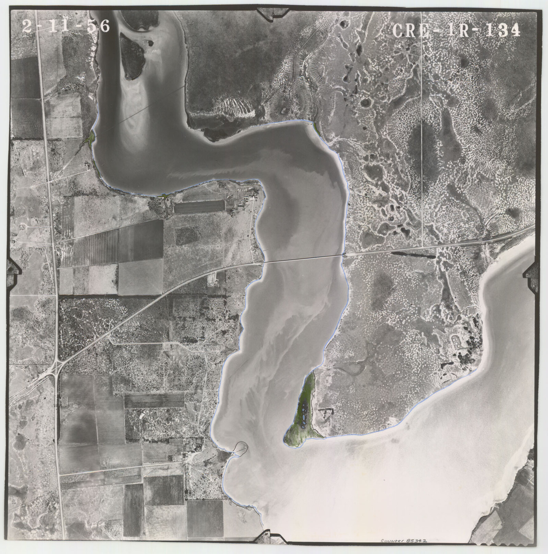
Flight Mission No. CRE-1R, Frame 134, Jackson County
CRE-1R-134
-
Map/Doc
85342
-
Collection
General Map Collection
-
Object Dates
1956/2/11 (Creation Date)
-
People and Organizations
U. S. Department of Agriculture (Publisher)
-
Counties
Jackson
-
Subjects
Aerial Photograph
-
Height x Width
16.2 x 16.0 inches
41.1 x 40.6 cm
-
Comments
Flown by Jack Ammann Photogrammetric Engineers of San Antonio, Texas.
Part of: General Map Collection
Baylor County Sketch File 22

Print $10.00
- Digital $50.00
Baylor County Sketch File 22
1913
Size 11.2 x 8.8 inches
Map/Doc 14199
Clay County Boundary File 5

Print $6.00
- Digital $50.00
Clay County Boundary File 5
Size 11.1 x 8.5 inches
Map/Doc 51373
United States - Gulf Coast - From Latitude 26° 33' to the Rio Grande Texas

Print $20.00
- Digital $50.00
United States - Gulf Coast - From Latitude 26° 33' to the Rio Grande Texas
1919
Size 27.2 x 18.4 inches
Map/Doc 72856
Hays County Sketch File 2

Print $4.00
- Digital $50.00
Hays County Sketch File 2
1846
Size 6.3 x 8.1 inches
Map/Doc 26200
Brewster County Rolled Sketch 11A

Print $20.00
- Digital $50.00
Brewster County Rolled Sketch 11A
1881
Size 24.9 x 23.0 inches
Map/Doc 5192
Kimble County Working Sketch 77

Print $20.00
- Digital $50.00
Kimble County Working Sketch 77
1970
Size 25.0 x 36.2 inches
Map/Doc 70145
Coke County Sketch File 1

Print $8.00
- Digital $50.00
Coke County Sketch File 1
1858
Size 8.3 x 7.7 inches
Map/Doc 18562
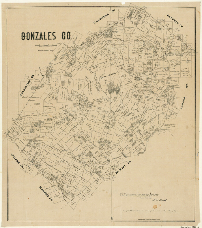
Gonzales County
Print $20.00
- Digital $50.00
Gonzales County
1880
Size 25.3 x 22.6 inches
Map/Doc 3594
Cottle County Sketch File E

Print $52.00
- Digital $50.00
Cottle County Sketch File E
1901
Size 11.4 x 9.1 inches
Map/Doc 19436
Roberts County Working Sketch 28

Print $20.00
- Digital $50.00
Roberts County Working Sketch 28
1983
Size 39.7 x 29.8 inches
Map/Doc 63554
The Cotton Kingdom: a Traveller's Observations on Cotton and Slavery in the American Slave States

The Cotton Kingdom: a Traveller's Observations on Cotton and Slavery in the American Slave States
Map/Doc 96571
Live Oak County

Print $40.00
- Digital $50.00
Live Oak County
1899
Size 52.1 x 37.5 inches
Map/Doc 78423
You may also like
Map of Goliad County Texas

Print $20.00
- Digital $50.00
Map of Goliad County Texas
1879
Size 19.5 x 21.8 inches
Map/Doc 4548
Located Line of the Panhandle & Gulf Ry. through State Lands, Public School and University, in Reagan County, Texas, Right of Way 200 feet wide

Print $40.00
- Digital $50.00
Located Line of the Panhandle & Gulf Ry. through State Lands, Public School and University, in Reagan County, Texas, Right of Way 200 feet wide
1904
Size 13.4 x 90.8 inches
Map/Doc 64063
Ward County Rolled Sketch 20

Print $20.00
- Digital $50.00
Ward County Rolled Sketch 20
1950
Size 27.4 x 22.7 inches
Map/Doc 8162
Blanco County Sketch File 21b

Print $40.00
- Digital $50.00
Blanco County Sketch File 21b
1882
Size 16.9 x 17.8 inches
Map/Doc 10930
Hamilton County Sketch File 5

Print $4.00
- Digital $50.00
Hamilton County Sketch File 5
Size 10.2 x 8.1 inches
Map/Doc 24908
Flight Mission No. CGI-3N, Frame 121, Cameron County

Print $20.00
- Digital $50.00
Flight Mission No. CGI-3N, Frame 121, Cameron County
1954
Size 18.5 x 22.3 inches
Map/Doc 84594
[Sketch showing west part of county]
![91712, [Sketch showing west part of county], Twichell Survey Records](https://historictexasmaps.com/wmedia_w700/maps/91712-1.tif.jpg)
Print $3.00
- Digital $50.00
[Sketch showing west part of county]
1907
Size 16.4 x 11.1 inches
Map/Doc 91712
Cooke County Sketch File 12

Print $4.00
- Digital $50.00
Cooke County Sketch File 12
Size 10.1 x 8.3 inches
Map/Doc 19246
El Paso County Rolled Sketch Z53

Print $40.00
- Digital $50.00
El Paso County Rolled Sketch Z53
1915
Size 36.6 x 51.7 inches
Map/Doc 8869
Orange County Working Sketch 25

Print $20.00
- Digital $50.00
Orange County Working Sketch 25
1949
Size 30.7 x 32.6 inches
Map/Doc 71357
Jno. B. Slaughter US Ranch situated in Garza County, Texas

Print $40.00
- Digital $50.00
Jno. B. Slaughter US Ranch situated in Garza County, Texas
Size 34.6 x 49.2 inches
Map/Doc 89946
Crockett County

Print $40.00
- Digital $50.00
Crockett County
1882
Size 57.6 x 31.6 inches
Map/Doc 88865