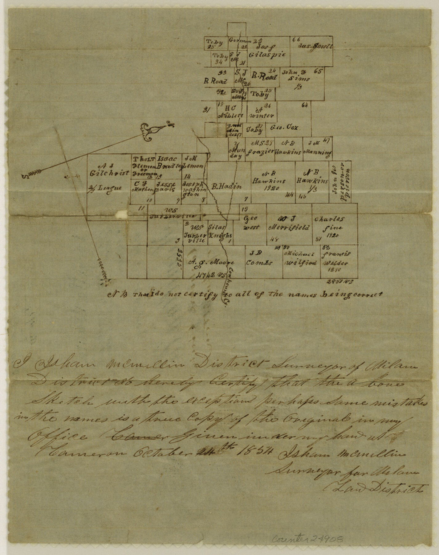
Hamilton County Sketch File 5
[Sketch on the head of Cowhouse Creek]
-
Map/Doc
24908
-
Collection
General Map Collection
-
Object Dates
1854/11/6 (File Date)
-
People and Organizations
Isham McMillin (Surveyor/Engineer)
-
Counties
Hamilton
-
Subjects
Surveying Sketch File
-
Height x Width
10.2 x 8.1 inches
25.9 x 20.6 cm
-
Medium
paper, manuscript
-
Features
Cowhouse Creek
Part of: General Map Collection
Cameron County Rolled Sketch 34

Print $20.00
- Digital $50.00
Cameron County Rolled Sketch 34
2000
Size 24.2 x 35.2 inches
Map/Doc 5397
Brewster County Working Sketch 82

Print $20.00
- Digital $50.00
Brewster County Working Sketch 82
1973
Size 45.3 x 36.6 inches
Map/Doc 67682
Glasscock County Sketch File 10

Print $6.00
- Digital $50.00
Glasscock County Sketch File 10
1935
Size 11.6 x 12.8 inches
Map/Doc 24172
Gulf Intracoastal Waterway, Tex. - Aransas Bay to Corpus Christi Bay - Modified Route of Main Channel/Dredging

Print $20.00
- Digital $50.00
Gulf Intracoastal Waterway, Tex. - Aransas Bay to Corpus Christi Bay - Modified Route of Main Channel/Dredging
1958
Size 31.2 x 42.5 inches
Map/Doc 61897
Red River County Sketch File 8

Print $22.00
- Digital $50.00
Red River County Sketch File 8
Size 14.7 x 16.8 inches
Map/Doc 35112
Jack County Sketch File 31

Print $40.00
- Digital $50.00
Jack County Sketch File 31
1926
Size 8.8 x 7.2 inches
Map/Doc 27565
Harris County Sketch File AA-1

Print $20.00
- Digital $50.00
Harris County Sketch File AA-1
Size 19.0 x 26.1 inches
Map/Doc 11646
Travis County Working Sketch 56

Print $20.00
- Digital $50.00
Travis County Working Sketch 56
1989
Size 19.7 x 20.4 inches
Map/Doc 69440
Harris County Sketch File 25

Print $8.00
- Digital $50.00
Harris County Sketch File 25
Size 9.0 x 11.8 inches
Map/Doc 25389
Flight Mission No. DAG-23K, Frame 171, Matagorda County

Print $20.00
- Digital $50.00
Flight Mission No. DAG-23K, Frame 171, Matagorda County
1953
Size 18.6 x 22.4 inches
Map/Doc 86509
Real County Rolled Sketch 3

Print $20.00
- Digital $50.00
Real County Rolled Sketch 3
1955
Size 14.6 x 23.3 inches
Map/Doc 7453
Cameron County Rolled Sketch 16

Print $20.00
- Digital $50.00
Cameron County Rolled Sketch 16
Size 31.8 x 37.4 inches
Map/Doc 8569
You may also like
Cameron County Sketch File 4

Print $52.00
- Digital $50.00
Cameron County Sketch File 4
1968
Size 11.3 x 8.8 inches
Map/Doc 17024
Flight Mission No. CRE-1R, Frame 4, Jackson County

Print $20.00
- Digital $50.00
Flight Mission No. CRE-1R, Frame 4, Jackson County
1956
Size 18.5 x 22.3 inches
Map/Doc 85324
Polk County Rolled Sketch 32

Print $20.00
- Digital $50.00
Polk County Rolled Sketch 32
Size 21.6 x 15.8 inches
Map/Doc 7318
[T. & P. Blocks 32-36, Townships 3N, 4N and 5N]
![90630, [T. & P. Blocks 32-36, Townships 3N, 4N and 5N], Twichell Survey Records](https://historictexasmaps.com/wmedia_w700/maps/90630.tif.jpg)
Print $20.00
- Digital $50.00
[T. & P. Blocks 32-36, Townships 3N, 4N and 5N]
Size 35.5 x 24.6 inches
Map/Doc 90630
Goliad County Working Sketch 17

Print $20.00
- Digital $50.00
Goliad County Working Sketch 17
1949
Size 21.8 x 22.2 inches
Map/Doc 63207
Archer County Sketch File 21

Print $40.00
- Digital $50.00
Archer County Sketch File 21
Size 30.3 x 19.8 inches
Map/Doc 10830
Preliminary Chart of Galveston Bay, Texas

Print $20.00
- Digital $50.00
Preliminary Chart of Galveston Bay, Texas
1855
Size 22.5 x 18.4 inches
Map/Doc 69867
Andrews County Sketch File 14

Print $48.00
- Digital $50.00
Andrews County Sketch File 14
1887
Size 8.0 x 8.4 inches
Map/Doc 12872
Duval County Rolled Sketch 5

Print $20.00
- Digital $50.00
Duval County Rolled Sketch 5
1929
Size 23.0 x 16.8 inches
Map/Doc 5732
Comanche County Working Sketch 14

Print $20.00
- Digital $50.00
Comanche County Working Sketch 14
1960
Size 17.9 x 23.9 inches
Map/Doc 68148
A Geographically Correct County Map of States Traversed by the St. Louis, Iron Mountain & Southern Railway and its Connections

Print $20.00
- Digital $50.00
A Geographically Correct County Map of States Traversed by the St. Louis, Iron Mountain & Southern Railway and its Connections
1877
Size 18.5 x 16.1 inches
Map/Doc 95782
Flight Mission No. DQN-2K, Frame 135, Calhoun County

Print $20.00
- Digital $50.00
Flight Mission No. DQN-2K, Frame 135, Calhoun County
1953
Size 19.0 x 22.5 inches
Map/Doc 84304