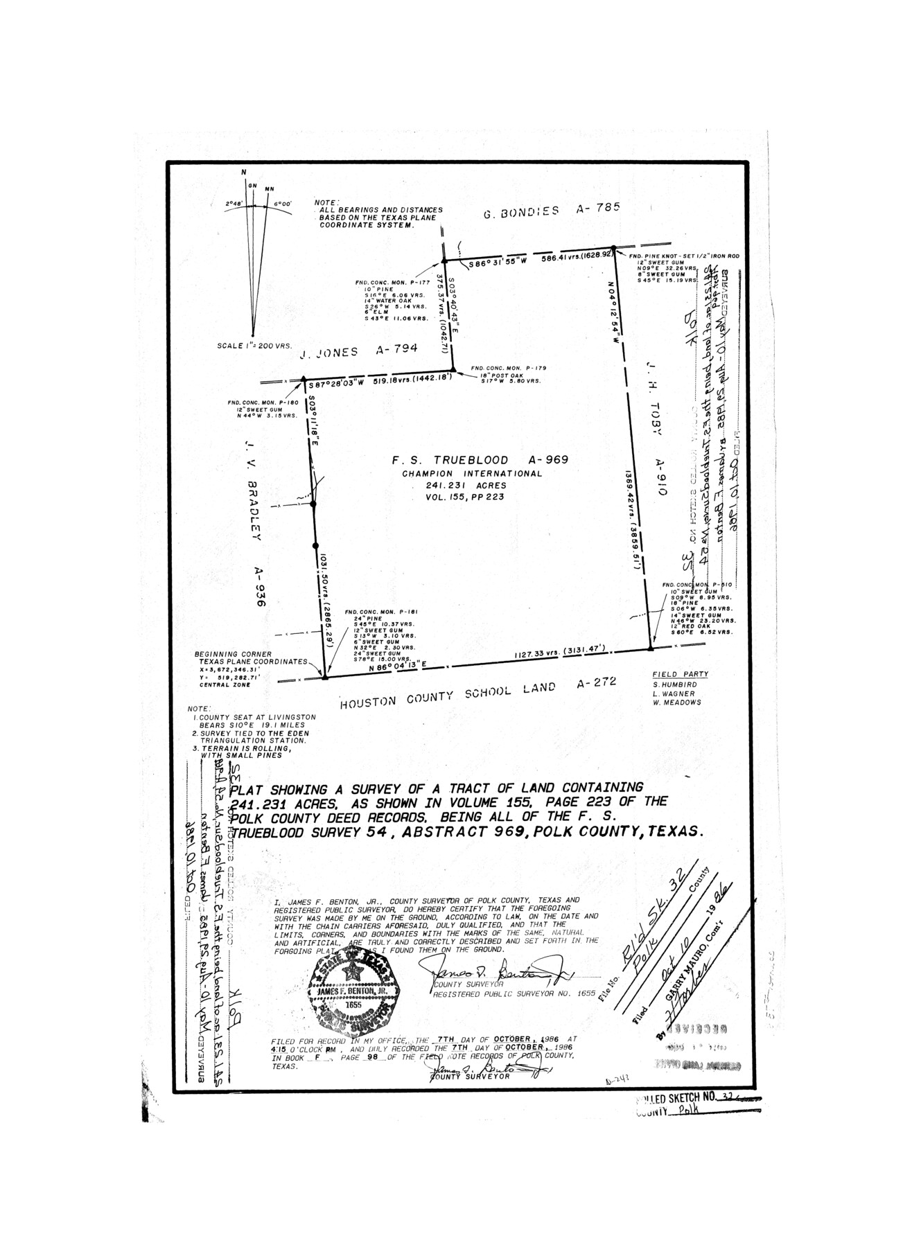
Polk County Rolled Sketch 32
Plat showing a survey of a tract of land containing 241.231 acres
-
Map/Doc
7318
-
Collection
General Map Collection
-
Object Dates
1985/8/29 (Survey Date)
1986/10/10 (File Date)
-
People and Organizations
James F. Benton, Jr. (Surveyor/Engineer)
-
Counties
Polk
-
Subjects
Surveying Rolled Sketch
-
Height x Width
21.6 x 15.8 inches
54.9 x 40.1 cm
-
Medium
mylar, print
-
Scale
1" = 200 varas
Part of: General Map Collection
McCulloch County Working Sketch 13

Print $20.00
- Digital $50.00
McCulloch County Working Sketch 13
1989
Size 36.7 x 33.3 inches
Map/Doc 70688
Blanco County Working Sketch 23

Print $40.00
- Digital $50.00
Blanco County Working Sketch 23
1962
Size 52.4 x 38.5 inches
Map/Doc 67383
Kendall County Working Sketch 9

Print $40.00
- Digital $50.00
Kendall County Working Sketch 9
1953
Size 52.8 x 37.2 inches
Map/Doc 66681
Flight Mission No. CUG-1P, Frame 74, Kleberg County

Print $20.00
- Digital $50.00
Flight Mission No. CUG-1P, Frame 74, Kleberg County
1956
Size 18.5 x 22.3 inches
Map/Doc 86139
Hutchinson County Sketch File 1

Print $22.00
- Digital $50.00
Hutchinson County Sketch File 1
Size 8.9 x 7.8 inches
Map/Doc 27172
Atascosa County Sketch File 2

Print $8.00
- Digital $50.00
Atascosa County Sketch File 2
1847
Size 7.8 x 5.9 inches
Map/Doc 13724
Dallas County Sketch File 19 1/2

Print $4.00
- Digital $50.00
Dallas County Sketch File 19 1/2
Size 9.9 x 8.2 inches
Map/Doc 20439
Henderson County Working Sketch 3

Print $20.00
- Digital $50.00
Henderson County Working Sketch 3
Size 28.5 x 38.3 inches
Map/Doc 66136
Hardin County Sketch File 63

Print $10.00
- Digital $50.00
Hardin County Sketch File 63
Size 11.3 x 8.8 inches
Map/Doc 25238
Flight Mission No. CRC-3R, Frame 36, Chambers County

Print $20.00
- Digital $50.00
Flight Mission No. CRC-3R, Frame 36, Chambers County
1956
Size 18.7 x 22.3 inches
Map/Doc 84809
Morris County Working Sketch 5

Print $20.00
- Digital $50.00
Morris County Working Sketch 5
1965
Size 24.7 x 18.9 inches
Map/Doc 71204
Flight Mission No. CGI-4N, Frame 158, Cameron County

Print $20.00
- Digital $50.00
Flight Mission No. CGI-4N, Frame 158, Cameron County
1955
Size 18.5 x 22.2 inches
Map/Doc 84666
You may also like
Roberts County Working Sketch 33

Print $20.00
- Digital $50.00
Roberts County Working Sketch 33
1978
Size 26.6 x 22.4 inches
Map/Doc 63559
Dimmit County Rolled Sketch 5

Print $20.00
- Digital $50.00
Dimmit County Rolled Sketch 5
1904
Size 42.7 x 18.2 inches
Map/Doc 5715
Trinity County Boundary File 102a

Print $50.00
- Digital $50.00
Trinity County Boundary File 102a
Size 9.6 x 4.7 inches
Map/Doc 59487
Webb County Sketch File 13b

Print $3.00
- Digital $50.00
Webb County Sketch File 13b
1893
Size 14.0 x 9.8 inches
Map/Doc 39803
Gillespie County

Print $40.00
- Digital $50.00
Gillespie County
1887
Size 38.9 x 49.8 inches
Map/Doc 4956
[Section 11, Block JS, Section 14, Block A, Lubbock County]
![92711, [Section 11, Block JS, Section 14, Block A, Lubbock County], Twichell Survey Records](https://historictexasmaps.com/wmedia_w700/maps/92711-1.tif.jpg)
Print $2.00
- Digital $50.00
[Section 11, Block JS, Section 14, Block A, Lubbock County]
1947
Size 7.1 x 8.5 inches
Map/Doc 92711
Neches River, Box Creek Sheet Cross Section

Print $6.00
- Digital $50.00
Neches River, Box Creek Sheet Cross Section
1940
Size 37.0 x 18.8 inches
Map/Doc 65079
[Plat showing traverse line run from I. R. Rock at southeast corner survey 58 northerly to the I. R. Rock corner at the northeast 60]
![91598, [Plat showing traverse line run from I. R. Rock at southeast corner survey 58 northerly to the I. R. Rock corner at the northeast 60], Twichell Survey Records](https://historictexasmaps.com/wmedia_w700/maps/91598-1.tif.jpg)
Print $20.00
- Digital $50.00
[Plat showing traverse line run from I. R. Rock at southeast corner survey 58 northerly to the I. R. Rock corner at the northeast 60]
1935
Size 21.7 x 18.0 inches
Map/Doc 91598
Caldwell County Working Sketch Graphic Index

Print $20.00
- Digital $50.00
Caldwell County Working Sketch Graphic Index
1935
Size 36.7 x 41.3 inches
Map/Doc 76483
Johnson County Working Sketch 20

Print $20.00
- Digital $50.00
Johnson County Working Sketch 20
1991
Size 23.4 x 29.0 inches
Map/Doc 66633
Nueces County Rolled Sketch 43A

Print $20.00
- Digital $50.00
Nueces County Rolled Sketch 43A
Size 24.0 x 35.4 inches
Map/Doc 6884
