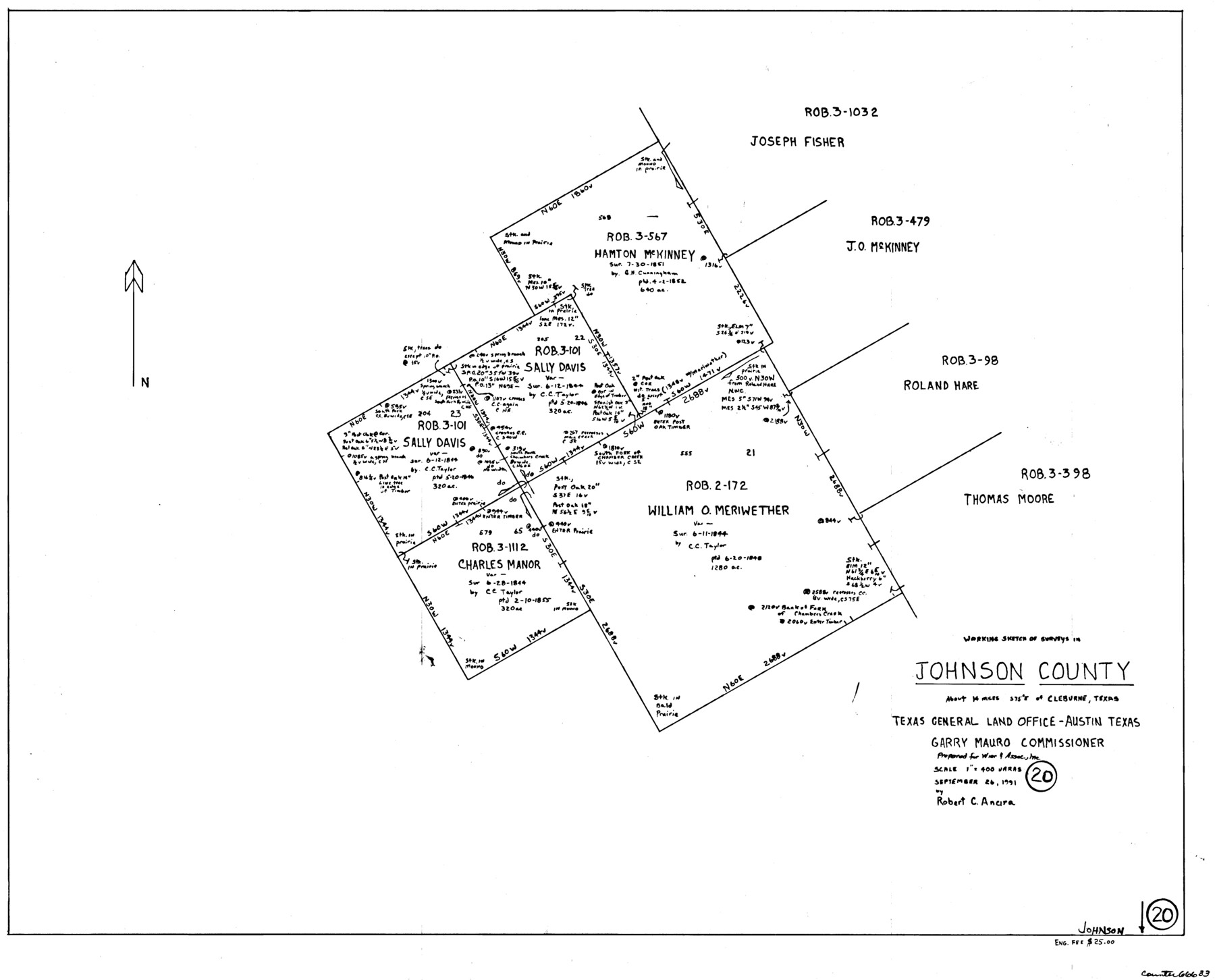
Johnson County Working Sketch 20
-
Map/Doc
66633
-
Collection
General Map Collection
-
Object Dates
9/26/1991 (Creation Date)
-
People and Organizations
Robert C. Ancira (Draftsman)
-
Counties
Johnson
-
Subjects
Surveying Working Sketch
-
Height x Width
23.4 x 29.0 inches
59.4 x 73.7 cm
-
Scale
1" = 400 varas
Part of: General Map Collection
Reeves County Working Sketch 24

Print $40.00
- Digital $50.00
Reeves County Working Sketch 24
1966
Size 38.7 x 76.5 inches
Map/Doc 63467

Improving Sabine Pass, Texas. Surveyed May 10th to June 30th, 1894 under the direction of Major James B. Quinn, Corps of Engineers, USA

Print $20.00
- Digital $50.00
Improving Sabine Pass, Texas. Surveyed May 10th to June 30th, 1894 under the direction of Major James B. Quinn, Corps of Engineers, USA
1894
Size 9.3 x 13.2 inches
Map/Doc 94155
Haskell County Rolled Sketch 3

Print $20.00
- Digital $50.00
Haskell County Rolled Sketch 3
1902
Size 18.1 x 21.0 inches
Map/Doc 6164
Mason County Sketch File 8

Print $4.00
- Digital $50.00
Mason County Sketch File 8
1876
Size 13.2 x 8.4 inches
Map/Doc 30691
San Augustine County Sketch File 14

Print $22.00
San Augustine County Sketch File 14
1888
Size 13.2 x 12.6 inches
Map/Doc 35662
Lipscomb County Boundary File 2

Print $6.00
- Digital $50.00
Lipscomb County Boundary File 2
Size 11.1 x 8.6 inches
Map/Doc 56315
Gulf Oil Corp. Fishgide - Freeport

Gulf Oil Corp. Fishgide - Freeport
1960
Size 12.3 x 22.4 inches
Map/Doc 75978
Bosque County Working Sketch 11

Print $20.00
- Digital $50.00
Bosque County Working Sketch 11
1952
Size 10.8 x 30.4 inches
Map/Doc 67444
Jeff Davis County

Print $40.00
- Digital $50.00
Jeff Davis County
1893
Size 26.2 x 48.2 inches
Map/Doc 3719
Webb County Working Sketch 26

Print $20.00
- Digital $50.00
Webb County Working Sketch 26
1931
Size 17.9 x 18.4 inches
Map/Doc 72391
Harris County Historic Topographic 32

Print $20.00
- Digital $50.00
Harris County Historic Topographic 32
1916
Size 29.3 x 21.6 inches
Map/Doc 65843
You may also like
Duval County Rolled Sketch 38

Print $20.00
- Digital $50.00
Duval County Rolled Sketch 38
1937
Size 22.6 x 16.1 inches
Map/Doc 5755
El Paso County Boundary File 5

Print $80.00
- Digital $50.00
El Paso County Boundary File 5
Size 34.7 x 48.4 inches
Map/Doc 53078
Map No. 1 - Rio Bravo del Norte section of boundary between the United States & Mexico agreed upon by the Joint Commission under the Treaty of Guadalupe Hidalgo

Print $20.00
- Digital $50.00
Map No. 1 - Rio Bravo del Norte section of boundary between the United States & Mexico agreed upon by the Joint Commission under the Treaty of Guadalupe Hidalgo
1852
Size 18.2 x 27.2 inches
Map/Doc 72865
Duval County Boundary File 3j

Print $12.00
- Digital $50.00
Duval County Boundary File 3j
Size 12.8 x 8.0 inches
Map/Doc 52753
Outer Continental Shelf Leasing Maps (Texas Offshore Operations)

Print $20.00
- Digital $50.00
Outer Continental Shelf Leasing Maps (Texas Offshore Operations)
Size 17.0 x 18.4 inches
Map/Doc 75847
San Patricio County NRC Article 33.136 Sketch 10

Print $692.00
San Patricio County NRC Article 33.136 Sketch 10
2023
Map/Doc 97294
Red River, Levee Improvement Districts Widths of Floodways - Bois D'Arc Creek

Print $20.00
- Digital $50.00
Red River, Levee Improvement Districts Widths of Floodways - Bois D'Arc Creek
1921
Size 29.5 x 26.0 inches
Map/Doc 65271
[Beaumont, Sour Lake and Western Ry. Right of Way and Alignment - Frisco]
![64121, [Beaumont, Sour Lake and Western Ry. Right of Way and Alignment - Frisco], General Map Collection](https://historictexasmaps.com/wmedia_w700/maps/64121.tif.jpg)
Print $20.00
- Digital $50.00
[Beaumont, Sour Lake and Western Ry. Right of Way and Alignment - Frisco]
1910
Size 20.0 x 45.8 inches
Map/Doc 64121
Chambers County Sketch File 34

Print $10.00
- Digital $50.00
Chambers County Sketch File 34
1951
Size 14.3 x 8.8 inches
Map/Doc 17620
Intracoastal Waterway in Texas - Corpus Christi to Point Isabel including Arroyo Colorado to Mo. Pac. R.R. Bridge Near Harlingen

Print $20.00
- Digital $50.00
Intracoastal Waterway in Texas - Corpus Christi to Point Isabel including Arroyo Colorado to Mo. Pac. R.R. Bridge Near Harlingen
1934
Size 21.6 x 32.7 inches
Map/Doc 61879
Flight Mission No. DIX-10P, Frame 167, Aransas County

Print $20.00
- Digital $50.00
Flight Mission No. DIX-10P, Frame 167, Aransas County
1956
Size 18.6 x 22.3 inches
Map/Doc 83957
Flight Mission No. BRA-8M, Frame 87, Jefferson County

Print $20.00
- Digital $50.00
Flight Mission No. BRA-8M, Frame 87, Jefferson County
1953
Size 18.6 x 22.3 inches
Map/Doc 85607