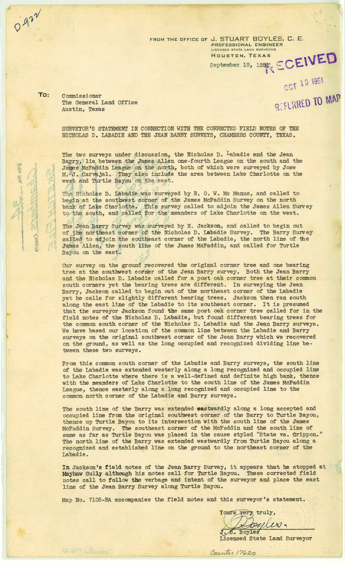
Chambers County Sketch File 34
Surveyor's statement in connection with the corrected field notes of the Nicholas D. Labadie and the Jean Barry surveys, Chambers County, Texas
-
Map/Doc
17620
-
Collection
General Map Collection
-
Object Dates
1951/10/19 (File Date)
1951/9/19 (Creation Date)
-
People and Organizations
J.S. Boyles (Surveyor/Engineer)
-
Counties
Chambers
-
Subjects
Surveying Sketch File
-
Height x Width
14.3 x 8.8 inches
36.3 x 22.4 cm
-
Medium
multi-page, multi-format
-
Features
Lake Charlotte
Turtle Bayou
Part of: General Map Collection
Zapata County Working Sketch 5

Print $20.00
- Digital $50.00
Zapata County Working Sketch 5
1940
Size 23.4 x 18.3 inches
Map/Doc 62056
Old Miscellaneous File 39

Print $10.00
- Digital $50.00
Old Miscellaneous File 39
1893
Size 14.2 x 8.8 inches
Map/Doc 75284
Hockley County Sketch File 19

Print $20.00
- Digital $50.00
Hockley County Sketch File 19
1944
Size 14.9 x 25.8 inches
Map/Doc 11775
Map of Nacogdoches County

Print $40.00
- Digital $50.00
Map of Nacogdoches County
1846
Size 83.7 x 76.1 inches
Map/Doc 82243
Flight Mission No. DIX-6P, Frame 112, Aransas County

Print $20.00
- Digital $50.00
Flight Mission No. DIX-6P, Frame 112, Aransas County
1956
Size 18.9 x 22.7 inches
Map/Doc 83818
Flight Mission No. BRA-16M, Frame 58, Jefferson County

Print $20.00
- Digital $50.00
Flight Mission No. BRA-16M, Frame 58, Jefferson County
1953
Size 18.4 x 22.5 inches
Map/Doc 85675
Padre Island National Seashore, Texas - Dependent Resurvey

Print $4.00
- Digital $50.00
Padre Island National Seashore, Texas - Dependent Resurvey
2001
Size 18.2 x 24.3 inches
Map/Doc 60548
Terrell County Working Sketch 6

Print $20.00
- Digital $50.00
Terrell County Working Sketch 6
1914
Size 15.7 x 21.9 inches
Map/Doc 62155
Maps of Gulf Intracoastal Waterway, Texas - Sabine River to the Rio Grande and connecting waterways including ship channels

Print $20.00
- Digital $50.00
Maps of Gulf Intracoastal Waterway, Texas - Sabine River to the Rio Grande and connecting waterways including ship channels
1966
Size 14.6 x 22.3 inches
Map/Doc 61934
Brewster County Working Sketch 13

Print $20.00
- Digital $50.00
Brewster County Working Sketch 13
1928
Size 39.5 x 43.9 inches
Map/Doc 67546
The Great Texas Coastal Birding Trail, Central Texas Coast

The Great Texas Coastal Birding Trail, Central Texas Coast
Size 33.1 x 36.0 inches
Map/Doc 94339
Bosque County Working Sketch 2

Print $20.00
- Digital $50.00
Bosque County Working Sketch 2
Size 19.7 x 19.6 inches
Map/Doc 67435
You may also like
Intracoastal Waterway in Texas - Corpus Christi to Point Isabel including Arroyo Colorado to Mo. Pac. R.R. Bridge Near Harlingen

Print $20.00
- Digital $50.00
Intracoastal Waterway in Texas - Corpus Christi to Point Isabel including Arroyo Colorado to Mo. Pac. R.R. Bridge Near Harlingen
1933
Size 28.1 x 41.2 inches
Map/Doc 61845
Andrews County

Print $40.00
- Digital $50.00
Andrews County
1925
Size 42.6 x 57.1 inches
Map/Doc 66703
Map of Cherokee County

Print $20.00
- Digital $50.00
Map of Cherokee County
1879
Size 28.5 x 21.4 inches
Map/Doc 4517
Colorado River, Wharton to Bay City Sheet 1, Texas

Print $40.00
- Digital $50.00
Colorado River, Wharton to Bay City Sheet 1, Texas
1924
Size 73.9 x 38.9 inches
Map/Doc 65262
[Surveys in McMullen and McGloin's Colony along the San Antonio River]
![30, [Surveys in McMullen and McGloin's Colony along the San Antonio River], General Map Collection](https://historictexasmaps.com/wmedia_w700/maps/30-1.tif.jpg)
Print $20.00
- Digital $50.00
[Surveys in McMullen and McGloin's Colony along the San Antonio River]
1828
Size 19.3 x 24.5 inches
Map/Doc 30
Gray County Working Sketch 8

Print $20.00
- Digital $50.00
Gray County Working Sketch 8
1983
Size 18.3 x 22.8 inches
Map/Doc 63239
Anderson County Working Sketch 42

Print $40.00
- Digital $50.00
Anderson County Working Sketch 42
1987
Size 34.4 x 51.1 inches
Map/Doc 67042
Pecos County Working Sketch 83
Print $20.00
- Digital $50.00
Pecos County Working Sketch 83
1961
Size 18.7 x 28.7 inches
Map/Doc 71555
Young County Rolled Sketch 19

Print $20.00
- Digital $50.00
Young County Rolled Sketch 19
2021
Size 24.3 x 30.4 inches
Map/Doc 97023
Glasscock County Sketch File 27

Print $10.00
- Digital $50.00
Glasscock County Sketch File 27
1989
Size 11.3 x 8.8 inches
Map/Doc 24206
Upton County Working Sketch 12

Print $40.00
- Digital $50.00
Upton County Working Sketch 12
1937
Size 43.6 x 77.9 inches
Map/Doc 69508
Live Oak County Working Sketch 37

Print $40.00
- Digital $50.00
Live Oak County Working Sketch 37
2012
Size 34.4 x 48.7 inches
Map/Doc 93363