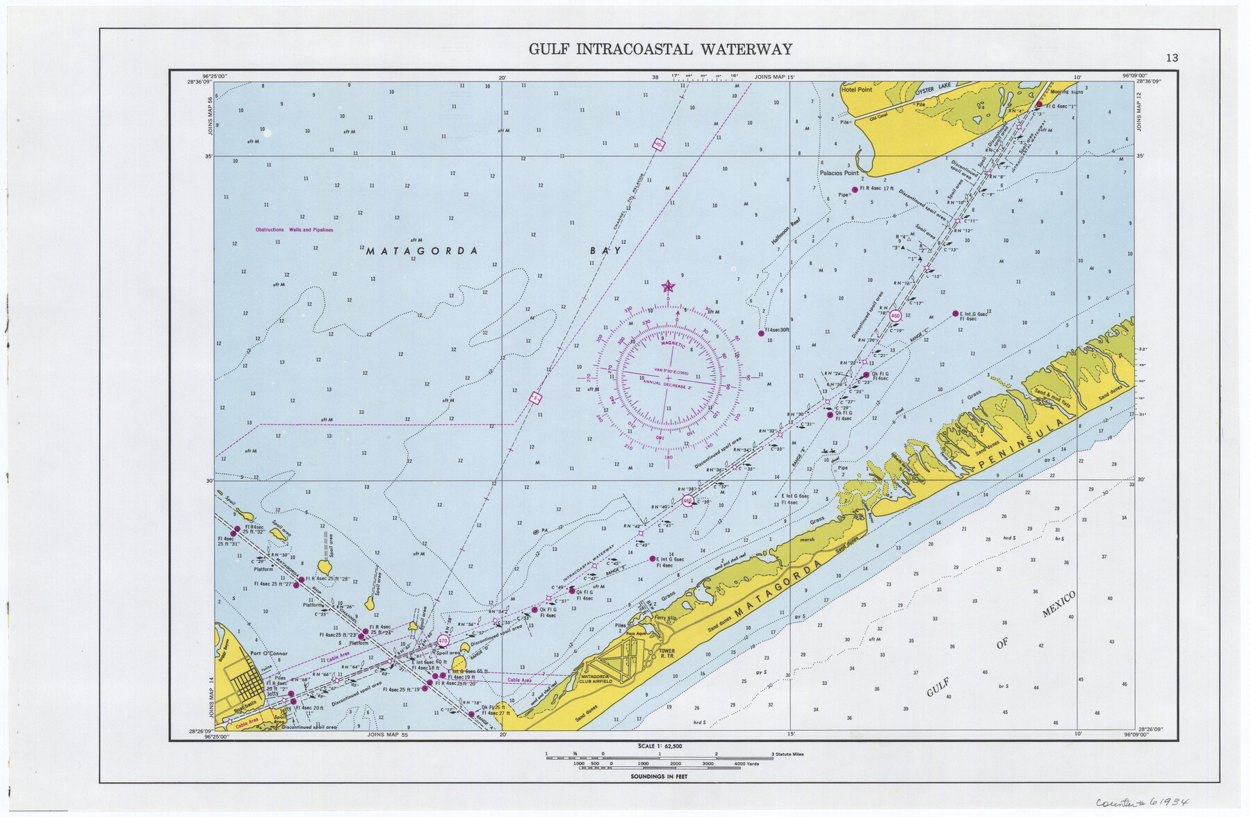
Maps of Gulf Intracoastal Waterway, Texas - Sabine River to the Rio Grande and connecting waterways including ship channels
-
Map/Doc
61934
-
Collection
General Map Collection
-
Object Dates
1966 (Creation Date)
-
Subjects
Intracoastal Waterways
-
Height x Width
14.6 x 22.3 inches
37.1 x 56.6 cm
Part of: General Map Collection
Panola County Working Sketch 13

Print $40.00
- Digital $50.00
Panola County Working Sketch 13
1945
Map/Doc 71422
DeWitt County Working Sketch 10

Print $20.00
- Digital $50.00
DeWitt County Working Sketch 10
1980
Size 15.1 x 12.0 inches
Map/Doc 68600
Panola County Working Sketch 8

Print $20.00
- Digital $50.00
Panola County Working Sketch 8
1943
Map/Doc 71417
Hill County Working Sketch 4

Print $20.00
- Digital $50.00
Hill County Working Sketch 4
1982
Size 25.3 x 23.3 inches
Map/Doc 66190
Live Oak County Rolled Sketch 10A

Print $20.00
- Digital $50.00
Live Oak County Rolled Sketch 10A
1983
Size 38.4 x 43.6 inches
Map/Doc 9457
Nueces County Sketch File 41

Print $8.00
- Digital $50.00
Nueces County Sketch File 41
Size 11.1 x 8.6 inches
Map/Doc 32629
Cherokee County Working Sketch 18

Print $40.00
- Digital $50.00
Cherokee County Working Sketch 18
1958
Size 74.6 x 43.6 inches
Map/Doc 67973
Dimmit County Sketch File 28

Print $40.00
- Digital $50.00
Dimmit County Sketch File 28
Size 14.7 x 17.4 inches
Map/Doc 11350
[Surveys in the Bexar District along the Cibolo Creek]
![3168, [Surveys in the Bexar District along the Cibolo Creek], General Map Collection](https://historictexasmaps.com/wmedia_w700/maps/3168.tif.jpg)
Print $2.00
- Digital $50.00
[Surveys in the Bexar District along the Cibolo Creek]
1846
Size 5.1 x 6.7 inches
Map/Doc 3168
Runnels County Rolled Sketch C

Print $20.00
- Digital $50.00
Runnels County Rolled Sketch C
1892
Size 16.0 x 21.0 inches
Map/Doc 7541
Edwards County Working Sketch 123

Print $20.00
- Digital $50.00
Edwards County Working Sketch 123
1976
Size 18.3 x 25.2 inches
Map/Doc 68999
Montgomery County Sketch File 6

Print $4.00
- Digital $50.00
Montgomery County Sketch File 6
Size 4.6 x 5.7 inches
Map/Doc 31781
You may also like
Rueben M. Ellerd 17,870 acres of land in Bailey and Cochran Cos., Texas

Print $20.00
- Digital $50.00
Rueben M. Ellerd 17,870 acres of land in Bailey and Cochran Cos., Texas
1906
Size 22.4 x 30.0 inches
Map/Doc 90242
Parker County Sketch File 9a

Print $4.00
- Digital $50.00
Parker County Sketch File 9a
1859
Size 9.0 x 7.7 inches
Map/Doc 33540

Webb County Rolled Sketch 78A

Print $20.00
- Digital $50.00
Webb County Rolled Sketch 78A
Size 28.4 x 23.0 inches
Map/Doc 90053
Flight Mission No. DIX-10P, Frame 144, Aransas County

Print $20.00
- Digital $50.00
Flight Mission No. DIX-10P, Frame 144, Aransas County
1956
Size 18.6 x 22.3 inches
Map/Doc 83946
Edwards County Working Sketch 34

Print $20.00
- Digital $50.00
Edwards County Working Sketch 34
1948
Size 39.2 x 23.3 inches
Map/Doc 68910
Railroad Track Map, H&TCRRCo., Falls County, Texas

Print $4.00
- Digital $50.00
Railroad Track Map, H&TCRRCo., Falls County, Texas
1918
Size 11.6 x 18.6 inches
Map/Doc 62848
A Map of the United States including every county enumerated in the last census & since formed with the population of the several states, railroads, canals, & c.

A Map of the United States including every county enumerated in the last census & since formed with the population of the several states, railroads, canals, & c.
Size 46.0 x 61.0 inches
Map/Doc 95918
Jefferson County Rolled Sketch 48

Print $20.00
- Digital $50.00
Jefferson County Rolled Sketch 48
1963
Size 28.3 x 34.8 inches
Map/Doc 6403
Hutchinson County Sketch File 39

Print $20.00
- Digital $50.00
Hutchinson County Sketch File 39
1938
Size 23.5 x 19.0 inches
Map/Doc 11822
Map showing connection of land-lines with M. & P. E. Ry. through Uvalde Co.

Print $40.00
- Digital $50.00
Map showing connection of land-lines with M. & P. E. Ry. through Uvalde Co.
1882
Size 11.8 x 86.3 inches
Map/Doc 64179
Galveston County NRC Article 33.136 Sketch 31

Print $22.00
- Digital $50.00
Galveston County NRC Article 33.136 Sketch 31
2005
Size 22.2 x 33.7 inches
Map/Doc 83280