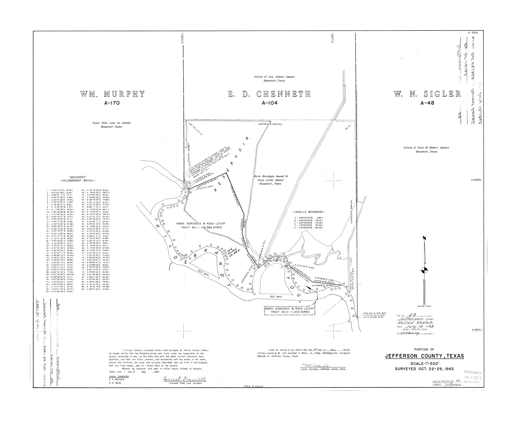
Jefferson County Rolled Sketch 48
Portion of Jefferson County, Texas
-
Map/Doc
6403
-
Collection
General Map Collection
-
Object Dates
1963/5/1 (Creation Date)
1962/10/29 (Survey Date)
1963/7/12 (File Date)
-
People and Organizations
E.E. Whitfield (Chainman/Field Personnel)
A.H. Smith (Chainman/Field Personnel)
Forrest Daniell (Surveyor/Engineer)
-
Counties
Jefferson
-
Subjects
Surveying Rolled Sketch
-
Height x Width
28.3 x 34.8 inches
71.9 x 88.4 cm
-
Scale
1" = 500 feet
Part of: General Map Collection
San Augustine County Working Sketch 23

Print $20.00
- Digital $50.00
San Augustine County Working Sketch 23
1974
Size 23.6 x 36.4 inches
Map/Doc 63711
Chambers County Sketch File 36

Print $11.00
- Digital $50.00
Chambers County Sketch File 36
1935
Size 15.6 x 9.1 inches
Map/Doc 17647
Rusk County Working Sketch 5

Print $20.00
- Digital $50.00
Rusk County Working Sketch 5
1983
Size 33.1 x 25.7 inches
Map/Doc 63640
Menard County Working Sketch 12

Print $20.00
- Digital $50.00
Menard County Working Sketch 12
1939
Size 24.7 x 30.0 inches
Map/Doc 70959
Hudspeth County Sketch File 7

Print $6.00
- Digital $50.00
Hudspeth County Sketch File 7
1900
Size 14.2 x 8.7 inches
Map/Doc 26892
Erath County Working Sketch 52

Print $20.00
- Digital $50.00
Erath County Working Sketch 52
1992
Size 33.9 x 33.6 inches
Map/Doc 69134
Eastland County Sketch File 7

Print $4.00
- Digital $50.00
Eastland County Sketch File 7
1872
Size 12.6 x 8.5 inches
Map/Doc 21574
Railroad Track Map, H&TCRRCo., Falls County, Texas

Print $4.00
- Digital $50.00
Railroad Track Map, H&TCRRCo., Falls County, Texas
1918
Size 11.7 x 18.5 inches
Map/Doc 62858
Map of Jack County

Print $40.00
- Digital $50.00
Map of Jack County
1895
Size 49.7 x 37.2 inches
Map/Doc 16858
[Right of Way & Track Map, The Texas & Pacific Ry. Co. Main Line]
![64666, [Right of Way & Track Map, The Texas & Pacific Ry. Co. Main Line], General Map Collection](https://historictexasmaps.com/wmedia_w700/maps/64666.tif.jpg)
Print $20.00
- Digital $50.00
[Right of Way & Track Map, The Texas & Pacific Ry. Co. Main Line]
Size 11.0 x 18.5 inches
Map/Doc 64666
Map of Texas and Pacific Ry. Company's Surveys in the 80 Mile Reserve

Print $40.00
- Digital $50.00
Map of Texas and Pacific Ry. Company's Surveys in the 80 Mile Reserve
1885
Size 44.0 x 51.6 inches
Map/Doc 83557
Leon County Sketch File 11

Print $4.00
- Digital $50.00
Leon County Sketch File 11
1858
Size 10.1 x 8.0 inches
Map/Doc 29761
You may also like
Hood County Working Sketch 15

Print $20.00
- Digital $50.00
Hood County Working Sketch 15
1985
Size 30.0 x 28.2 inches
Map/Doc 66209
Coleman County Working Sketch 5

Print $20.00
- Digital $50.00
Coleman County Working Sketch 5
1928
Size 27.0 x 25.6 inches
Map/Doc 68071
Upshur County Working Sketch 16

Print $20.00
- Digital $50.00
Upshur County Working Sketch 16
1997
Size 43.7 x 36.0 inches
Map/Doc 78229
Sketch J No. 2 Showing the Progress of the Survey of San Francisco Bay and Vicinity Section X From 1850 to 1852

Print $20.00
- Digital $50.00
Sketch J No. 2 Showing the Progress of the Survey of San Francisco Bay and Vicinity Section X From 1850 to 1852
1852
Size 12.3 x 12.7 inches
Map/Doc 97229
Lipscomb County Sketch File 6

Print $20.00
- Digital $50.00
Lipscomb County Sketch File 6
1965
Size 19.4 x 26.1 inches
Map/Doc 12005
Shelby County Working Sketch 2

Print $20.00
- Digital $50.00
Shelby County Working Sketch 2
Size 32.9 x 37.3 inches
Map/Doc 63855
Brewster County Rolled Sketch 101

Print $40.00
- Digital $50.00
Brewster County Rolled Sketch 101
1927
Size 74.4 x 42.4 inches
Map/Doc 9196
Map of Concho County
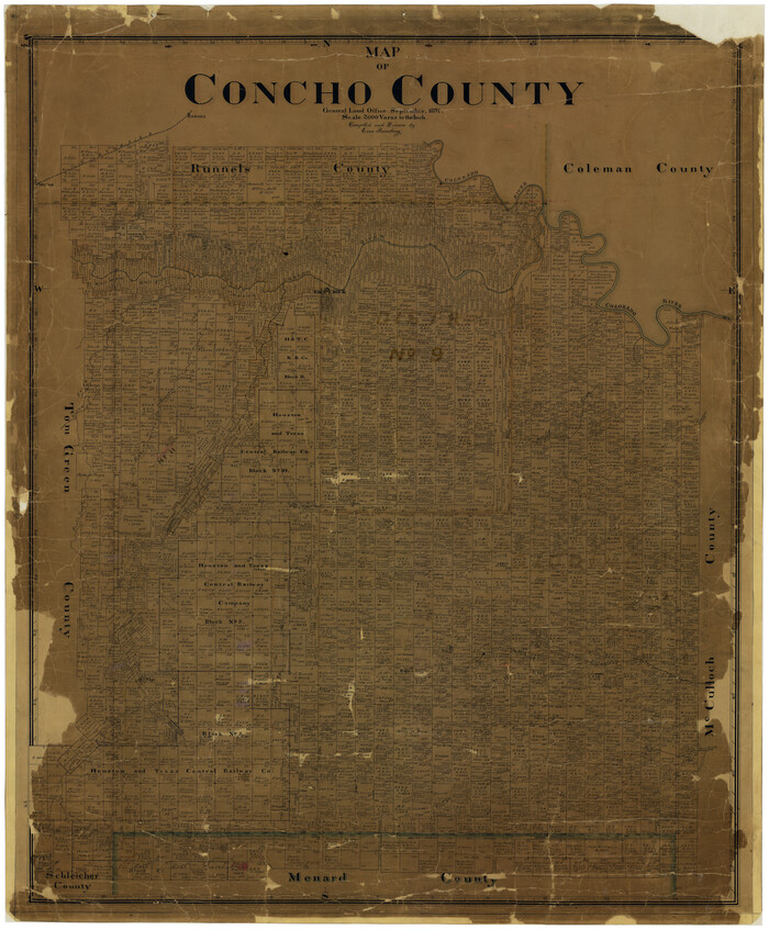
Print $20.00
- Digital $50.00
Map of Concho County
1897
Size 47.0 x 39.5 inches
Map/Doc 4733
Red River County Rolled Sketch 11

Print $40.00
- Digital $50.00
Red River County Rolled Sketch 11
2006
Size 36.8 x 48.6 inches
Map/Doc 88614
Hemphill County Working Sketch 12

Print $20.00
- Digital $50.00
Hemphill County Working Sketch 12
1967
Size 23.3 x 34.9 inches
Map/Doc 66107
McMullen County Working Sketch 37

Print $20.00
- Digital $50.00
McMullen County Working Sketch 37
1969
Size 37.4 x 38.4 inches
Map/Doc 70738
Frio County Sketch File 18

Print $8.00
- Digital $50.00
Frio County Sketch File 18
1961
Size 14.3 x 8.9 inches
Map/Doc 23155