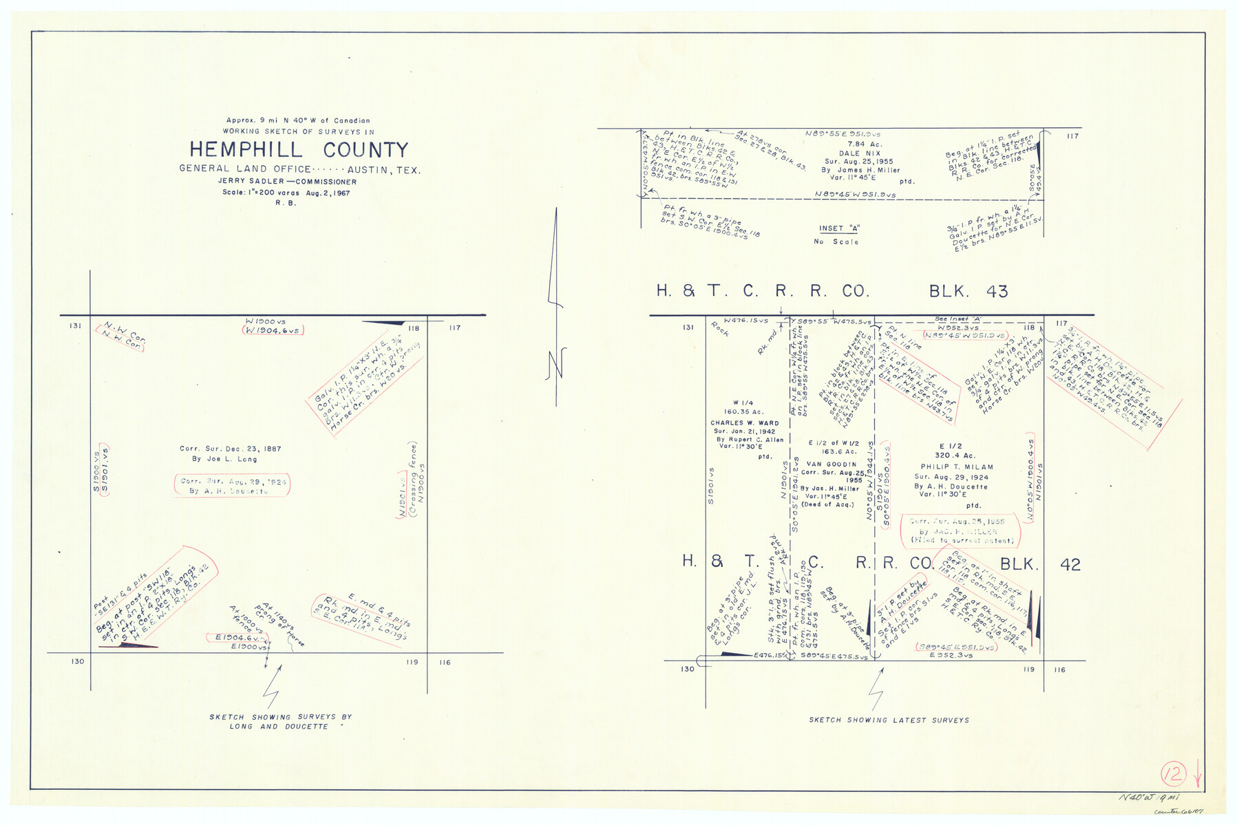
Hemphill County Working Sketch 12
-
Map/Doc
66107
-
Collection
General Map Collection
-
Object Dates
8/2/1967 (Creation Date)
-
People and Organizations
Roy Buckholts (Draftsman)
-
Counties
Hemphill
-
Subjects
Surveying Working Sketch
-
Height x Width
23.3 x 34.9 inches
59.2 x 88.7 cm
-
Scale
1" = 200 varas
Part of: General Map Collection
Map of Scurry County

Print $20.00
- Digital $50.00
Map of Scurry County
1899
Size 39.8 x 34.7 inches
Map/Doc 63029
Val Verde County Rolled Sketch 43

Print $20.00
- Digital $50.00
Val Verde County Rolled Sketch 43
1920
Size 20.4 x 22.6 inches
Map/Doc 8117
Kerr County Sketch File 1b

Print $2.00
- Digital $50.00
Kerr County Sketch File 1b
Size 8.1 x 10.2 inches
Map/Doc 28850
Hunt County Rolled Sketch 5

Print $20.00
- Digital $50.00
Hunt County Rolled Sketch 5
1966
Size 24.7 x 24.5 inches
Map/Doc 6275
Map of Panola County

Print $20.00
- Digital $50.00
Map of Panola County
1882
Size 20.9 x 22.0 inches
Map/Doc 4504
Schleicher County Rolled Sketch 19

Print $20.00
- Digital $50.00
Schleicher County Rolled Sketch 19
Size 25.0 x 21.9 inches
Map/Doc 7761
Brewster County Sketch File 55

Print $14.00
- Digital $50.00
Brewster County Sketch File 55
1999
Size 10.9 x 6.4 inches
Map/Doc 16385
Brazoria County Working Sketch 36

Print $40.00
- Digital $50.00
Brazoria County Working Sketch 36
1981
Size 43.4 x 71.4 inches
Map/Doc 67521
Eastland County Working Sketch 57

Print $20.00
- Digital $50.00
Eastland County Working Sketch 57
1985
Size 21.7 x 21.8 inches
Map/Doc 68838
Midland County Working Sketch 33

Print $20.00
- Digital $50.00
Midland County Working Sketch 33
1982
Size 38.2 x 36.2 inches
Map/Doc 71014
Cass County Working Sketch 52

Print $20.00
- Digital $50.00
Cass County Working Sketch 52
2001
Size 32.9 x 23.9 inches
Map/Doc 67955
Chambers County Sketch File 16

Print $4.00
- Digital $50.00
Chambers County Sketch File 16
Size 7.9 x 12.7 inches
Map/Doc 17566
You may also like
[Surveys along the Leon River and Plum Creek]
![69730, [Surveys along the Leon River and Plum Creek], General Map Collection](https://historictexasmaps.com/wmedia_w700/maps/69730.tif.jpg)
Print $2.00
- Digital $50.00
[Surveys along the Leon River and Plum Creek]
1846
Size 9.0 x 14.0 inches
Map/Doc 69730
Van Zandt County Working Sketch 14

Print $20.00
- Digital $50.00
Van Zandt County Working Sketch 14
1982
Size 13.2 x 11.5 inches
Map/Doc 72264
Cooke County Working Sketch 7

Print $20.00
- Digital $50.00
Cooke County Working Sketch 7
1939
Size 25.1 x 33.7 inches
Map/Doc 68244
Gregg County Sketch File 11

Print $12.00
- Digital $50.00
Gregg County Sketch File 11
1933
Size 14.4 x 8.9 inches
Map/Doc 24591
Anderson County Boundary File 10

Print $13.00
- Digital $50.00
Anderson County Boundary File 10
Size 16.0 x 10.2 inches
Map/Doc 49759
Potter County Working Sketch 11

Print $20.00
- Digital $50.00
Potter County Working Sketch 11
1972
Size 27.4 x 26.4 inches
Map/Doc 71671
Fort Bend County Rolled Sketch 30 1/2

Print $20.00
- Digital $50.00
Fort Bend County Rolled Sketch 30 1/2
Size 20.1 x 26.5 inches
Map/Doc 5902
Knox County Sketch File 20

Print $20.00
- Digital $50.00
Knox County Sketch File 20
1917
Size 26.2 x 17.6 inches
Map/Doc 11962
Gonzales County

Print $40.00
- Digital $50.00
Gonzales County
1920
Size 41.0 x 51.2 inches
Map/Doc 1841
Reeves County Rolled Sketch 26

Print $20.00
- Digital $50.00
Reeves County Rolled Sketch 26
1985
Size 21.6 x 27.7 inches
Map/Doc 7495
Haskell County Rolled Sketch 12
Print $40.00
- Digital $50.00
Haskell County Rolled Sketch 12
Size 56.7 x 36.1 inches
Map/Doc 9147
Palo Pinto County Working Sketch 8

Print $20.00
- Digital $50.00
Palo Pinto County Working Sketch 8
1922
Map/Doc 71391