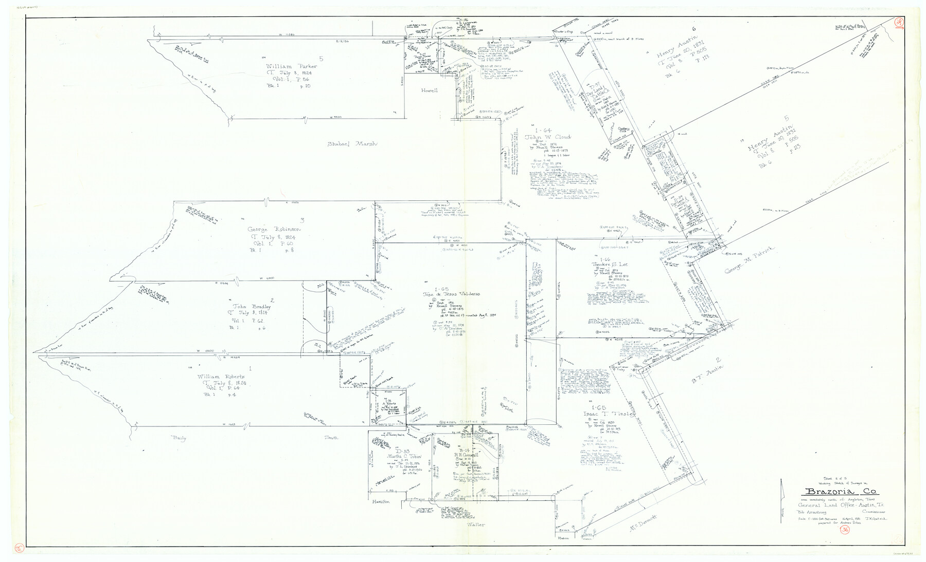
Brazoria County Working Sketch 36
- 
                          Map/Doc67521
- 
                            CollectionGeneral Map Collection
- 
                            Object Dates4/16/1981 (Creation Date)
- 
                            People and OrganizationsJoan Kilpatrick (Draftsman)Bob Armstrong (GLO Commissioner)
- 
                            CountiesBrazoria
- 
                            SubjectsSurveying Working Sketch
- 
                            Height x Width43.4 x 71.4 inches110.2 x 181.4 cm
- 
                            Scale1" = 360 varas
- 
                            CommentsSurveys located immediately North of Angleton, Texas.
Part of: General Map Collection
            Sabine Bank to East Bay including Heald Bank


                                            Print $20.00                    
                                             -                         Digital $50.00                                    
                Sabine Bank to East Bay including Heald Bank
1982
Size 44.8 x 34.3 inches
                                Map/Doc 69852
            
            Garza County Rolled Sketch 12


                                            Print $20.00                    
                                             -                         Digital $50.00                                    
                Garza County Rolled Sketch 12
1916
Size 31.5 x 26.0 inches
                                Map/Doc 6069
            
            Glasscock County


                                            Print $20.00                    
                                             -                         Digital $50.00                                    
                Glasscock County
1933
Size 41.1 x 34.7 inches
                                Map/Doc 77290
            
            Tom Green County Rolled Sketch 27


                                            Print $20.00                    
                                             -                         Digital $50.00                                    
                Tom Green County Rolled Sketch 27
Size 36.1 x 45.4 inches
                                Map/Doc 10008
            
            Guadalupe County Sketch File 15a


                                            Print $9.00                    
                                             -                         Digital $50.00                                    
                Guadalupe County Sketch File 15a
Size 10.3 x 8.2 inches
                                Map/Doc 24687
            
            Sterling County Rolled Sketch 13


                                            Print $20.00                    
                                             -                         Digital $50.00                                    
                Sterling County Rolled Sketch 13
1945
Size 34.9 x 27.3 inches
                                Map/Doc 7847
            
            Kleberg County Aerial Photograph Index Sheet 3


                                            Print $20.00                    
                                             -                         Digital $50.00                                    
                Kleberg County Aerial Photograph Index Sheet 3
1956
Size 19.1 x 23.4 inches
                                Map/Doc 83720
            
            Sulphur River, Bassett Sheet


                                            Print $6.00                    
                                             -                         Digital $50.00                                    
                Sulphur River, Bassett Sheet
1939
Size 23.9 x 31.2 inches
                                Map/Doc 65176
            
            Flight Mission No. CRC-3R, Frame 103, Chambers County


                                            Print $20.00                    
                                             -                         Digital $50.00                                    
                Flight Mission No. CRC-3R, Frame 103, Chambers County
1956
Size 18.7 x 22.4 inches
                                Map/Doc 84841
            
            Runnels County Sketch File 18


                                            Print $10.00                    
                                    
                Runnels County Sketch File 18
1892
Size 14.0 x 8.4 inches
                                Map/Doc 35476
            
            Flight Mission No. DQO-1K, Frame 147, Galveston County


                                            Print $20.00                    
                                             -                         Digital $50.00                                    
                Flight Mission No. DQO-1K, Frame 147, Galveston County
1952
Size 18.8 x 22.4 inches
                                Map/Doc 85000
            
            [F. W. & D. C. Ry. Co. Alignment and Right of Way Map, Clay County]
            
                                    ![64745, [F. W. & D. C. Ry. Co. Alignment and Right of Way Map, Clay County], General Map Collection](https://historictexasmaps.com/wmedia_w700/maps/64745-GC.tif.jpg) 


    ![64745, [F. W. & D. C. Ry. Co. Alignment and Right of Way Map, Clay County], General Map Collection](https://historictexasmaps.com/wmedia_w700/maps/64745-GC.tif.jpg) 
                                
            
                                            Print $20.00                    
                                             -                         Digital $50.00                                    
                [F. W. & D. C. Ry. Co. Alignment and Right of Way Map, Clay County]
1927
Size 18.7 x 11.8 inches
                                Map/Doc 64745
            You may also like
            Clay County Sketch File 25


                                            Print $20.00                    
                                             -                         Digital $50.00                                    
                Clay County Sketch File 25
Size 21.1 x 16.6 inches
                                Map/Doc 11088
            
            Dimmit County Working Sketch 36


                                            Print $20.00                    
                                             -                         Digital $50.00                                    
                Dimmit County Working Sketch 36
1962
Size 28.0 x 40.7 inches
                                Map/Doc 68697
            
            Hays County Sketch File 25a


                                            Print $2.00                    
                                             -                         Digital $50.00                                    
                Hays County Sketch File 25a
1881
Size 10.2 x 8.0 inches
                                Map/Doc 26251
            
            Live Oak County Boundary File 1


                                            Print $24.00                    
                                             -                         Digital $50.00                                    
                Live Oak County Boundary File 1
Size 9.0 x 4.2 inches
                                Map/Doc 56387
            
            Flight Mission No. CLL-1N, Frame 196, Willacy County


                                            Print $20.00                    
                                             -                         Digital $50.00                                    
                Flight Mission No. CLL-1N, Frame 196, Willacy County
1954
Size 18.5 x 22.2 inches
                                Map/Doc 87066
            
            Upton County Working Sketch 29


                                            Print $40.00                    
                                             -                         Digital $50.00                                    
                Upton County Working Sketch 29
1956
Size 50.6 x 36.0 inches
                                Map/Doc 69525
            
            Henderson County Rolled Sketch 11


                                            Print $20.00                    
                                             -                         Digital $50.00                                    
                Henderson County Rolled Sketch 11
1915
Size 28.9 x 42.6 inches
                                Map/Doc 76148
            
            Brewster County Sketch File N-3a


                                            Print $40.00                    
                                             -                         Digital $50.00                                    
                Brewster County Sketch File N-3a
Size 14.5 x 18.9 inches
                                Map/Doc 10962
            
            Atascosa County Sketch File 2


                                            Print $8.00                    
                                             -                         Digital $50.00                                    
                Atascosa County Sketch File 2
1847
Size 7.8 x 5.9 inches
                                Map/Doc 13724
            
            [Part of Bexar District]
            
                                    ![1958, [Part of Bexar District], General Map Collection](https://historictexasmaps.com/wmedia_w700/maps/1958-1.tif.jpg) 


    ![1958, [Part of Bexar District], General Map Collection](https://historictexasmaps.com/wmedia_w700/maps/1958-1.tif.jpg) 
                                
            
                                            Print $20.00                    
                                             -                         Digital $50.00                                    
                [Part of Bexar District]
1847
Size 40.9 x 27.8 inches
                                Map/Doc 1958
            
            Flight Mission No. DAG-17K, Frame 73, Matagorda County


                                            Print $20.00                    
                                             -                         Digital $50.00                                    
                Flight Mission No. DAG-17K, Frame 73, Matagorda County
1952
Size 18.5 x 22.4 inches
                                Map/Doc 86332
            
            [Plat of Colorado River Survey, McCulloch County]
            
                                    ![2462, [Plat of Colorado River Survey, McCulloch County], General Map Collection](https://historictexasmaps.com/wmedia_w700/maps/2462-1.tif.jpg) 


    ![2462, [Plat of Colorado River Survey, McCulloch County], General Map Collection](https://historictexasmaps.com/wmedia_w700/maps/2462-1.tif.jpg) 
                                
            
                                            Print $40.00                    
                                             -                         Digital $50.00                                    
                [Plat of Colorado River Survey, McCulloch County]
1918
Size 40.3 x 159.2 inches
                                Map/Doc 2462
            