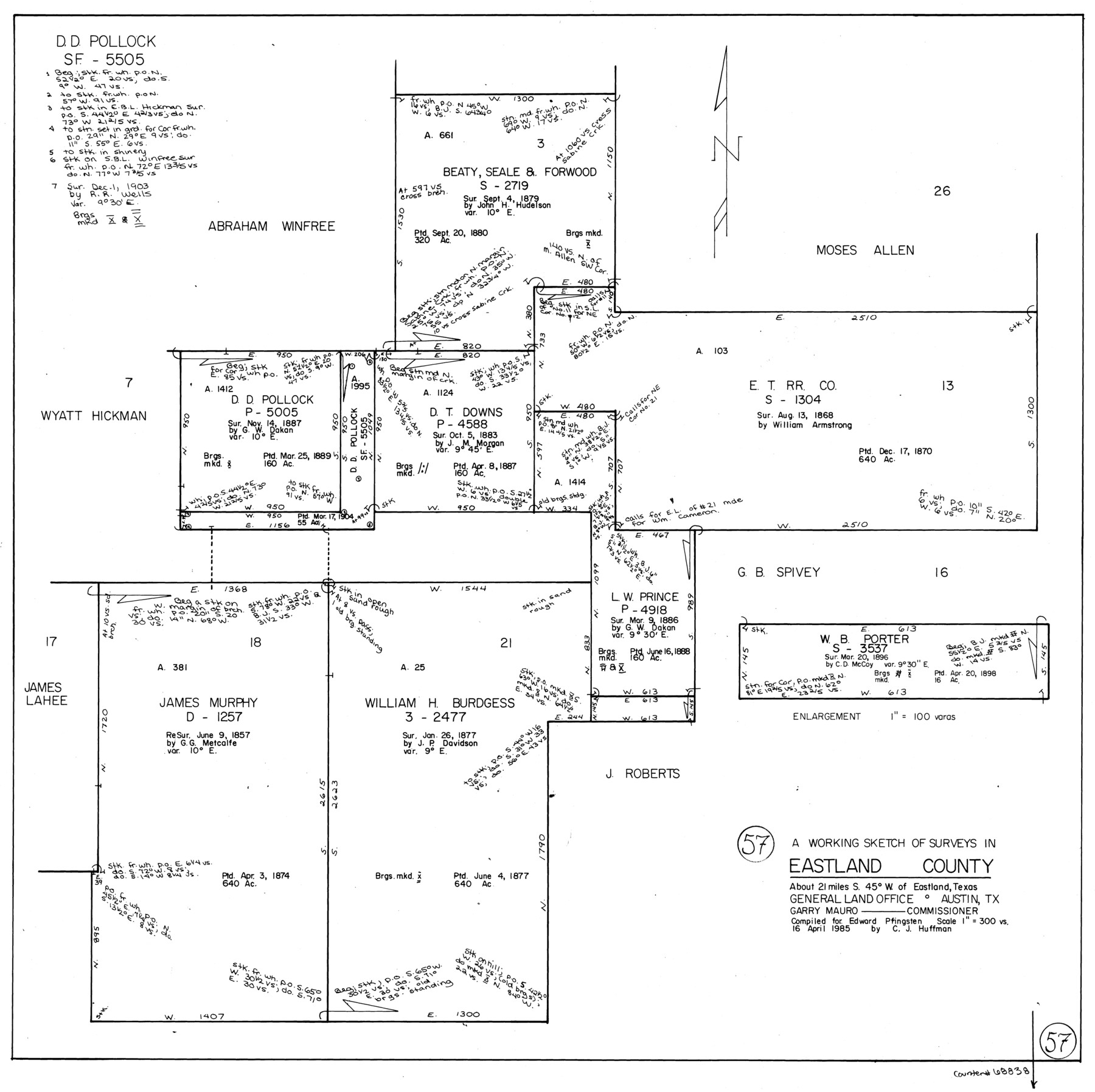
Eastland County Working Sketch 57
-
Map/Doc
68838
-
Collection
General Map Collection
-
Object Dates
4/16/1985 (Creation Date)
-
People and Organizations
C.J. Huffman (Draftsman)
-
Counties
Eastland
-
Subjects
Surveying Working Sketch
-
Height x Width
21.7 x 21.8 inches
55.1 x 55.4 cm
-
Scale
1" = 300 varas
Part of: General Map Collection
Current Miscellaneous File 28

Print $22.00
- Digital $50.00
Current Miscellaneous File 28
1952
Size 10.7 x 16.3 inches
Map/Doc 73911
Morris County Rolled Sketch 2A

Print $20.00
- Digital $50.00
Morris County Rolled Sketch 2A
Size 35.2 x 27.7 inches
Map/Doc 10270
Upshur County Working Sketch 13

Print $20.00
- Digital $50.00
Upshur County Working Sketch 13
1992
Size 29.7 x 42.5 inches
Map/Doc 69570
Map of the Fort Worth & Denver City Railway, Oldham County, Texas

Print $40.00
- Digital $50.00
Map of the Fort Worth & Denver City Railway, Oldham County, Texas
1887
Size 24.8 x 105.2 inches
Map/Doc 64456
Flight Mission No. DQN-5K, Frame 144, Calhoun County

Print $20.00
- Digital $50.00
Flight Mission No. DQN-5K, Frame 144, Calhoun County
1953
Size 18.6 x 22.3 inches
Map/Doc 84419
Louisiana and Texas Intracoastal Waterway

Print $20.00
- Digital $50.00
Louisiana and Texas Intracoastal Waterway
1929
Size 13.7 x 19.0 inches
Map/Doc 83344

Loving County Working Sketch 12

Print $40.00
- Digital $50.00
Loving County Working Sketch 12
1957
Size 48.1 x 37.1 inches
Map/Doc 70645
Map of the Southern Pacific Rail Road through Harrison County, Texas

Print $40.00
- Digital $50.00
Map of the Southern Pacific Rail Road through Harrison County, Texas
1860
Size 26.8 x 76.6 inches
Map/Doc 64140
Concho County Boundary File 1

Print $36.00
- Digital $50.00
Concho County Boundary File 1
Size 14.3 x 8.6 inches
Map/Doc 51805
Current Miscellaneous File 112

Print $138.00
- Digital $50.00
Current Miscellaneous File 112
Size 11.3 x 8.7 inches
Map/Doc 74718
No. 2 Chart of Corpus Christi Pass, Texas

Print $20.00
- Digital $50.00
No. 2 Chart of Corpus Christi Pass, Texas
1878
Size 18.2 x 27.1 inches
Map/Doc 73025
You may also like
Bandera County Boundary File 5

Print $44.00
- Digital $50.00
Bandera County Boundary File 5
Size 14.2 x 8.7 inches
Map/Doc 50299
[Sketch for Mineral Application 26649-26650 - Sabine River, Harry A. Wolan]
![65565, [Sketch for Mineral Application 26649-26650 - Sabine River, Harry A. Wolan], General Map Collection](https://historictexasmaps.com/wmedia_w700/maps/65565.tif.jpg)
Print $40.00
- Digital $50.00
[Sketch for Mineral Application 26649-26650 - Sabine River, Harry A. Wolan]
Size 36.8 x 71.9 inches
Map/Doc 65565
Coke County Sketch File 21

Print $20.00
- Digital $50.00
Coke County Sketch File 21
1911
Size 12.6 x 14.0 inches
Map/Doc 18614
Val Verde County Sketch File XXX8

Print $6.00
- Digital $50.00
Val Verde County Sketch File XXX8
Size 9.0 x 16.4 inches
Map/Doc 39106
Uvalde County Working Sketch 61

Print $20.00
- Digital $50.00
Uvalde County Working Sketch 61
1978
Size 40.4 x 37.4 inches
Map/Doc 72131
Blanco County Working Sketch 22

Print $20.00
- Digital $50.00
Blanco County Working Sketch 22
1962
Size 41.0 x 36.5 inches
Map/Doc 67382
Potter County Sketch File 14

Print $20.00
- Digital $50.00
Potter County Sketch File 14
Size 16.5 x 22.5 inches
Map/Doc 12200
[Beaumont, Sour Lake and Western Ry. Right of Way and Alignment - Frisco]
![64129, [Beaumont, Sour Lake and Western Ry. Right of Way and Alignment - Frisco], General Map Collection](https://historictexasmaps.com/wmedia_w700/maps/64129.tif.jpg)
Print $20.00
- Digital $50.00
[Beaumont, Sour Lake and Western Ry. Right of Way and Alignment - Frisco]
1910
Size 20.1 x 45.9 inches
Map/Doc 64129
Flight Mission No. CUG-1P, Frame 41, Kleberg County

Print $20.00
- Digital $50.00
Flight Mission No. CUG-1P, Frame 41, Kleberg County
1956
Size 18.7 x 22.3 inches
Map/Doc 86119
Engineer's Office, Department of the Gulf Map No. 59, Texas prepared by order of Maj. Gen. N. P. Banks under direction of Capt. P. C. Hains, U. S. Engr. & Chief Engr., Dept. of the Gulf

Print $20.00
- Digital $50.00
Engineer's Office, Department of the Gulf Map No. 59, Texas prepared by order of Maj. Gen. N. P. Banks under direction of Capt. P. C. Hains, U. S. Engr. & Chief Engr., Dept. of the Gulf
1865
Size 18.2 x 27.5 inches
Map/Doc 72716

Gregg County Sketch File 16

Print $6.00
- Digital $50.00
Gregg County Sketch File 16
1931
Size 17.0 x 11.0 inches
Map/Doc 24619