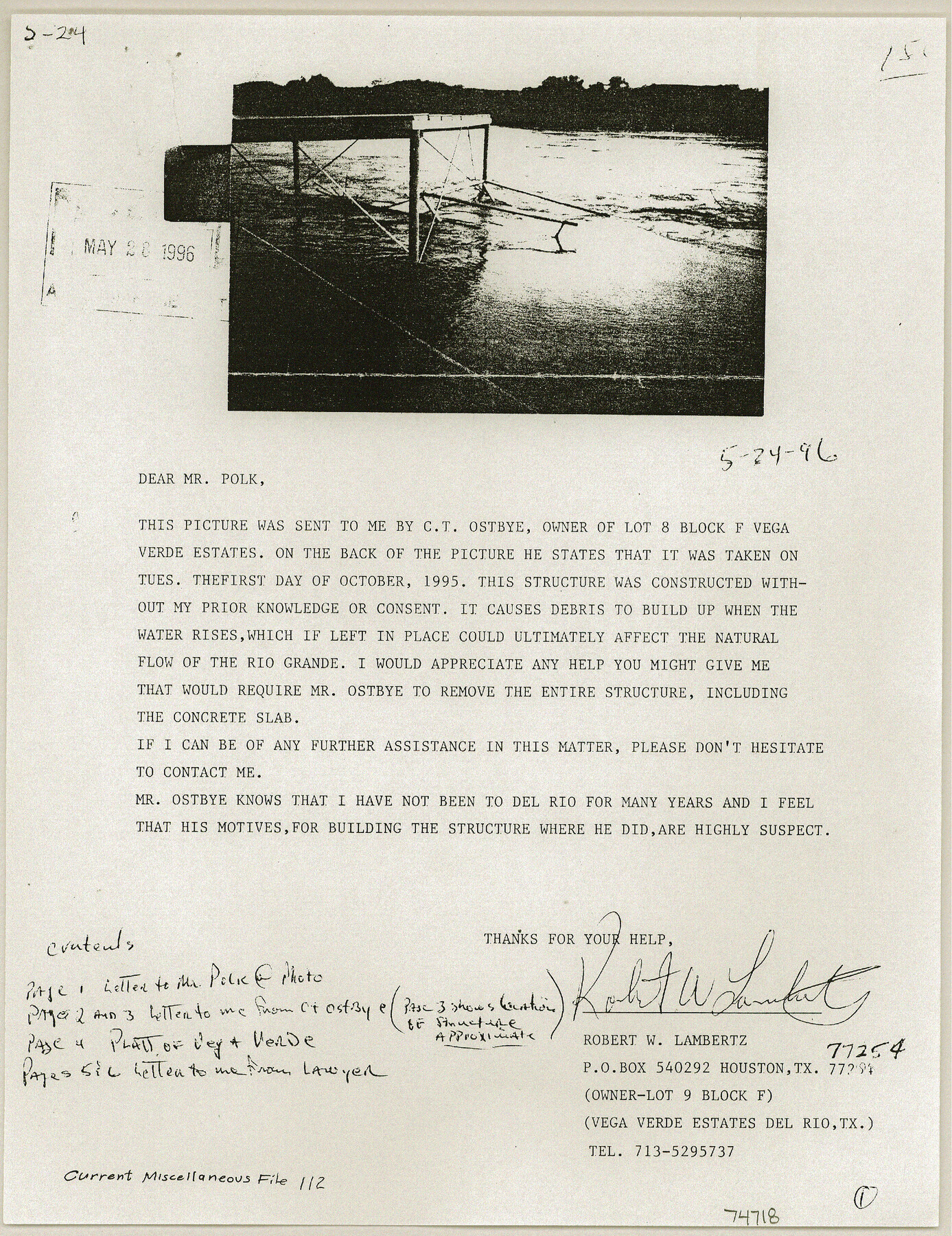
Current Miscellaneous File 112
Ownership of Rio Grande, Val Verde, Texas
- 
                          Map/Doc
74718
 - 
                            Collection
General Map Collection
 - 
                            People and Organizations
LaNell Aston (Author)
 - 
                            Subjects
River Surveys
 - 
                            Height x Width
11.3 x 8.7 inches
28.7 x 22.1 cm
 
Part of: General Map Collection
            Loving County Working Sketch 7


                                            Print $20.00                    
                                             -                         Digital $50.00                                    
                Loving County Working Sketch 7
1949
Size 23.4 x 26.3 inches
                                Map/Doc 70639
            
            Map of Hamilton County


                                            Print $20.00                    
                                             -                         Digital $50.00                                    
                Map of Hamilton County
1863
Size 22.8 x 25.8 inches
                                Map/Doc 3621
            
            Goliad County Sketch File 41


                                            Print $20.00                    
                                             -                         Digital $50.00                                    
                Goliad County Sketch File 41
1958
Size 25.2 x 35.3 inches
                                Map/Doc 11573
            
            Texas Gulf Coast Map from the Sabine River to the Rio Grande as subdivided for mineral development


                                            Print $40.00                    
                                             -                         Digital $50.00                                    
                Texas Gulf Coast Map from the Sabine River to the Rio Grande as subdivided for mineral development
Size 117.9 x 46.0 inches
                                Map/Doc 2902
            
            Sutton County Sketch File 43


                                            Print $20.00                    
                                             -                         Digital $50.00                                    
                Sutton County Sketch File 43
Size 29.1 x 12.4 inches
                                Map/Doc 12391
            
            Flight Mission No. DAG-21K, Frame 32, Matagorda County


                                            Print $20.00                    
                                             -                         Digital $50.00                                    
                Flight Mission No. DAG-21K, Frame 32, Matagorda County
1952
Size 18.6 x 22.4 inches
                                Map/Doc 86399
            
            Reeves County Working Sketch 4


                                            Print $20.00                    
                                             -                         Digital $50.00                                    
                Reeves County Working Sketch 4
1922
Size 32.5 x 33.1 inches
                                Map/Doc 63446
            
            Hockley County Rolled Sketch 5


                                            Print $40.00                    
                                             -                         Digital $50.00                                    
                Hockley County Rolled Sketch 5
Size 80.8 x 29.5 inches
                                Map/Doc 9175
            
            Newton County Rolled Sketch 26


                                            Print $397.00                    
                                             -                         Digital $50.00                                    
                Newton County Rolled Sketch 26
1960
Size 10.9 x 15.4 inches
                                Map/Doc 47265
            
            Brewster County Rolled Sketch 83A


                                            Print $40.00                    
                                             -                         Digital $50.00                                    
                Brewster County Rolled Sketch 83A
1946
Size 43.0 x 49.5 inches
                                Map/Doc 8930
            You may also like
            Amerique Septentrionale divisée en ses principales parties


                                            Print $20.00                    
                                             -                         Digital $50.00                                    
                Amerique Septentrionale divisée en ses principales parties
1792
Size 21.3 x 25.9 inches
                                Map/Doc 93916
            
            Presidio County Working Sketch 149


                                            Print $20.00                    
                                             -                         Digital $50.00                                    
                Presidio County Working Sketch 149
2002
Size 24.0 x 24.0 inches
                                Map/Doc 93489
            
            Rockwall County Boundary File 8


                                            Print $10.00                    
                                             -                         Digital $50.00                                    
                Rockwall County Boundary File 8
Size 14.4 x 8.8 inches
                                Map/Doc 58428
            
            Cass County Rolled Sketch OF


                                            Print $20.00                    
                                             -                         Digital $50.00                                    
                Cass County Rolled Sketch OF
1937
Size 16.2 x 24.3 inches
                                Map/Doc 5414
            
            Gillespie County Working Sketch 3


                                            Print $20.00                    
                                             -                         Digital $50.00                                    
                Gillespie County Working Sketch 3
1960
Size 23.0 x 21.7 inches
                                Map/Doc 63166
            
            McLennan County Sketch File 13


                                            Print $4.00                    
                                             -                         Digital $50.00                                    
                McLennan County Sketch File 13
1873
Size 10.7 x 8.1 inches
                                Map/Doc 31267
            
            [Subdivision Plat of 80 acres]


                                            Print $2.00                    
                                             -                         Digital $50.00                                    
                [Subdivision Plat of 80 acres]
Size 10.6 x 6.3 inches
                                Map/Doc 93074
            
            Flight Mission No. DAG-24K, Frame 159, Matagorda County


                                            Print $20.00                    
                                             -                         Digital $50.00                                    
                Flight Mission No. DAG-24K, Frame 159, Matagorda County
1953
Size 17.2 x 19.1 inches
                                Map/Doc 86573
            
            [Sketch of Sullivan Property]


                                            Print $20.00                    
                                             -                         Digital $50.00                                    
                [Sketch of Sullivan Property]
Size 14.3 x 22.7 inches
                                Map/Doc 75775
            
            General Highway Map, Culberson County, Texas


                                            Print $20.00                    
                                    
                General Highway Map, Culberson County, Texas
1940
Size 25.2 x 18.5 inches
                                Map/Doc 79064
            
            Castro County Sketch File 17


                                            Print $20.00                    
                                             -                         Digital $50.00                                    
                Castro County Sketch File 17
1981
Size 14.8 x 25.7 inches
                                Map/Doc 11063
            
            Map of Limestone County


                                            Print $20.00                    
                                             -                         Digital $50.00                                    
                Map of Limestone County
1858
Size 23.2 x 23.8 inches
                                Map/Doc 3819