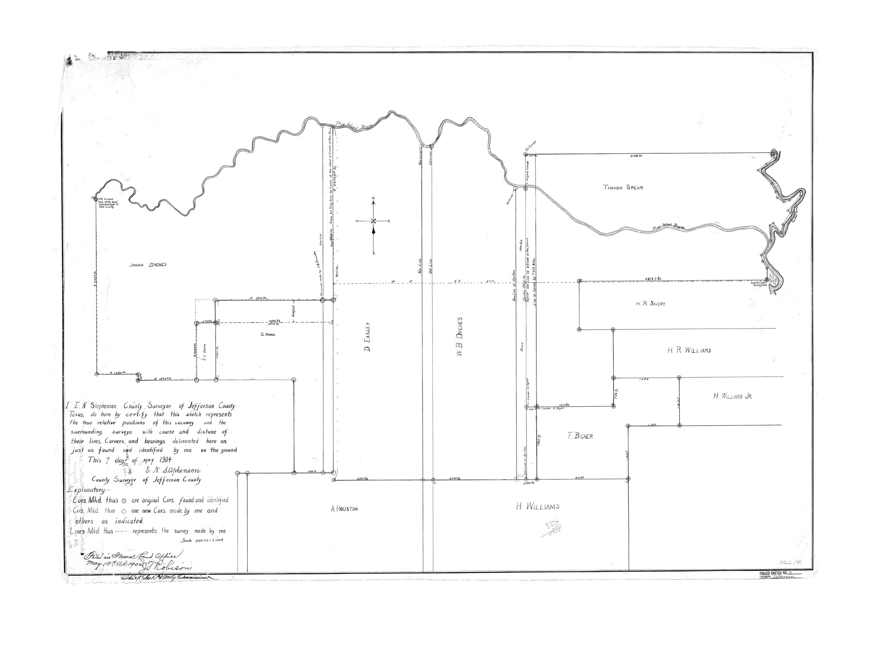
Jefferson County Rolled Sketch 2
[Sketch on Pine Island Bayou, Jefferson County, Texas]
-
Map/Doc
6383
-
Collection
General Map Collection
-
Object Dates
1904/5/7 (Creation Date)
1904/5/10 (File Date)
-
People and Organizations
E.N. Stephenson (Surveyor/Engineer)
-
Counties
Jefferson
-
Subjects
Surveying Rolled Sketch
-
Height x Width
33.1 x 44.7 inches
84.1 x 113.5 cm
-
Scale
1" = 500 varas
Part of: General Map Collection
Ochiltree County Boundary File 1a

Print $4.00
- Digital $50.00
Ochiltree County Boundary File 1a
Size 11.0 x 8.5 inches
Map/Doc 57664
Cochran County Sketch File 7

Print $10.00
- Digital $50.00
Cochran County Sketch File 7
1940
Size 11.2 x 8.6 inches
Map/Doc 18550
McMullen County Rolled Sketch 7

Print $40.00
- Digital $50.00
McMullen County Rolled Sketch 7
1939
Size 38.8 x 51.7 inches
Map/Doc 9500
Gaines County Sketch File 13

Print $40.00
- Digital $50.00
Gaines County Sketch File 13
1954
Size 8.9 x 20.4 inches
Map/Doc 23200
Presidio County Rolled Sketch 63

Print $20.00
- Digital $50.00
Presidio County Rolled Sketch 63
Size 21.6 x 21.3 inches
Map/Doc 7355
Cameron County Rolled Sketch 19

Print $20.00
- Digital $50.00
Cameron County Rolled Sketch 19
Size 25.8 x 23.6 inches
Map/Doc 5465
Skeleton Map Showing the Rail Roads Completed and in progress in the United States, and those projected through the Public Lands and their connection with the principal Harbours on the Lakes and on the Seaboard

Print $40.00
- Digital $50.00
Skeleton Map Showing the Rail Roads Completed and in progress in the United States, and those projected through the Public Lands and their connection with the principal Harbours on the Lakes and on the Seaboard
Size 49.1 x 39.8 inches
Map/Doc 95699
Map of Nacogdoches County

Print $40.00
- Digital $50.00
Map of Nacogdoches County
1839
Size 83.6 x 41.6 inches
Map/Doc 93371
Hardeman County Sketch File 17

Print $2.00
- Digital $50.00
Hardeman County Sketch File 17
Size 7.8 x 6.7 inches
Map/Doc 25025
Right of Way and Track Map, International & Gt. Northern Ry. Operated by the International & Gt. Northern Ry. Co., Gulf Division

Print $40.00
- Digital $50.00
Right of Way and Track Map, International & Gt. Northern Ry. Operated by the International & Gt. Northern Ry. Co., Gulf Division
1917
Size 25.1 x 56.6 inches
Map/Doc 64252
Map of Darrington State Farm, Brazoria County, Texas

Print $20.00
- Digital $50.00
Map of Darrington State Farm, Brazoria County, Texas
Size 18.5 x 37.9 inches
Map/Doc 62985
Gregg County Rolled Sketch 14

Print $20.00
- Digital $50.00
Gregg County Rolled Sketch 14
1940
Size 42.4 x 14.1 inches
Map/Doc 6037
You may also like
University Land Field Notes for Block L in El Paso County

University Land Field Notes for Block L in El Paso County
Map/Doc 81725
Kent County Sketch File 15

Print $8.00
- Digital $50.00
Kent County Sketch File 15
1936
Size 11.4 x 7.2 inches
Map/Doc 28842
Kaufman County State Real Property Sketch 2

Print $20.00
- Digital $50.00
Kaufman County State Real Property Sketch 2
2007
Size 24.2 x 35.4 inches
Map/Doc 88672
Anderson County

Print $20.00
- Digital $50.00
Anderson County
1861
Size 18.0 x 21.2 inches
Map/Doc 774
Upton County Rolled Sketch 26

Print $20.00
- Digital $50.00
Upton County Rolled Sketch 26
1942
Size 35.7 x 37.2 inches
Map/Doc 10045
Coke County Working Sketch 4

Print $20.00
- Digital $50.00
Coke County Working Sketch 4
1897
Size 15.6 x 16.4 inches
Map/Doc 68041
Hudspeth County Rolled Sketch 40

Print $20.00
- Digital $50.00
Hudspeth County Rolled Sketch 40
1937
Size 11.5 x 38.9 inches
Map/Doc 9213
El Paso County Boundary File 25

Print $10.00
- Digital $50.00
El Paso County Boundary File 25
Size 13.0 x 8.9 inches
Map/Doc 53226
Flight Mission No. DQO-8K, Frame 52, Galveston County

Print $20.00
- Digital $50.00
Flight Mission No. DQO-8K, Frame 52, Galveston County
1952
Size 18.6 x 22.2 inches
Map/Doc 85159
Castro County Sketch File 1

Print $6.00
- Digital $50.00
Castro County Sketch File 1
1890
Size 8.8 x 7.8 inches
Map/Doc 17451
Duval County Boundary File 3c

Print $12.00
- Digital $50.00
Duval County Boundary File 3c
Size 11.7 x 8.4 inches
Map/Doc 52732
Flight Mission No. BQY-14M, Frame 184, Harris County

Print $20.00
- Digital $50.00
Flight Mission No. BQY-14M, Frame 184, Harris County
1953
Size 18.6 x 22.4 inches
Map/Doc 85300