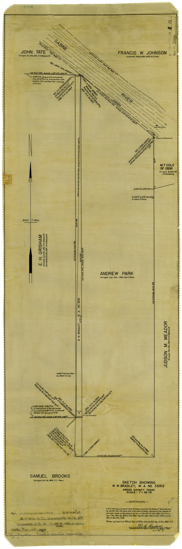
Gregg County Rolled Sketch 14
Sketch showing W.W. Bradley, MA. No. 35312
-
Map/Doc
6037
-
Collection
General Map Collection
-
Object Dates
11/12/1940 (Creation Date)
11/16/1940 (File Date)
-
People and Organizations
M.H. Hackney (Surveyor/Engineer)
-
Counties
Gregg
-
Subjects
Surveying Rolled Sketch
-
Height x Width
42.4 x 14.1 inches
107.7 x 35.8 cm
-
Medium
paper, manuscript
-
Scale
1" = 36 varas
Part of: General Map Collection

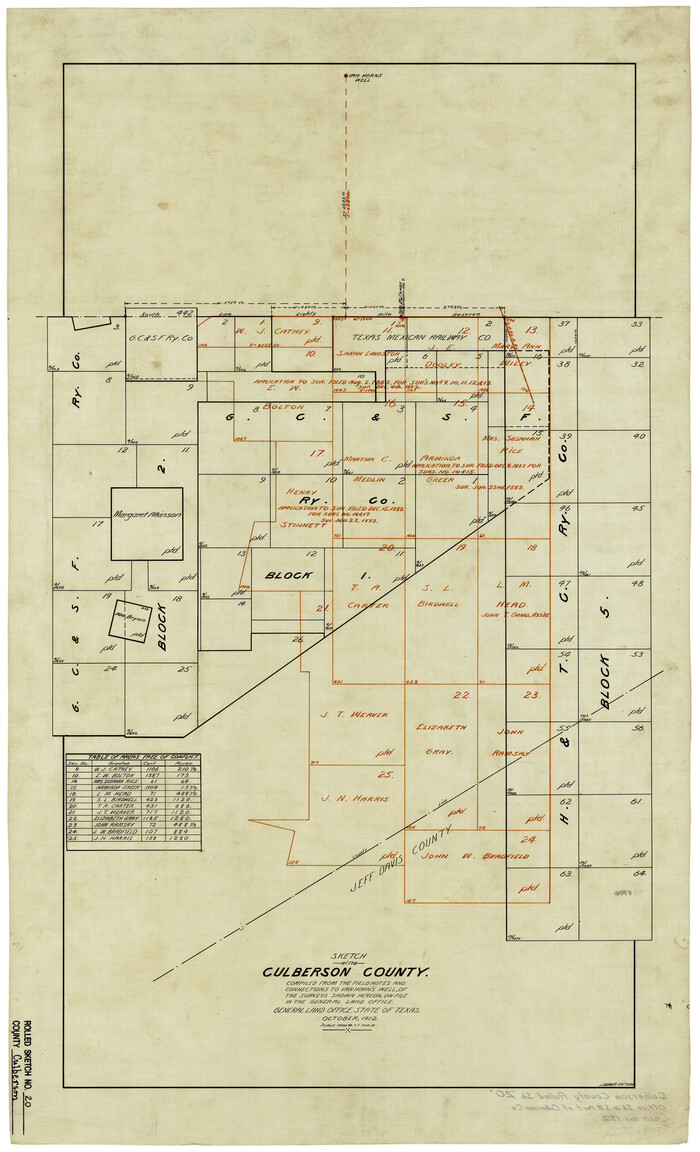
Culberson County Working Sketch 87

Print $20.00
- Digital $50.00
Culberson County Working Sketch 87
1981
Size 26.9 x 37.1 inches
Map/Doc 68541
Reagan County Sketch File 3

Print $20.00
- Digital $50.00
Reagan County Sketch File 3
Size 18.0 x 21.9 inches
Map/Doc 12213
Donley County Boundary File 7

Print $31.00
- Digital $50.00
Donley County Boundary File 7
Size 11.3 x 8.6 inches
Map/Doc 52640
Culberson County Working Sketch 50

Print $20.00
- Digital $50.00
Culberson County Working Sketch 50
1972
Size 32.0 x 35.1 inches
Map/Doc 68504
Pecos County Rolled Sketch 82

Print $20.00
- Digital $50.00
Pecos County Rolled Sketch 82
1930
Size 29.6 x 27.1 inches
Map/Doc 8371
Flight Mission No. BQR-14K, Frame 40, Brazoria County

Print $20.00
- Digital $50.00
Flight Mission No. BQR-14K, Frame 40, Brazoria County
1952
Size 18.7 x 22.3 inches
Map/Doc 84097
Culberson County Rolled Sketch 20
Print $20.00
- Digital $50.00
Culberson County Rolled Sketch 20
1912
Size 30.0 x 18.2 inches
Map/Doc 5653
Freestone County Rolled Sketch 14

Print $20.00
- Digital $50.00
Freestone County Rolled Sketch 14
Size 29.4 x 19.8 inches
Map/Doc 78601

Garza County Rolled Sketch 17

Print $20.00
- Digital $50.00
Garza County Rolled Sketch 17
1959
Size 32.3 x 37.6 inches
Map/Doc 6003
Newton County Working Sketch 39

Print $20.00
- Digital $50.00
Newton County Working Sketch 39
1961
Size 36.6 x 41.0 inches
Map/Doc 71285
You may also like
Houston County Working Sketch 25

Print $40.00
- Digital $50.00
Houston County Working Sketch 25
1983
Size 43.6 x 89.0 inches
Map/Doc 66255
Gulf of Mexico

Print $20.00
- Digital $50.00
Gulf of Mexico
1900
Size 18.2 x 28.1 inches
Map/Doc 72647
Hunt County Working Sketch 2

Print $20.00
- Digital $50.00
Hunt County Working Sketch 2
Size 20.5 x 16.5 inches
Map/Doc 66349
McMullen County Sketch File 4

Print $4.00
- Digital $50.00
McMullen County Sketch File 4
Size 7.9 x 10.1 inches
Map/Doc 31341
Cass County Working Sketch 18

Print $20.00
- Digital $50.00
Cass County Working Sketch 18
1958
Size 24.2 x 44.3 inches
Map/Doc 67921
From the Red River to the Rio Grande from explorations and surveys made under the direction of the Hon. Jefferson Davis, Secretary of War by Captain John Pope, Corps Topl. Engrs. assisted by Lieutenant Kenner Gerrard, 1st Dragoons, 1854-6

Print $40.00
From the Red River to the Rio Grande from explorations and surveys made under the direction of the Hon. Jefferson Davis, Secretary of War by Captain John Pope, Corps Topl. Engrs. assisted by Lieutenant Kenner Gerrard, 1st Dragoons, 1854-6
1859
Size 28.0 x 57.9 inches
Map/Doc 93581
Harris County Sketch File 1b

Print $3.00
- Digital $50.00
Harris County Sketch File 1b
Size 15.3 x 10.4 inches
Map/Doc 25330
Dickens County Rolled Sketch P2

Print $20.00
- Digital $50.00
Dickens County Rolled Sketch P2
1917
Size 41.5 x 36.4 inches
Map/Doc 8784
Northern Part of Laguna Madre

Print $20.00
- Digital $50.00
Northern Part of Laguna Madre
1992
Size 45.4 x 35.3 inches
Map/Doc 73532
General Highway Map. Detail of Cities and Towns in Falls County, Texas

Print $20.00
General Highway Map. Detail of Cities and Towns in Falls County, Texas
1961
Size 18.1 x 24.4 inches
Map/Doc 79463
Phelps's National Map of the United States, a Travellers Guide. Embracing the principal railroads, canals, steamboat & stage routes, throughout the Union

Print $20.00
- Digital $50.00
Phelps's National Map of the United States, a Travellers Guide. Embracing the principal railroads, canals, steamboat & stage routes, throughout the Union
1849
Size 20.9 x 26.3 inches
Map/Doc 95901
Newton County Working Sketch 37

Print $20.00
- Digital $50.00
Newton County Working Sketch 37
1960
Size 31.7 x 22.7 inches
Map/Doc 71283