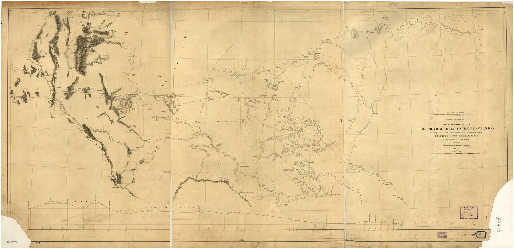
From the Red River to the Rio Grande from explorations and surveys made under the direction of the Hon. Jefferson Davis, Secretary of War by Captain John Pope, Corps Topl. Engrs. assisted by Lieutenant Kenner Gerrard, 1st Dragoons, 1854-6
-
Map/Doc
93581
-
Collection
Library of Congress
-
Object Dates
1859 (Creation Date)
-
People and Organizations
John Pope (Surveyor/Engineer)
-
Subjects
Military
-
Height x Width
28.0 x 57.9 inches
71.1 x 147.1 cm
-
Comments
For more information see here. Prints available from the GLO courtesy of Library of Congress, Geography and Map Division.
Part of: Library of Congress
Plano del Lago de Sn. Bernardo situado en la costa del N. del Seno Mexicano su entrada en la L. N. de 28° 24' y en la Long. de 278° 27' segun el Meridiano de Tenerife

Print $20.00
Plano del Lago de Sn. Bernardo situado en la costa del N. del Seno Mexicano su entrada en la L. N. de 28° 24' y en la Long. de 278° 27' segun el Meridiano de Tenerife
Size 7.9 x 17.3 inches
Map/Doc 93616
[Map showing T&P Lands in El Paso County]
![88932, [Map showing T&P Lands in El Paso County], Library of Congress](https://historictexasmaps.com/wmedia_w700/maps/88932.tif.jpg)
Print $20.00
[Map showing T&P Lands in El Paso County]
Size 22.2 x 17.1 inches
Map/Doc 88932

Houston - a Modern City

Print $20.00
Houston - a Modern City
1912
Size 18.2 x 23.4 inches
Map/Doc 93482
![88940, Fisher Co[unty], Library of Congress](https://historictexasmaps.com/wmedia_w700/maps/88940.tif.jpg)


![88993, San Jacinto Co[unty], Library of Congress](https://historictexasmaps.com/wmedia_w700/maps/88993.tif.jpg)

Pocket Map Showing the Railroads, Street Railways, Manufactories, Deep Water Connections, Blocks and Subdivisions of the City of Houston

Print $20.00
Pocket Map Showing the Railroads, Street Railways, Manufactories, Deep Water Connections, Blocks and Subdivisions of the City of Houston
1890
Size 35.5 x 29.8 inches
Map/Doc 93487
Provincias internas del reyno de Nuevo España

Print $20.00
Provincias internas del reyno de Nuevo España
1846
Size 30.7 x 23.6 inches
Map/Doc 93578
You may also like
Val Verde County Sketch File 52a

Print $20.00
- Digital $50.00
Val Verde County Sketch File 52a
1885
Size 21.5 x 22.1 inches
Map/Doc 12592
Flight Mission No. DCL-6C, Frame 77, Kenedy County

Print $20.00
- Digital $50.00
Flight Mission No. DCL-6C, Frame 77, Kenedy County
1943
Size 18.5 x 22.3 inches
Map/Doc 85919
United States - Gulf Coast Texas - Southern part of Laguna Madre

Print $20.00
- Digital $50.00
United States - Gulf Coast Texas - Southern part of Laguna Madre
1933
Size 26.8 x 18.3 inches
Map/Doc 72949
Presidio County Working Sketch 119

Print $20.00
- Digital $50.00
Presidio County Working Sketch 119
1983
Size 36.7 x 37.1 inches
Map/Doc 71796
From Citizens Living in Red River County for the Creation of a New County (Unnamed), Undated

Print $20.00
From Citizens Living in Red River County for the Creation of a New County (Unnamed), Undated
2020
Size 16.6 x 21.7 inches
Map/Doc 96405
Kent County Boundary File 4b

Print $36.00
- Digital $50.00
Kent County Boundary File 4b
Size 14.2 x 8.7 inches
Map/Doc 55847
Grimes County Working Sketch 7

Print $20.00
- Digital $50.00
Grimes County Working Sketch 7
1963
Size 27.2 x 33.0 inches
Map/Doc 63298
Hudspeth County Rolled Sketch 30

Print $20.00
- Digital $50.00
Hudspeth County Rolled Sketch 30
1924
Size 36.0 x 47.3 inches
Map/Doc 9210
Dawson County, Texas

Print $20.00
- Digital $50.00
Dawson County, Texas
Size 16.0 x 18.1 inches
Map/Doc 92620
Montgomery County Rolled Sketch 10

Print $20.00
- Digital $50.00
Montgomery County Rolled Sketch 10
1905
Size 35.5 x 26.2 inches
Map/Doc 6796
Duval County Working Sketch 3

Print $40.00
- Digital $50.00
Duval County Working Sketch 3
1925
Size 59.1 x 45.0 inches
Map/Doc 76444
Map showing connection of land-lines with M. & P. E. Ry. through Uvalde Co.

Print $40.00
- Digital $50.00
Map showing connection of land-lines with M. & P. E. Ry. through Uvalde Co.
1882
Size 11.8 x 86.3 inches
Map/Doc 64179