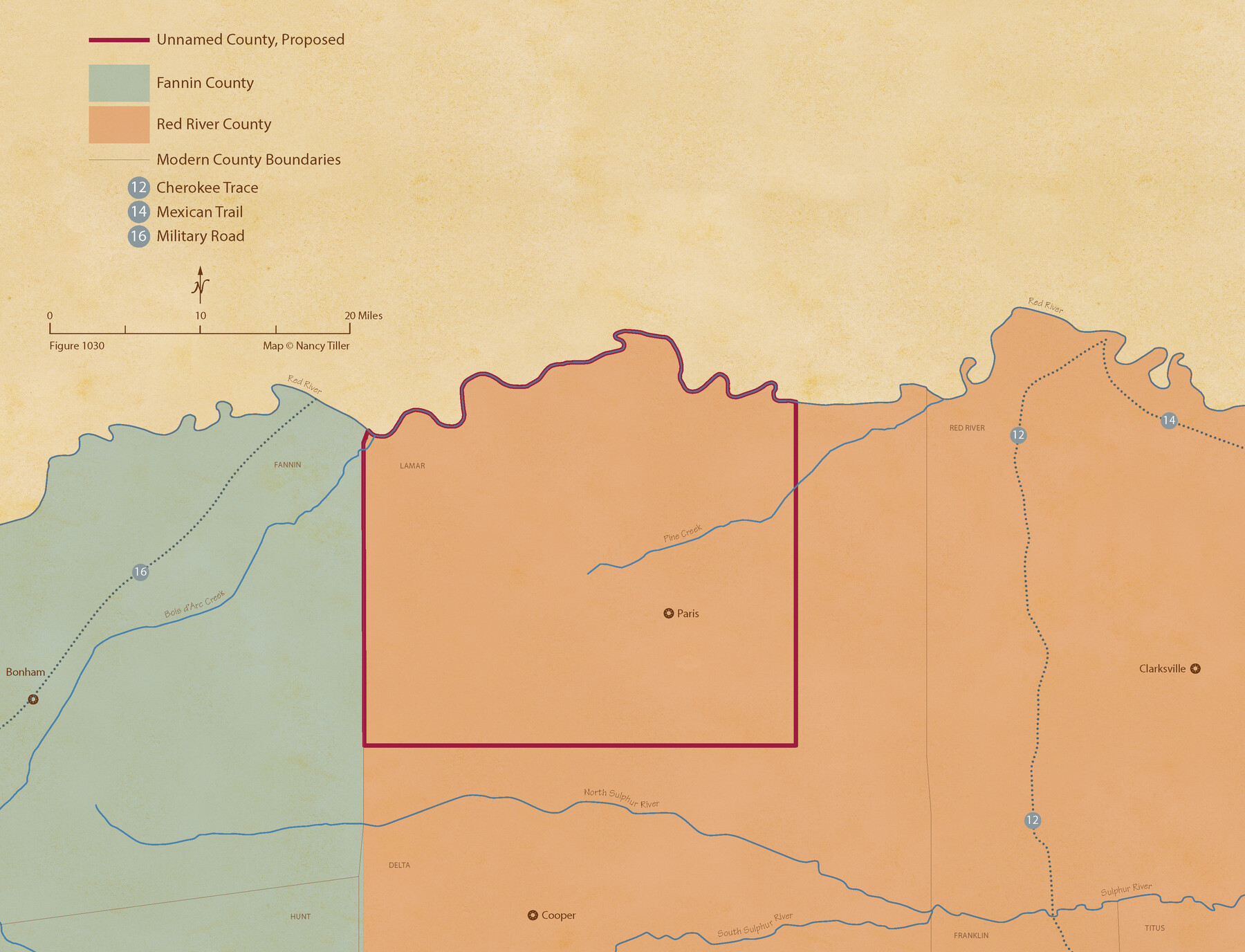
From Citizens Living in Red River County for the Creation of a New County (Unnamed), Undated
Figure No. 1030 from 'A Boundary Atlas of Texas, 1821-1845' by Jim Tiller
-
Map/Doc
96405
-
Collection
Nancy and Jim Tiller Digital Collection
-
Object Dates
2020/1/1 (Creation Date)
-
People and Organizations
Jim Tiller (Author)
Nancy Tiller (Cartographer)
Gang Gong (GIS Professional)
-
Subjects
Atlas Republic of Texas Texas Boundaries
-
Height x Width
8.3 x 10.8 inches
21.1 x 27.4 cm
-
Medium
digital image
-
Comments
To purchase a digital PDF copy of "A Boundary Atlas of Texas, 1821-1845" see 96437.
Part of: Nancy and Jim Tiller Digital Collection
The Peters Colony. August 30, 1841
![96362, The Peters Colony. August 30, 1841, Nancy and Jim Tiller Digital Collection](https://historictexasmaps.com/wmedia_w700/maps/96362.tif.jpg)
Print $20.00
- Digital $50.00
The Peters Colony. August 30, 1841
2020
Size 10.8 x 10.8 inches
Map/Doc 96362
The Republic County of Refugio. December 29, 1845
![96258, The Republic County of Refugio. December 29, 1845, Nancy and Jim Tiller Digital Collection](https://historictexasmaps.com/wmedia_w700/maps/96258.tif.jpg)
Print $20.00
- Digital $50.00
The Republic County of Refugio. December 29, 1845
2020
Size 11.1 x 10.8 inches
Map/Doc 96258
Austin Empresario Colony. November 20, 1827
![95981, Austin Empresario Colony. November 20, 1827, Nancy and Jim Tiller Digital Collection](https://historictexasmaps.com/wmedia_w700/maps/95981.tif.jpg)
Print $20.00
- Digital $50.00
Austin Empresario Colony. November 20, 1827
2020
Size 7.4 x 10.8 inches
Map/Doc 95981
The Republic County of Lamar. Created, December 17, 1840
![96202, The Republic County of Lamar. Created, December 17, 1840, Nancy and Jim Tiller Digital Collection](https://historictexasmaps.com/wmedia_w700/maps/96202.tif.jpg)
Print $20.00
- Digital $50.00
The Republic County of Lamar. Created, December 17, 1840
2020
Size 8.2 x 10.8 inches
Map/Doc 96202
The Peters Colony. January 29, 1844
![96366, The Peters Colony. January 29, 1844, Nancy and Jim Tiller Digital Collection](https://historictexasmaps.com/wmedia_w700/maps/96366.tif.jpg)
Print $20.00
- Digital $50.00
The Peters Colony. January 29, 1844
2020
Size 8.6 x 10.8 inches
Map/Doc 96366
The Republic County of Jackson. Boundaries Defined, December 29, 1837
![96184, The Republic County of Jackson. Boundaries Defined, December 29, 1837, Nancy and Jim Tiller Digital Collection](https://historictexasmaps.com/wmedia_w700/maps/96184.tif.jpg)
Print $20.00
- Digital $50.00
The Republic County of Jackson. Boundaries Defined, December 29, 1837
2020
Size 7.8 x 10.9 inches
Map/Doc 96184
The Republic County of Harrison. February 1, 1842
![96172, The Republic County of Harrison. February 1, 1842, Nancy and Jim Tiller Digital Collection](https://historictexasmaps.com/wmedia_w700/maps/96172.tif.jpg)
Print $20.00
- Digital $50.00
The Republic County of Harrison. February 1, 1842
2020
Size 9.3 x 10.8 inches
Map/Doc 96172
The Peters Colony. January 20, 1843
![96365, The Peters Colony. January 20, 1843, Nancy and Jim Tiller Digital Collection](https://historictexasmaps.com/wmedia_w700/maps/96365.tif.jpg)
Print $20.00
- Digital $50.00
The Peters Colony. January 20, 1843
2020
Size 8.6 x 10.8 inches
Map/Doc 96365
The Land Offices. No. 8, Mina, December 22, 1836
![96421, The Land Offices. No. 8, Mina, December 22, 1836, Nancy and Jim Tiller Digital Collection](https://historictexasmaps.com/wmedia_w700/maps/96421.tif.jpg)
Print $20.00
- Digital $50.00
The Land Offices. No. 8, Mina, December 22, 1836
2020
Size 10.0 x 10.8 inches
Map/Doc 96421
The Land Offices. No. 11, Victoria, December 22, 1836
![96424, The Land Offices. No. 11, Victoria, December 22, 1836, Nancy and Jim Tiller Digital Collection](https://historictexasmaps.com/wmedia_w700/maps/96424.tif.jpg)
Print $20.00
- Digital $50.00
The Land Offices. No. 11, Victoria, December 22, 1836
2020
Size 10.9 x 10.8 inches
Map/Doc 96424
The Mexican Municipality of Matagorda. Created, March 6, 1834
![96025, The Mexican Municipality of Matagorda. Created, March 6, 1834, Nancy and Jim Tiller Digital Collection](https://historictexasmaps.com/wmedia_w700/maps/96025.tif.jpg)
Print $20.00
- Digital $50.00
The Mexican Municipality of Matagorda. Created, March 6, 1834
2020
Size 7.9 x 10.8 inches
Map/Doc 96025
The Peters Colony. July 26, 1842
![96364, The Peters Colony. July 26, 1842, Nancy and Jim Tiller Digital Collection](https://historictexasmaps.com/wmedia_w700/maps/96364.tif.jpg)
Print $20.00
- Digital $50.00
The Peters Colony. July 26, 1842
2020
Size 10.8 x 10.8 inches
Map/Doc 96364
You may also like
[Block 28, Showing Edwards Ranch]
![91499, [Block 28, Showing Edwards Ranch], Twichell Survey Records](https://historictexasmaps.com/wmedia_w700/maps/91499-1.tif.jpg)
Print $3.00
- Digital $50.00
[Block 28, Showing Edwards Ranch]
Size 17.0 x 8.9 inches
Map/Doc 91499
Grimes County Sketch File 4
![24635, Grimes County Sketch File 4, General Map Collection](https://historictexasmaps.com/wmedia_w700/pdf_converted_jpg/qi_pdf_thumbnail_11509.jpg)
Print $4.00
- Digital $50.00
Grimes County Sketch File 4
1872
Size 12.7 x 8.0 inches
Map/Doc 24635
Hardin County Working Sketch 2
![63400, Hardin County Working Sketch 2, General Map Collection](https://historictexasmaps.com/wmedia_w700/maps/63400.tif.jpg)
Print $20.00
- Digital $50.00
Hardin County Working Sketch 2
Size 23.2 x 21.9 inches
Map/Doc 63400
Flight Mission No. BRA-7M, Frame 191, Jefferson County
![85559, Flight Mission No. BRA-7M, Frame 191, Jefferson County, General Map Collection](https://historictexasmaps.com/wmedia_w700/pdf_converted_jpg/qi_pdf_thumbnail_32758.jpg)
Print $20.00
- Digital $50.00
Flight Mission No. BRA-7M, Frame 191, Jefferson County
1953
Size 18.6 x 22.4 inches
Map/Doc 85559
Callahan County Working Sketch 8
![67890, Callahan County Working Sketch 8, General Map Collection](https://historictexasmaps.com/wmedia_w700/maps/67890.tif.jpg)
Print $20.00
- Digital $50.00
Callahan County Working Sketch 8
Size 30.5 x 23.7 inches
Map/Doc 67890
Edwards-Kinney County Line, Field Notes & Correspondence, 1933
![62881, Edwards-Kinney County Line, Field Notes & Correspondence, 1933, General Map Collection](https://historictexasmaps.com/wmedia_w700/pdf_converted_jpg/qi_pdf_thumbnail_17823.jpg)
Print $42.00
- Digital $50.00
Edwards-Kinney County Line, Field Notes & Correspondence, 1933
1931
Size 11.2 x 8.7 inches
Map/Doc 62881
Flight Mission No. DQO-1K, Frame 93, Galveston County
![84989, Flight Mission No. DQO-1K, Frame 93, Galveston County, General Map Collection](https://historictexasmaps.com/wmedia_w700/pdf_converted_jpg/qi_pdf_thumbnail_32201.jpg)
Print $20.00
- Digital $50.00
Flight Mission No. DQO-1K, Frame 93, Galveston County
1952
Size 18.9 x 22.5 inches
Map/Doc 84989
Nueces County Rolled Sketch 36
![47617, Nueces County Rolled Sketch 36, General Map Collection](https://historictexasmaps.com/wmedia_w700/pdf_converted_jpg/qi_pdf_thumbnail_15504.jpg)
Print $199.00
- Digital $50.00
Nueces County Rolled Sketch 36
Size 10.7 x 15.2 inches
Map/Doc 47617
Smith County Sketch File 18
![76752, Smith County Sketch File 18, General Map Collection](https://historictexasmaps.com/wmedia_w700/pdf_converted_jpg/qi_pdf_thumbnail_28962.jpg)
Print $42.00
- Digital $50.00
Smith County Sketch File 18
1850
Size 24.8 x 19.3 inches
Map/Doc 76752
[Jesse Folk and Surrounding Surveys]
![91086, [Jesse Folk and Surrounding Surveys], Twichell Survey Records](https://historictexasmaps.com/wmedia_w700/maps/91086-1.tif.jpg)
Print $20.00
- Digital $50.00
[Jesse Folk and Surrounding Surveys]
Size 14.9 x 18.3 inches
Map/Doc 91086
Borden County Working Sketch 7
![67467, Borden County Working Sketch 7, General Map Collection](https://historictexasmaps.com/wmedia_w700/maps/67467.tif.jpg)
Print $20.00
- Digital $50.00
Borden County Working Sketch 7
1947
Size 21.0 x 22.5 inches
Map/Doc 67467
Atascosa County Rolled Sketch 19
![5099, Atascosa County Rolled Sketch 19, General Map Collection](https://historictexasmaps.com/wmedia_w700/maps/5099.tif.jpg)
Print $20.00
- Digital $50.00
Atascosa County Rolled Sketch 19
1955
Size 22.1 x 18.3 inches
Map/Doc 5099