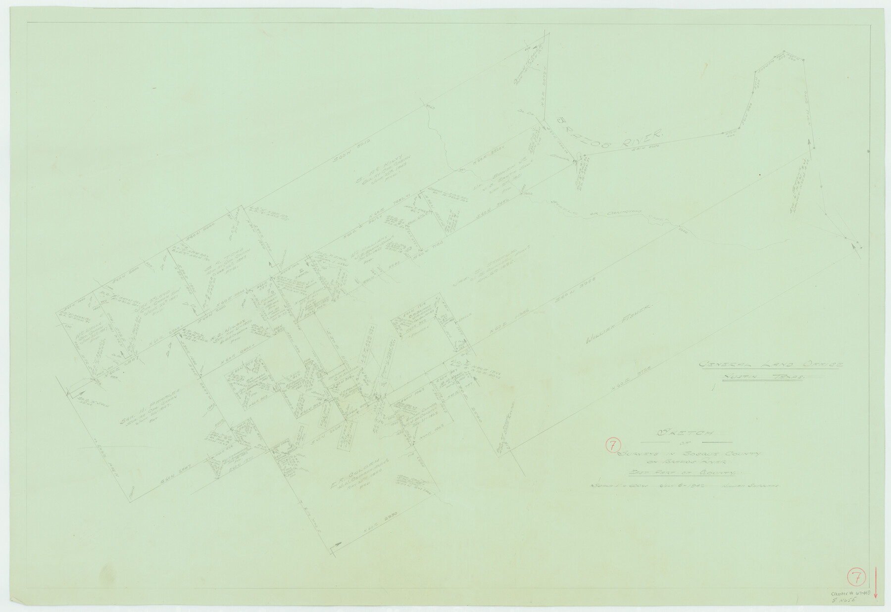
Bosque County Working Sketch 7
-
Map/Doc
67440
-
Collection
General Map Collection
-
Object Dates
7/8/1942 (Creation Date)
-
People and Organizations
William Shirriffs (Draftsman)
-
Counties
Bosque
-
Subjects
Surveying Working Sketch
-
Height x Width
23.7 x 34.5 inches
60.2 x 87.6 cm
-
Scale
1" = 600 varas
-
Comments
Surveys located about eight miles North 65 degrees East of Meridian, Texas.
Part of: General Map Collection
Maverick County Sketch File 3a

Print $34.00
- Digital $50.00
Maverick County Sketch File 3a
Size 10.0 x 8.0 inches
Map/Doc 31035
Matagorda County Rolled Sketch 9

Print $20.00
- Digital $50.00
Matagorda County Rolled Sketch 9
Size 36.8 x 30.0 inches
Map/Doc 6680
Maps of Gulf Intracoastal Waterway, Texas - Sabine River to the Rio Grande and connecting waterways including ship channels

Print $20.00
- Digital $50.00
Maps of Gulf Intracoastal Waterway, Texas - Sabine River to the Rio Grande and connecting waterways including ship channels
1966
Size 14.5 x 22.1 inches
Map/Doc 61917
Hidalgo County Sketch File 7

Print $20.00
- Digital $50.00
Hidalgo County Sketch File 7
1882
Size 20.3 x 28.2 inches
Map/Doc 11761
Hunt County Rolled Sketch 3

Print $20.00
- Digital $50.00
Hunt County Rolled Sketch 3
Size 19.1 x 36.0 inches
Map/Doc 6267
Mississippi River to Galveston

Print $40.00
- Digital $50.00
Mississippi River to Galveston
1986
Size 36.8 x 49.9 inches
Map/Doc 69948
Port Series No. 6 - The Ports of Galveston, Houston, and Texas City, Texas

Port Series No. 6 - The Ports of Galveston, Houston, and Texas City, Texas
1924
Map/Doc 97159
Map of Ellis Farm Unit, Texas Department of Corrections, Walker County, Texas

Print $20.00
- Digital $50.00
Map of Ellis Farm Unit, Texas Department of Corrections, Walker County, Texas
Size 36.3 x 27.1 inches
Map/Doc 2284
Railroad Track Map, H&TCRRCo., Falls County, Texas

Print $4.00
- Digital $50.00
Railroad Track Map, H&TCRRCo., Falls County, Texas
1918
Size 11.7 x 18.3 inches
Map/Doc 62853
Carson County Working Sketch Graphic Index

Print $20.00
- Digital $50.00
Carson County Working Sketch Graphic Index
1932
Size 41.3 x 37.9 inches
Map/Doc 76488
[Surveys along the San Antonio and Cibolo Rivers]
![69, [Surveys along the San Antonio and Cibolo Rivers], General Map Collection](https://historictexasmaps.com/wmedia_w700/maps/69.tif.jpg)
Print $20.00
- Digital $50.00
[Surveys along the San Antonio and Cibolo Rivers]
Size 16.9 x 20.2 inches
Map/Doc 69
Northern Part of Laguna Madre

Print $20.00
- Digital $50.00
Northern Part of Laguna Madre
1949
Size 44.6 x 34.9 inches
Map/Doc 73524
You may also like
Hays County Working Sketch 11

Print $20.00
- Digital $50.00
Hays County Working Sketch 11
1950
Size 22.7 x 33.1 inches
Map/Doc 66085
Harris County Sketch File 56

Print $4.00
- Digital $50.00
Harris County Sketch File 56
1918
Size 8.2 x 12.8 inches
Map/Doc 25454
Nacogdoches County Working Sketch 5

Print $20.00
- Digital $50.00
Nacogdoches County Working Sketch 5
1949
Size 22.9 x 22.1 inches
Map/Doc 71221
Brazoria County Rolled Sketch 25

Print $40.00
- Digital $50.00
Brazoria County Rolled Sketch 25
1935
Size 50.8 x 33.5 inches
Map/Doc 8928
![94158, Austin Street Map [Recto], General Map Collection](https://historictexasmaps.com/wmedia_w700/maps/94158.tif.jpg)
Tyler County Working Sketch 20

Print $20.00
- Digital $50.00
Tyler County Working Sketch 20
1982
Size 41.0 x 32.7 inches
Map/Doc 69490
Freestone County Sketch File 25

Print $18.00
- Digital $50.00
Freestone County Sketch File 25
1952
Size 11.3 x 8.6 inches
Map/Doc 23087
Southwest Part of Anton Chico Grant Guadalupe County, New Mexico

Print $20.00
- Digital $50.00
Southwest Part of Anton Chico Grant Guadalupe County, New Mexico
Size 23.8 x 28.6 inches
Map/Doc 92435
Hutchinson County Rolled Sketch 40

Print $20.00
- Digital $50.00
Hutchinson County Rolled Sketch 40
1981
Size 25.7 x 37.3 inches
Map/Doc 6304
Crockett County Working Sketch 17

Print $20.00
- Digital $50.00
Crockett County Working Sketch 17
1918
Size 17.9 x 24.6 inches
Map/Doc 68350
Flight Mission No. DIX-10P, Frame 174, Aransas County

Print $20.00
- Digital $50.00
Flight Mission No. DIX-10P, Frame 174, Aransas County
1956
Size 18.5 x 22.2 inches
Map/Doc 83964
[Map of the Fort Worth & Denver City Railway]
![64432, [Map of the Fort Worth & Denver City Railway], General Map Collection](https://historictexasmaps.com/wmedia_w700/maps/64432.tif.jpg)
Print $40.00
- Digital $50.00
[Map of the Fort Worth & Denver City Railway]
1887
Size 21.3 x 122.7 inches
Map/Doc 64432