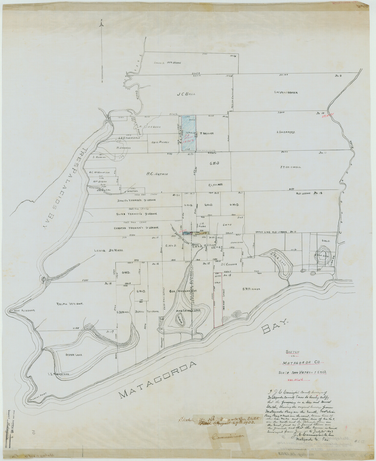
Matagorda County Rolled Sketch 9
Sketch in Matagorda Co.
-
Map/Doc
6680
-
Collection
General Map Collection
-
Object Dates
1903/7/20 (Survey Date)
1903/8/29 (File Date)
-
People and Organizations
J.C. Carrington (Surveyor/Engineer)
-
Counties
Matagorda
-
Subjects
Surveying Rolled Sketch
-
Height x Width
36.8 x 30.0 inches
93.5 x 76.2 cm
-
Medium
linen, manuscript
-
Scale
1" = 1000 varas
Part of: General Map Collection
Val Verde County Working Sketch 93

Print $20.00
- Digital $50.00
Val Verde County Working Sketch 93
1976
Size 40.9 x 40.6 inches
Map/Doc 72228
Topographical Map of the Rio Grande, Sheet No. 22

Print $20.00
- Digital $50.00
Topographical Map of the Rio Grande, Sheet No. 22
1912
Map/Doc 89546
Morris County Rolled Sketch 2A

Print $20.00
- Digital $50.00
Morris County Rolled Sketch 2A
Size 24.0 x 18.8 inches
Map/Doc 10274
Harrison County Working Sketch 6

Print $20.00
- Digital $50.00
Harrison County Working Sketch 6
1954
Size 27.6 x 38.7 inches
Map/Doc 66026
Shelby County Sketch File 32

Print $20.00
- Digital $50.00
Shelby County Sketch File 32
1949
Size 23.4 x 17.7 inches
Map/Doc 12321
Dallas County Working Sketch Graphic Index

Print $20.00
- Digital $50.00
Dallas County Working Sketch Graphic Index
1942
Size 43.9 x 36.7 inches
Map/Doc 76517
Cochran County Sketch File 3

Print $4.00
- Digital $50.00
Cochran County Sketch File 3
Size 8.8 x 11.3 inches
Map/Doc 18540
Flight Mission No. DQN-2K, Frame 3, Calhoun County

Print $20.00
- Digital $50.00
Flight Mission No. DQN-2K, Frame 3, Calhoun County
1953
Size 18.8 x 22.4 inches
Map/Doc 84220
Tyler County Sketch File 16

Print $6.00
- Digital $50.00
Tyler County Sketch File 16
1860
Size 9.4 x 11.8 inches
Map/Doc 38661
Presidio County Sketch File 121

Print $57.00
- Digital $50.00
Presidio County Sketch File 121
1998
Size 11.0 x 8.5 inches
Map/Doc 82620
[Right of Way Map, Belton Branch of the M.K.&T. RR.]
![64221, [Right of Way Map, Belton Branch of the M.K.&T. RR.], General Map Collection](https://historictexasmaps.com/wmedia_w700/maps/64221.tif.jpg)
Print $20.00
- Digital $50.00
[Right of Way Map, Belton Branch of the M.K.&T. RR.]
1896
Size 22.0 x 7.1 inches
Map/Doc 64221
Milam County Boundary File 5b

Print $20.00
- Digital $50.00
Milam County Boundary File 5b
Size 22.6 x 37.8 inches
Map/Doc 57239
You may also like
[John S. Stephens Blk. S-2, J. A. Oden Blk. 1, Lgs. 174-176]
![90247, [John S. Stephens Blk. S-2, J. A. Oden Blk. 1, Lgs. 174-176], Twichell Survey Records](https://historictexasmaps.com/wmedia_w700/maps/90247-1.tif.jpg)
Print $20.00
- Digital $50.00
[John S. Stephens Blk. S-2, J. A. Oden Blk. 1, Lgs. 174-176]
1913
Size 24.8 x 31.5 inches
Map/Doc 90247
Presidio County Rolled Sketch 13

Print $40.00
- Digital $50.00
Presidio County Rolled Sketch 13
1882
Size 58.8 x 48.0 inches
Map/Doc 9763
Map of Gray County

Print $20.00
- Digital $50.00
Map of Gray County
1900
Size 43.4 x 40.5 inches
Map/Doc 95511
Kinney County Rolled Sketch 8

Print $20.00
- Digital $50.00
Kinney County Rolled Sketch 8
Size 28.0 x 43.9 inches
Map/Doc 6537
La Salle County Rolled Sketch 6A

Print $40.00
- Digital $50.00
La Salle County Rolled Sketch 6A
1941
Size 43.5 x 68.2 inches
Map/Doc 10729
Lampasas County Sketch File 1

Print $4.00
- Digital $50.00
Lampasas County Sketch File 1
Size 12.6 x 8.1 inches
Map/Doc 29388
Wilson County Working Sketch 11

Print $20.00
- Digital $50.00
Wilson County Working Sketch 11
1980
Size 14.4 x 13.1 inches
Map/Doc 72591
Calhoun County Working Sketch 3

Print $20.00
- Digital $50.00
Calhoun County Working Sketch 3
1923
Size 18.4 x 42.4 inches
Map/Doc 67819
[Surveys in the vicinity of Archibald Smith's Survey and the Cyrena McReara Survey]
![92118, [Surveys in the vicinity of Archibald Smith's Survey and the Cyrena McReara Survey], Twichell Survey Records](https://historictexasmaps.com/wmedia_w700/maps/92118-1.tif.jpg)
Print $20.00
- Digital $50.00
[Surveys in the vicinity of Archibald Smith's Survey and the Cyrena McReara Survey]
Size 27.8 x 32.5 inches
Map/Doc 92118
Montgomery County

Print $20.00
- Digital $50.00
Montgomery County
1871
Size 21.0 x 24.6 inches
Map/Doc 3891
Upton County Sketch File 28

Print $5.00
- Digital $50.00
Upton County Sketch File 28
1929
Size 22.8 x 31.8 inches
Map/Doc 12521
Crane County Rolled Sketch 5

Print $20.00
- Digital $50.00
Crane County Rolled Sketch 5
1927
Size 38.4 x 45.7 inches
Map/Doc 8677