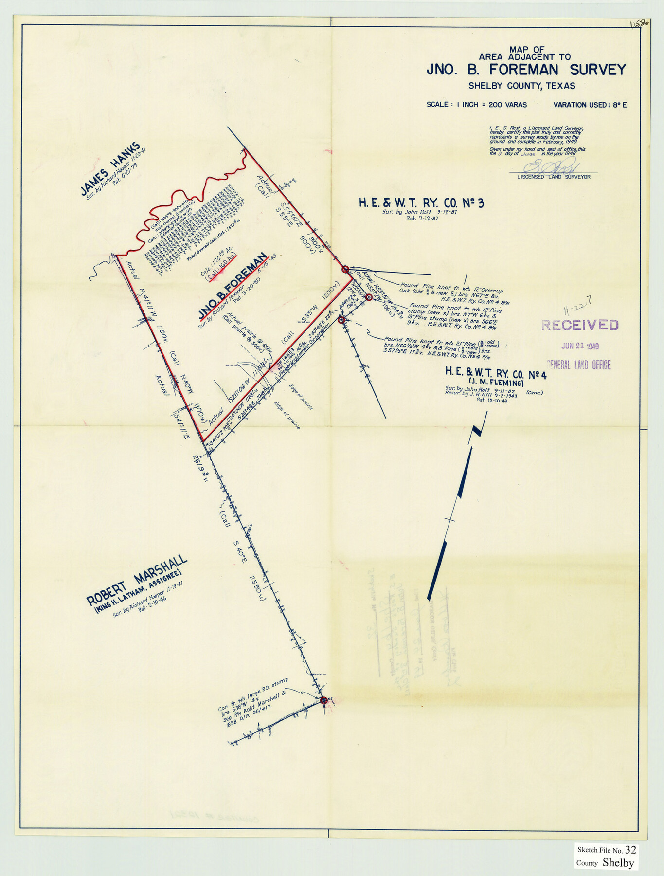
Shelby County Sketch File 32
Map of Area Adjacent to Jno. B. Foreman Survey, Shelby County, Texas
-
Map/Doc
12321
-
Collection
General Map Collection
-
Object Dates
6/3/1949 (Creation Date)
6/24/1949 (File Date)
-
People and Organizations
E.S. Rest (Surveyor/Engineer)
-
Counties
Shelby
-
Subjects
Surveying Sketch File
-
Height x Width
23.4 x 17.7 inches
59.4 x 45.0 cm
-
Medium
blueprint/diazo
-
Scale
1" = 200 varas
-
Comments
For accompanying surveyor's report see Shelby County Sketch File 33 (36670).
Note that the year pre-printed on the sketch is 1948 but based upon the accompanying report date, the received date, and the file date, the year should be 1949.
Related maps
Shelby County Sketch File 33

Print $8.00
- Digital $50.00
Shelby County Sketch File 33
1949
Size 11.5 x 9.0 inches
Map/Doc 36670
Part of: General Map Collection
[Right of Way & Track Map, The Texas & Pacific Ry. Co. Main Line]
![64678, [Right of Way & Track Map, The Texas & Pacific Ry. Co. Main Line], General Map Collection](https://historictexasmaps.com/wmedia_w700/maps/64678.tif.jpg)
Print $20.00
- Digital $50.00
[Right of Way & Track Map, The Texas & Pacific Ry. Co. Main Line]
Size 11.1 x 18.3 inches
Map/Doc 64678
Flight Mission No. CUG-2P, Frame 69, Kleberg County

Print $20.00
- Digital $50.00
Flight Mission No. CUG-2P, Frame 69, Kleberg County
1956
Size 18.4 x 22.2 inches
Map/Doc 86206
Harris County Boundary File 40

Print $8.00
- Digital $50.00
Harris County Boundary File 40
Size 14.2 x 8.7 inches
Map/Doc 54370
Leon County Rolled Sketch 33

Print $20.00
- Digital $50.00
Leon County Rolled Sketch 33
1997
Size 26.3 x 36.7 inches
Map/Doc 6617
Sutton County Rolled Sketch 52

Print $20.00
- Digital $50.00
Sutton County Rolled Sketch 52
1950
Size 20.8 x 35.2 inches
Map/Doc 7892
Culberson County Working Sketch 13

Print $20.00
- Digital $50.00
Culberson County Working Sketch 13
1922
Size 25.7 x 21.3 inches
Map/Doc 68465
Foard County Aerial Photograph Index Sheet 1

Print $20.00
- Digital $50.00
Foard County Aerial Photograph Index Sheet 1
1950
Size 19.2 x 17.2 inches
Map/Doc 83688
Hudspeth County Working Sketch 43

Print $40.00
- Digital $50.00
Hudspeth County Working Sketch 43
1981
Size 37.4 x 53.7 inches
Map/Doc 66328
Smith County Rolled Sketch 1

Print $20.00
- Digital $50.00
Smith County Rolled Sketch 1
Size 42.4 x 34.8 inches
Map/Doc 9932
Jefferson County Rolled Sketch 61D

Print $20.00
- Digital $50.00
Jefferson County Rolled Sketch 61D
Size 27.2 x 40.5 inches
Map/Doc 6413
Jeff Davis County Sketch File 20

Print $56.00
- Digital $50.00
Jeff Davis County Sketch File 20
1923
Size 11.2 x 8.8 inches
Map/Doc 27978
Liberty County Working Sketch 14

Print $20.00
- Digital $50.00
Liberty County Working Sketch 14
1919
Size 17.0 x 25.4 inches
Map/Doc 70473
You may also like
Atascosa County Rolled Sketch 17

Print $20.00
- Digital $50.00
Atascosa County Rolled Sketch 17
1953
Size 35.6 x 28.2 inches
Map/Doc 5097
Brewster County Rolled Sketch 53

Print $20.00
- Digital $50.00
Brewster County Rolled Sketch 53
1934
Size 43.8 x 37.6 inches
Map/Doc 8480
[Block 1 and vicinity]
![90703, [Block 1 and vicinity], Twichell Survey Records](https://historictexasmaps.com/wmedia_w700/maps/90703-1.tif.jpg)
Print $20.00
- Digital $50.00
[Block 1 and vicinity]
Size 25.3 x 24.1 inches
Map/Doc 90703
Nueces County Sketch File 61

Print $4.00
- Digital $50.00
Nueces County Sketch File 61
1930
Size 10.5 x 8.6 inches
Map/Doc 32969
Rusk County Sketch File 17a

Print $4.00
Rusk County Sketch File 17a
Size 8.4 x 7.8 inches
Map/Doc 35522
Hutchinson County Sketch File 35

Print $6.00
- Digital $50.00
Hutchinson County Sketch File 35
1935
Size 11.2 x 8.9 inches
Map/Doc 27267
Childress County Working Sketch 4

Print $20.00
- Digital $50.00
Childress County Working Sketch 4
1939
Size 43.4 x 14.5 inches
Map/Doc 68020
Flight Mission No. CLL-1N, Frame 105, Willacy County

Print $20.00
- Digital $50.00
Flight Mission No. CLL-1N, Frame 105, Willacy County
1954
Size 18.4 x 22.1 inches
Map/Doc 87039
Flight Mission No. CLL-1N, Frame 36, Willacy County

Print $20.00
- Digital $50.00
Flight Mission No. CLL-1N, Frame 36, Willacy County
1954
Size 18.3 x 22.1 inches
Map/Doc 87017
Hardeman County Sketch File 19

Print $6.00
- Digital $50.00
Hardeman County Sketch File 19
Size 14.3 x 8.8 inches
Map/Doc 25030
Gradient Boundary Survey of Canadian River through portions of Hutchinson & Roberts Counties, Texas

Print $40.00
- Digital $50.00
Gradient Boundary Survey of Canadian River through portions of Hutchinson & Roberts Counties, Texas
1989
Size 39.6 x 139.0 inches
Map/Doc 3120
Colorado County Sketch File 15

Print $4.00
- Digital $50.00
Colorado County Sketch File 15
Size 13.0 x 8.1 inches
Map/Doc 18943