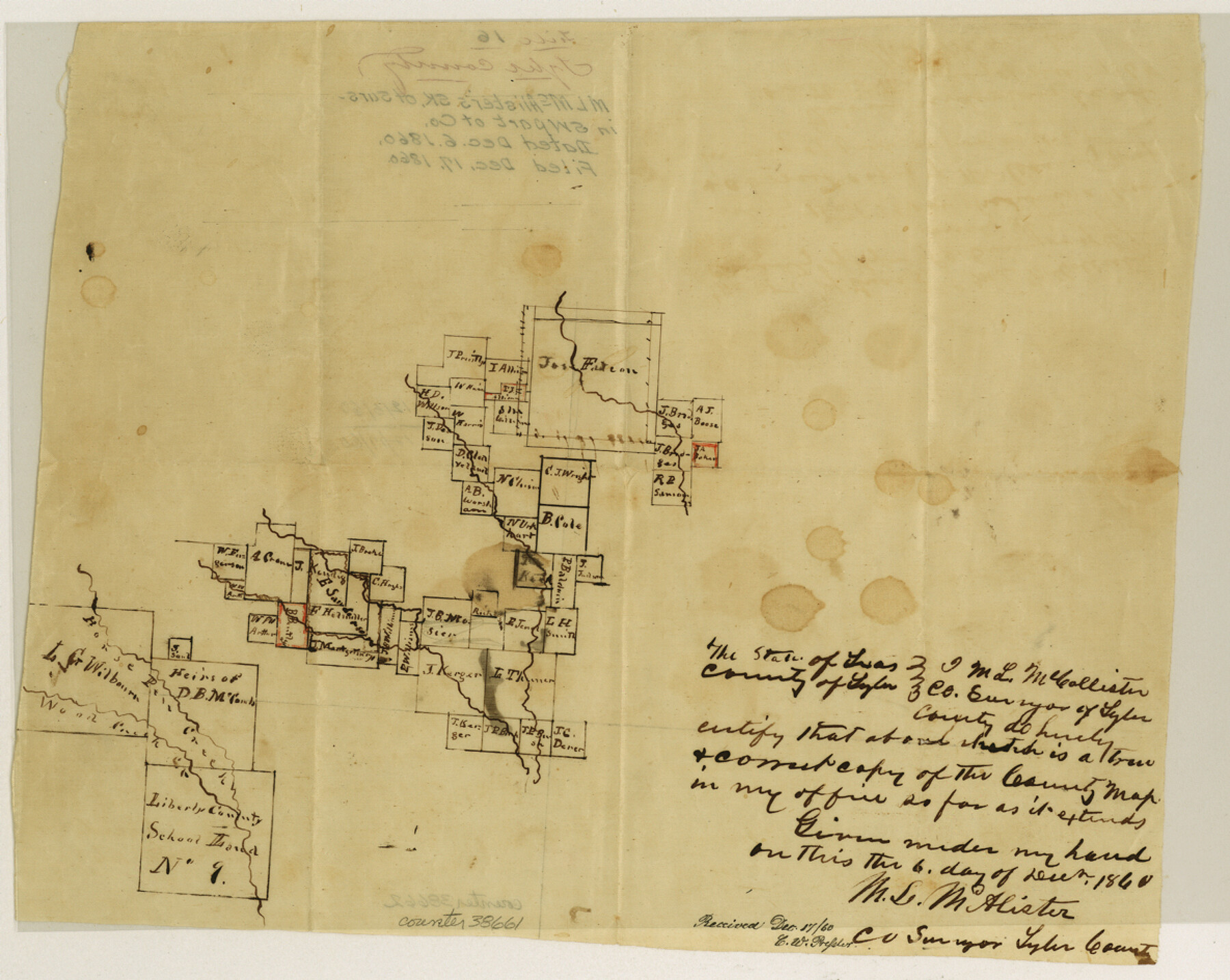
Tyler County Sketch File 16
[Sketch of surveys in the south part of the county]
-
Map/Doc
38661
-
Collection
General Map Collection
-
Object Dates
12/6/1860 (Creation Date)
12/17/1860 (File Date)
-
People and Organizations
M.L. McAlister (Surveyor/Engineer)
-
Counties
Tyler
-
Subjects
Surveying Sketch File
-
Height x Width
9.4 x 11.8 inches
23.9 x 30.0 cm
-
Medium
paper, manuscript
-
Features
Horse Pen Creek
Wood Creek
Part of: General Map Collection
Flight Mission No. CGI-3N, Frame 140, Cameron County

Print $20.00
- Digital $50.00
Flight Mission No. CGI-3N, Frame 140, Cameron County
1954
Size 18.8 x 22.5 inches
Map/Doc 84613
Current Miscellaneous File 68

Print $22.00
- Digital $50.00
Current Miscellaneous File 68
Size 11.2 x 8.8 inches
Map/Doc 74134
Webb County Working Sketch 87

Print $20.00
- Digital $50.00
Webb County Working Sketch 87
1981
Size 46.3 x 39.6 inches
Map/Doc 72454
Harris County Rolled Sketch 71

Print $20.00
- Digital $50.00
Harris County Rolled Sketch 71
1944
Size 19.3 x 26.7 inches
Map/Doc 6111
Brazos River, Brazos River Sheet 3

Print $20.00
- Digital $50.00
Brazos River, Brazos River Sheet 3
1926
Size 27.4 x 39.7 inches
Map/Doc 69667
Flight Mission No. CUG-1P, Frame 166, Kleberg County

Print $20.00
- Digital $50.00
Flight Mission No. CUG-1P, Frame 166, Kleberg County
1956
Size 18.8 x 22.4 inches
Map/Doc 86173
Panola County Working Sketch 29

Print $20.00
- Digital $50.00
Panola County Working Sketch 29
1980
Map/Doc 71438
Hardin County Sketch File 55

Print $40.00
- Digital $50.00
Hardin County Sketch File 55
1924
Size 14.2 x 13.3 inches
Map/Doc 25220
Maps of Gulf Intracoastal Waterway, Texas - Sabine River to the Rio Grande and connecting waterways including ship channels

Print $20.00
- Digital $50.00
Maps of Gulf Intracoastal Waterway, Texas - Sabine River to the Rio Grande and connecting waterways including ship channels
1966
Size 14.5 x 22.3 inches
Map/Doc 61936
Sketch of surveys in Harrison & Marion Cos. showing Caddo Lake & Subdivisions

Print $5.00
- Digital $50.00
Sketch of surveys in Harrison & Marion Cos. showing Caddo Lake & Subdivisions
1955
Size 32.6 x 32.5 inches
Map/Doc 2895
Blanco County Working Sketch 40

Print $20.00
- Digital $50.00
Blanco County Working Sketch 40
1986
Size 28.3 x 24.5 inches
Map/Doc 67400
Culberson County Sketch File 14

Print $28.00
- Digital $50.00
Culberson County Sketch File 14
1928
Size 13.3 x 8.0 inches
Map/Doc 20176
You may also like
[County map showing Texas State Capitol Land and surrounding areas]
![93141, [County map showing Texas State Capitol Land and surrounding areas], Twichell Survey Records](https://historictexasmaps.com/wmedia_w700/maps/93141-1.tif.jpg)
Print $40.00
- Digital $50.00
[County map showing Texas State Capitol Land and surrounding areas]
Size 51.5 x 66.7 inches
Map/Doc 93141
[Sketch highlighting Bob Reid and Fred Turner surveys]
![91693, [Sketch highlighting Bob Reid and Fred Turner surveys], Twichell Survey Records](https://historictexasmaps.com/wmedia_w700/maps/91693-1.tif.jpg)
Print $20.00
- Digital $50.00
[Sketch highlighting Bob Reid and Fred Turner surveys]
Size 12.5 x 17.8 inches
Map/Doc 91693
Jefferson County Rolled Sketch 64

Print $20.00
- Digital $50.00
Jefferson County Rolled Sketch 64
1982
Size 26.7 x 37.4 inches
Map/Doc 9319
Williamson County

Print $40.00
- Digital $50.00
Williamson County
1946
Size 38.7 x 56.8 inches
Map/Doc 95676
Hale County Boundary File 9

Print $68.00
- Digital $50.00
Hale County Boundary File 9
Size 14.2 x 8.8 inches
Map/Doc 54111
Hardin County Sketch File 64

Print $24.00
- Digital $50.00
Hardin County Sketch File 64
1936
Size 24.5 x 25.6 inches
Map/Doc 11638
Panola County Working Sketch 18

Print $20.00
- Digital $50.00
Panola County Working Sketch 18
1945
Map/Doc 71427
Live Oak County Working Sketch 17

Print $20.00
- Digital $50.00
Live Oak County Working Sketch 17
1960
Size 29.5 x 26.9 inches
Map/Doc 70602
Trinity County Working Sketch 16

Print $20.00
- Digital $50.00
Trinity County Working Sketch 16
1978
Size 31.7 x 41.2 inches
Map/Doc 69465
General Highway Map, Hidalgo County, Texas

Print $20.00
General Highway Map, Hidalgo County, Texas
1940
Size 18.4 x 25.0 inches
Map/Doc 79128
Wichita County Working Sketch 25

Print $20.00
- Digital $50.00
Wichita County Working Sketch 25
1980
Size 27.1 x 27.7 inches
Map/Doc 72535
Mexico, Texas und Californien

Print $20.00
- Digital $50.00
Mexico, Texas und Californien
1855
Size 22.7 x 28.0 inches
Map/Doc 93651