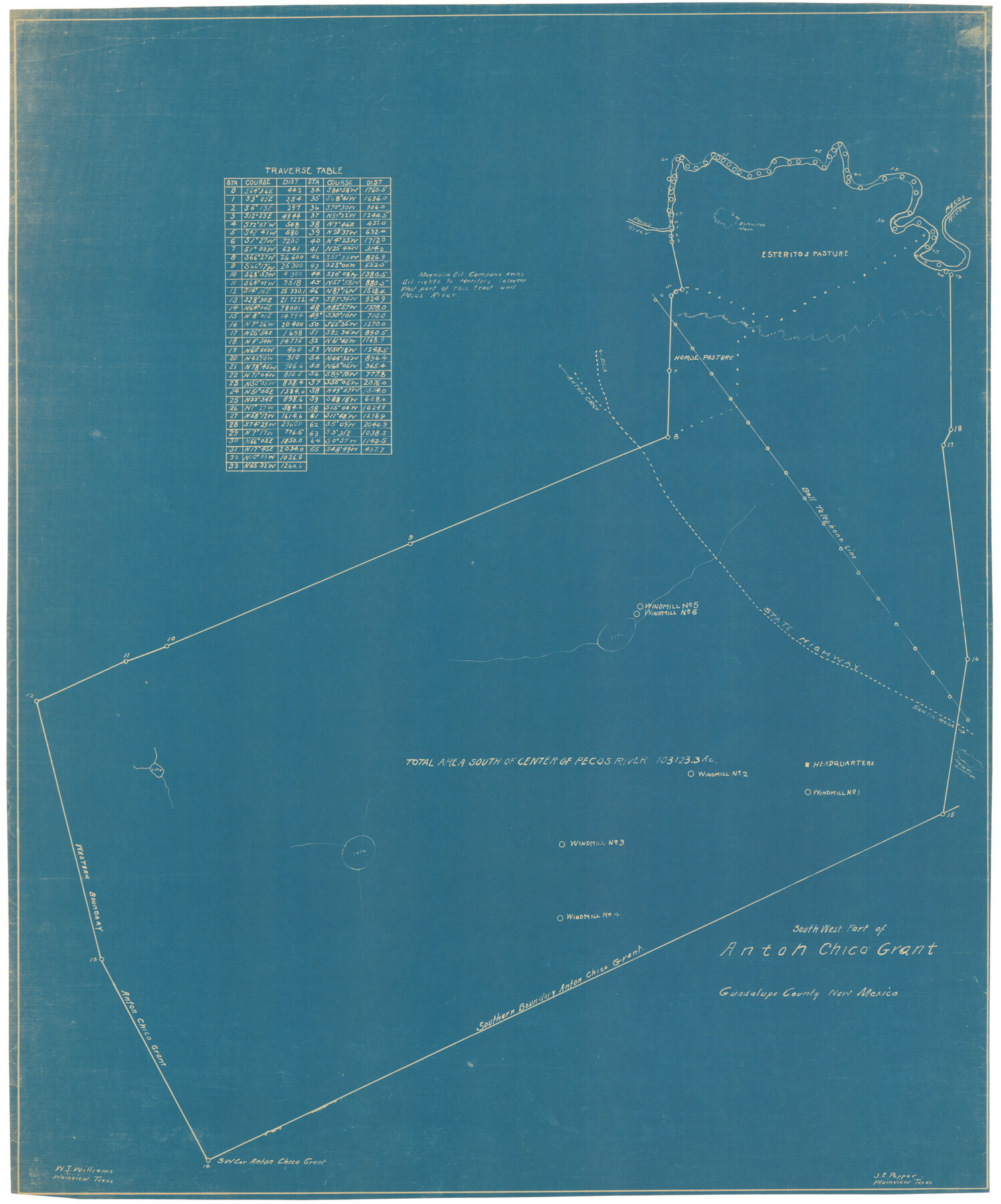
Southwest Part of Anton Chico Grant Guadalupe County, New Mexico
- 
                          Map/Doc92435
- 
                            CollectionTwichell Survey Records
- 
                            People and OrganizationsJ.E. Pepper (Surveyor/Engineer)W.J. Williams (Surveyor/Engineer)
- 
                            CountiesGuadalupe
- 
                            Height x Width23.8 x 28.6 inches60.5 x 72.6 cm
Part of: Twichell Survey Records
            C. A. Pierce's Subdivision of Dick Slaughter Land


                                            Print $20.00                    
                                             -                         Digital $50.00                                    
                C. A. Pierce's Subdivision of Dick Slaughter Land
1924
Size 19.0 x 8.6 inches
                                Map/Doc 90290
            
            [Subdivision Plat of 80 acres]
            
                                    ![93074, [Subdivision Plat of 80 acres], Twichell Survey Records](https://historictexasmaps.com/wmedia_w700/maps/93074-1.tif.jpg) 


    ![93074, [Subdivision Plat of 80 acres], Twichell Survey Records](https://historictexasmaps.com/wmedia_w700/maps/93074-1.tif.jpg) 
                                
            
                                            Print $2.00                    
                                             -                         Digital $50.00                                    
                [Subdivision Plat of 80 acres]
Size 10.6 x 6.3 inches
                                Map/Doc 93074
            
            Wheelock's Second Addit(ion)


                                            Print $20.00                    
                                             -                         Digital $50.00                                    
                Wheelock's Second Addit(ion)
Size 31.5 x 32.3 inches
                                Map/Doc 92820
            
            Val Verde County, Texas, E. L. & R. R. Ry. Block D7 showing beginning point and direction of certain surveys


                                            Print $20.00                    
                                             -                         Digital $50.00                                    
                Val Verde County, Texas, E. L. & R. R. Ry. Block D7 showing beginning point and direction of certain surveys
1937
Size 22.1 x 17.0 inches
                                Map/Doc 91950
            
            [Sketch showing B. S. & F. Block 9]
            
                                    ![91743, [Sketch showing B. S. & F. Block 9], Twichell Survey Records](https://historictexasmaps.com/wmedia_w700/maps/91743-1.tif.jpg) 


    ![91743, [Sketch showing B. S. & F. Block 9], Twichell Survey Records](https://historictexasmaps.com/wmedia_w700/maps/91743-1.tif.jpg) 
                                
            
                                            Print $20.00                    
                                             -                         Digital $50.00                                    
                [Sketch showing B. S. & F. Block 9]
Size 25.1 x 34.1 inches
                                Map/Doc 91743
            
            W. L. Ellwood's O Ranch, Lubbock and Hockley Co.


                                            Print $20.00                    
                                             -                         Digital $50.00                                    
                W. L. Ellwood's O Ranch, Lubbock and Hockley Co.
Size 15.5 x 23.8 inches
                                Map/Doc 92762
            
            Official Map of City of Lubbock


                                            Print $20.00                    
                                             -                         Digital $50.00                                    
                Official Map of City of Lubbock
1927
Size 29.3 x 22.7 inches
                                Map/Doc 92717
            
            Sketch in Lynn, Terry, Gaines and Dawson Counties


                                            Print $40.00                    
                                             -                         Digital $50.00                                    
                Sketch in Lynn, Terry, Gaines and Dawson Counties
1940
Size 53.2 x 33.1 inches
                                Map/Doc 92060
            
            [Block 6T, Portions of Blocks 44, 2T, and 3T, and vicinity]
            
                                    ![91526, [Block 6T, Portions of Blocks 44, 2T, and 3T, and vicinity], Twichell Survey Records](https://historictexasmaps.com/wmedia_w700/maps/91526-1.tif.jpg) 


    ![91526, [Block 6T, Portions of Blocks 44, 2T, and 3T, and vicinity], Twichell Survey Records](https://historictexasmaps.com/wmedia_w700/maps/91526-1.tif.jpg) 
                                
            
                                            Print $20.00                    
                                             -                         Digital $50.00                                    
                [Block 6T, Portions of Blocks 44, 2T, and 3T, and vicinity]
Size 14.2 x 15.9 inches
                                Map/Doc 91526
            
            [Capitol Leagues 225-238]
            
                                    ![90677, [Capitol Leagues 225-238], Twichell Survey Records](https://historictexasmaps.com/wmedia_w700/maps/90677-1.tif.jpg) 


    ![90677, [Capitol Leagues 225-238], Twichell Survey Records](https://historictexasmaps.com/wmedia_w700/maps/90677-1.tif.jpg) 
                                
            
                                            Print $20.00                    
                                             -                         Digital $50.00                                    
                [Capitol Leagues 225-238]
Size 23.2 x 13.0 inches
                                Map/Doc 90677
            
            Capitol Lands survey by J. T. Munson


                                            Print $20.00                    
                                             -                         Digital $50.00                                    
                Capitol Lands survey by J. T. Munson
Size 25.6 x 21.0 inches
                                Map/Doc 90575
            You may also like
            Navigation Maps of Gulf Intracoastal Waterway, Port Arthur to Brownsville, Texas


                                            Print $4.00                    
                                             -                         Digital $50.00                                    
                Navigation Maps of Gulf Intracoastal Waterway, Port Arthur to Brownsville, Texas
1951
Size 16.8 x 21.6 inches
                                Map/Doc 65419
            
            Childress County Rolled Sketch 9C


                                            Print $20.00                    
                                             -                         Digital $50.00                                    
                Childress County Rolled Sketch 9C
Size 13.8 x 17.9 inches
                                Map/Doc 5449
            
            Map of part of the Southern States to illustrate Olney's school geography


                                            Print $20.00                    
                                             -                         Digital $50.00                                    
                Map of part of the Southern States to illustrate Olney's school geography
1844
Size 12.1 x 19.0 inches
                                Map/Doc 93540
            
            Capitol Grounds, Austin


                                            Print $20.00                    
                                             -                         Digital $50.00                                    
                Capitol Grounds, Austin
Size 35.4 x 40.5 inches
                                Map/Doc 16955
            
            Marion County Working Sketch 40


                                            Print $20.00                    
                                             -                         Digital $50.00                                    
                Marion County Working Sketch 40
1992
Size 42.9 x 30.0 inches
                                Map/Doc 70816
            
            Starr County Sketch File 30A


                                            Print $20.00                    
                                             -                         Digital $50.00                                    
                Starr County Sketch File 30A
1935
Size 21.2 x 23.6 inches
                                Map/Doc 12334
            
            [Right of Way & Track Map, The Texas & Pacific Ry. Co. Main Line]
            
                                    ![64666, [Right of Way & Track Map, The Texas & Pacific Ry. Co. Main Line], General Map Collection](https://historictexasmaps.com/wmedia_w700/maps/64666.tif.jpg) 


    ![64666, [Right of Way & Track Map, The Texas & Pacific Ry. Co. Main Line], General Map Collection](https://historictexasmaps.com/wmedia_w700/maps/64666.tif.jpg) 
                                
            
                                            Print $20.00                    
                                             -                         Digital $50.00                                    
                [Right of Way & Track Map, The Texas & Pacific Ry. Co. Main Line]
Size 11.0 x 18.5 inches
                                Map/Doc 64666
            
            Karnes County Sketch File 14


                                            Print $6.00                    
                                             -                         Digital $50.00                                    
                Karnes County Sketch File 14
1897
Size 9.7 x 6.2 inches
                                Map/Doc 28615
            
            Uvalde County Working Sketch 55


                                            Print $20.00                    
                                             -                         Digital $50.00                                    
                Uvalde County Working Sketch 55
1983
Size 38.9 x 37.6 inches
                                Map/Doc 72125
            
            Stephens County Sketch File 25


                                            Print $35.00                    
                                             -                         Digital $50.00                                    
                Stephens County Sketch File 25
1875
Size 11.0 x 15.9 inches
                                Map/Doc 37090
            
            Flight Mission No. DAG-21K, Frame 99, Matagorda County


                                            Print $20.00                    
                                             -                         Digital $50.00                                    
                Flight Mission No. DAG-21K, Frame 99, Matagorda County
1952
Size 17.5 x 16.3 inches
                                Map/Doc 86428
            
            The Mexican Department of Nacogdoches. May 6, 1833


                                            Print $20.00                    
                                    
                The Mexican Department of Nacogdoches. May 6, 1833
2020
Size 18.5 x 21.7 inches
                                Map/Doc 95973
             
                        