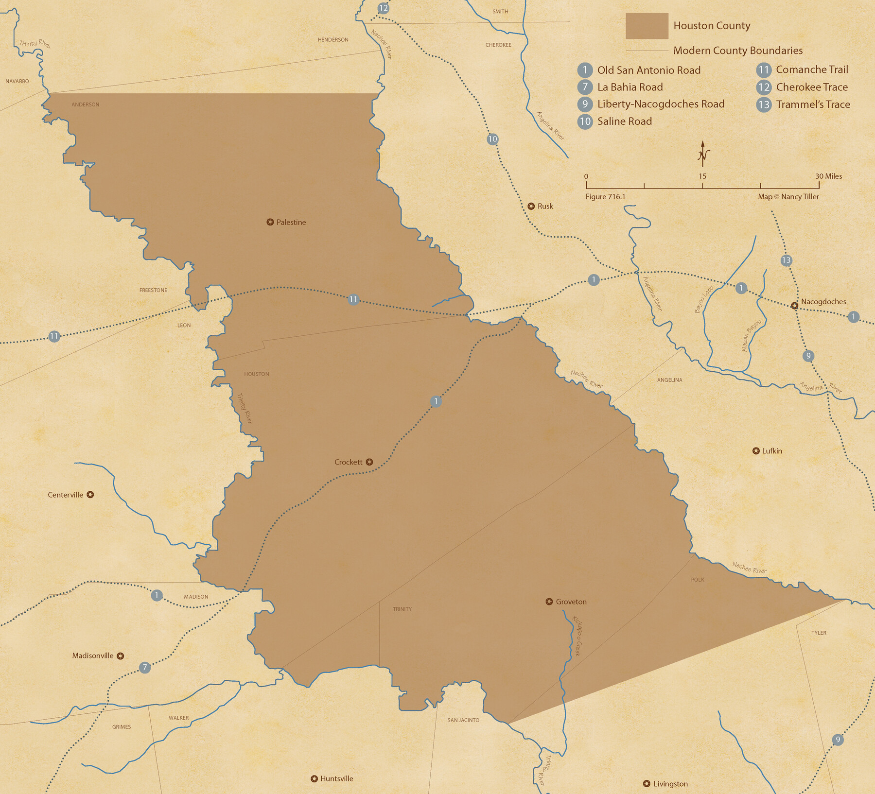
The Republic County of Houston. Created, June 12, 1837
Figure No. 716.1 from 'A Boundary Atlas of Texas, 1821-1845' by Jim Tiller
-
Map/Doc
96178
-
Collection
Nancy and Jim Tiller Digital Collection
-
Object Dates
2020/1/1 (Creation Date)
-
People and Organizations
Jim Tiller (Author)
Nancy Tiller (Cartographer)
Gang Gong (GIS Professional)
-
Counties
Houston
-
Subjects
Atlas County Republic of Texas Texas Boundaries
-
Height x Width
19.7 x 21.7 inches
50.0 x 55.1 cm
-
Medium
digital image
-
Comments
To purchase a digital PDF copy of "A Boundary Atlas of Texas, 1821-1845" see 96437.
Part of: Nancy and Jim Tiller Digital Collection
Thorn Empresario Colony. April 25, 1825

Print $20.00
Thorn Empresario Colony. April 25, 1825
2020
Size 17.0 x 21.7 inches
Map/Doc 96006
The Coastal and Border League Lines

Print $20.00
The Coastal and Border League Lines
2020
Size 20.2 x 21.6 inches
Map/Doc 95977
The d’Orvane Colony. June 3, 1842

Print $20.00
The d’Orvane Colony. June 3, 1842
2020
Size 13.1 x 21.7 inches
Map/Doc 96369
From Citizens of Colorado and Matagorda Counties for the Creation of a New County (Unnamed), August 6, 1840

Print $20.00
From Citizens of Colorado and Matagorda Counties for the Creation of a New County (Unnamed), August 6, 1840
2020
Size 18.5 x 21.7 inches
Map/Doc 96389
The Republic County of Bowie. Spring 1842

Print $20.00
The Republic County of Bowie. Spring 1842
2020
Size 19.5 x 21.7 inches
Map/Doc 96105
The Judicial District/County of Pashcal. Abolished, Spring 1842

Print $20.00
The Judicial District/County of Pashcal. Abolished, Spring 1842
2020
Size 15.0 x 21.7 inches
Map/Doc 96345
The Republic County of Gonzales. May 24, 1838

Print $20.00
The Republic County of Gonzales. May 24, 1838
2020
Size 14.7 x 21.7 inches
Map/Doc 96156
The Peters Colony. November 9, 1841

Print $20.00
The Peters Colony. November 9, 1841
2020
Size 21.7 x 21.7 inches
Map/Doc 96363
The Republic County of Washington. February 4, 1840

Print $20.00
The Republic County of Washington. February 4, 1840
2020
Size 20.3 x 21.7 inches
Map/Doc 96304
The Mexican Municipality of Harrisburg. Defined, January 4, 1836

Print $20.00
The Mexican Municipality of Harrisburg. Defined, January 4, 1836
2020
Size 18.4 x 21.7 inches
Map/Doc 96022
The Republic County of Harris. December 31, 1838

Print $20.00
The Republic County of Harris. December 31, 1838
2020
Size 17.7 x 21.7 inches
Map/Doc 96164
The Republic County of Fayette. January 29, 1842

Print $20.00
The Republic County of Fayette. January 29, 1842
2020
Size 14.7 x 21.7 inches
Map/Doc 96134
You may also like
Oldham County Rolled Sketch 7

Print $20.00
- Digital $50.00
Oldham County Rolled Sketch 7
Size 36.2 x 27.5 inches
Map/Doc 7173
Kerr County Working Sketch 21

Print $40.00
- Digital $50.00
Kerr County Working Sketch 21
1960
Size 24.4 x 54.5 inches
Map/Doc 70052
Brewster County Working Sketch 71b

Print $40.00
- Digital $50.00
Brewster County Working Sketch 71b
1961
Size 50.6 x 55.0 inches
Map/Doc 67870
Hudspeth County Working Sketch 44

Print $20.00
- Digital $50.00
Hudspeth County Working Sketch 44
1982
Size 25.5 x 22.2 inches
Map/Doc 66329
Lipscomb County Rolled Sketch 5

Print $40.00
- Digital $50.00
Lipscomb County Rolled Sketch 5
Size 61.8 x 8.1 inches
Map/Doc 10640
Coast Chart No. 210 Aransas Pass and Corpus Christi Bay with the coast to latitude 27° 12' Texas

Print $20.00
- Digital $50.00
Coast Chart No. 210 Aransas Pass and Corpus Christi Bay with the coast to latitude 27° 12' Texas
1887
Size 27.3 x 18.3 inches
Map/Doc 72803
Borden County Boundary File 3

Print $62.00
- Digital $50.00
Borden County Boundary File 3
1908
Size 28.7 x 82.9 inches
Map/Doc 1695
[Sketch showing A. B. & M. Block 2]
![91701, [Sketch showing A. B. & M. Block 2], Twichell Survey Records](https://historictexasmaps.com/wmedia_w700/maps/91701-1.tif.jpg)
Print $2.00
- Digital $50.00
[Sketch showing A. B. & M. Block 2]
Size 7.5 x 5.8 inches
Map/Doc 91701
[Surveying Sketch of Martha G. Morrow, Mary Bigger, et al in Travis County]
![522, [Surveying Sketch of Martha G. Morrow, Mary Bigger, et al in Travis County], Maddox Collection](https://historictexasmaps.com/wmedia_w700/maps/522.tif.jpg)
Print $3.00
- Digital $50.00
[Surveying Sketch of Martha G. Morrow, Mary Bigger, et al in Travis County]
Size 12.4 x 9.6 inches
Map/Doc 522
Atascosa County Rolled Sketch 22

Print $40.00
- Digital $50.00
Atascosa County Rolled Sketch 22
1917
Size 26.1 x 57.2 inches
Map/Doc 8918
Kimble County Rolled Sketch 21

Print $20.00
- Digital $50.00
Kimble County Rolled Sketch 21
Size 10.5 x 18.2 inches
Map/Doc 6512
[John Welch, W. F. Butter, and surrounding surveys]
![91011, [John Welch, W. F. Butter, and surrounding surveys], Twichell Survey Records](https://historictexasmaps.com/wmedia_w700/maps/91011-1.tif.jpg)
Print $3.00
- Digital $50.00
[John Welch, W. F. Butter, and surrounding surveys]
Size 17.1 x 10.9 inches
Map/Doc 91011