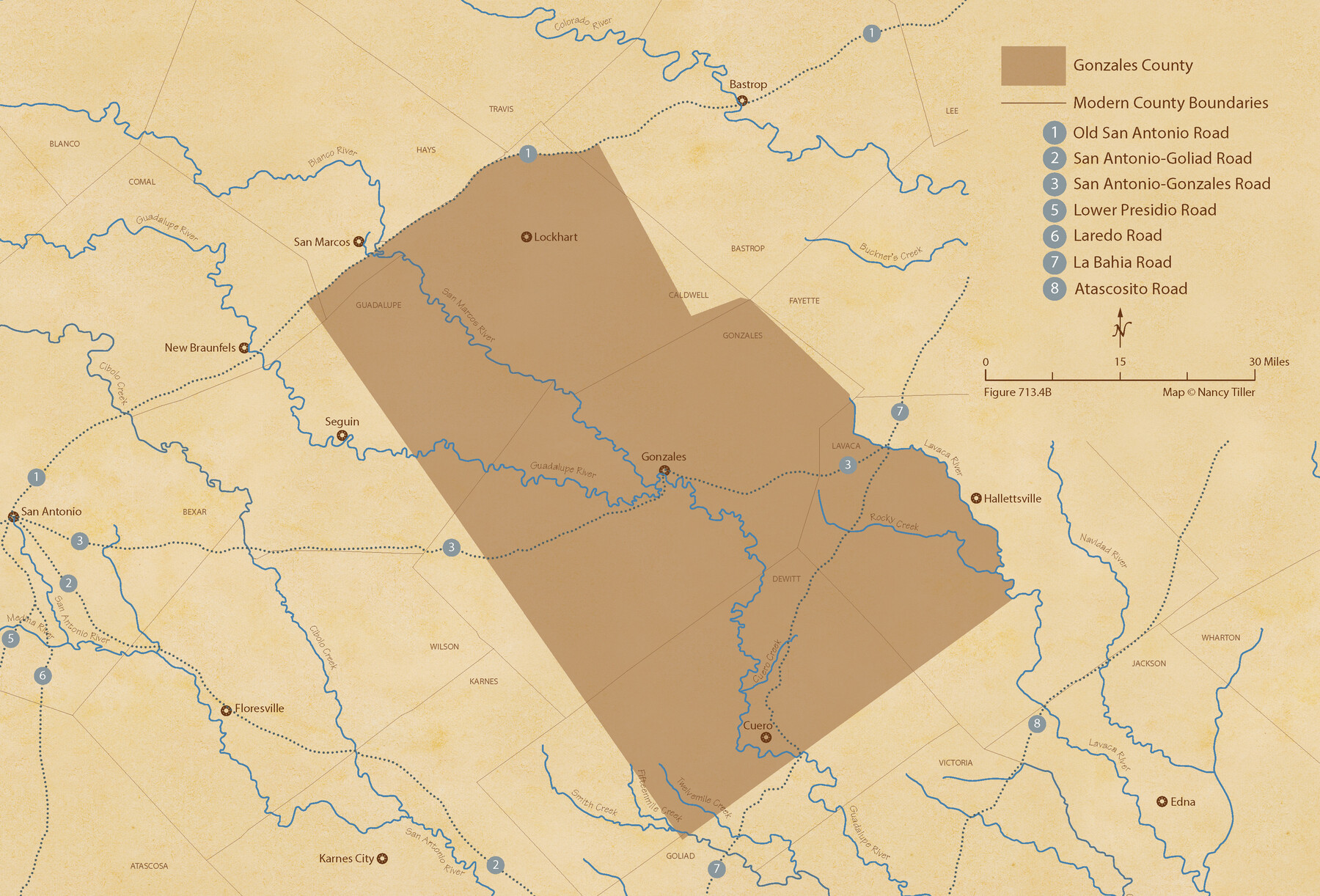
The Republic County of Gonzales. May 24, 1838
Figure No. 713.4 from 'A Boundary Atlas of Texas, 1821-1845' by Jim Tiller
-
Map/Doc
96156
-
Collection
Nancy and Jim Tiller Digital Collection
-
Object Dates
2020/1/1 (Creation Date)
-
People and Organizations
Jim Tiller (Author)
Nancy Tiller (Cartographer)
Gang Gong (GIS Professional)
-
Counties
Gonzales
-
Subjects
Atlas County Republic of Texas Texas Boundaries
-
Height x Width
14.7 x 21.7 inches
37.3 x 55.1 cm
-
Medium
digital image
-
Comments
To purchase a digital PDF copy of "A Boundary Atlas of Texas, 1821-1845" see 96437.
Part of: Nancy and Jim Tiller Digital Collection
Filisola Empresario Colony. October 15, 1831

Print $20.00
Filisola Empresario Colony. October 15, 1831
2020
Size 15.3 x 21.7 inches
Map/Doc 95995
The Republic County of Gonzales. Boundaries Defined, December 14, 1837

Print $20.00
The Republic County of Gonzales. Boundaries Defined, December 14, 1837
2020
Size 14.7 x 21.7 inches
Map/Doc 96153
The Republic County of Bexar. November 28, 1839

Print $20.00
The Republic County of Bexar. November 28, 1839
2020
Size 14.8 x 21.1 inches
Map/Doc 96097
McMullen and McGloin Empresario Colony. August 16, 1828

Print $20.00
McMullen and McGloin Empresario Colony. August 16, 1828
2020
Size 17.6 x 21.7 inches
Map/Doc 95998
The Mexican Department of Bexar. On the Eve of Texas Independence, 1836

Print $20.00
The Mexican Department of Bexar. On the Eve of Texas Independence, 1836
2020
Size 16.0 x 21.7 inches
Map/Doc 95971
The Republic County of Fannin. December 29, 1845

Print $20.00
The Republic County of Fannin. December 29, 1845
2020
Size 12.9 x 21.7 inches
Map/Doc 96130
The Republic County of Fort Bend. Created, December 29, 1837

Print $20.00
The Republic County of Fort Bend. Created, December 29, 1837
2020
Size 14.7 x 21.6 inches
Map/Doc 96137
de Leon Empresario Colony. Absorbed by DeWitt Colony. April 15, 1825

Print $20.00
de Leon Empresario Colony. Absorbed by DeWitt Colony. April 15, 1825
2020
Size 18.5 x 21.7 inches
Map/Doc 95989
The Judicial District/County of Pashcal. Created, January 28, 1841

Print $20.00
The Judicial District/County of Pashcal. Created, January 28, 1841
2020
Size 15.0 x 21.7 inches
Map/Doc 96343
The Republic County of Brazoria. January 20, 1841

Print $20.00
The Republic County of Brazoria. January 20, 1841
2020
Size 14.7 x 21.8 inches
Map/Doc 96114
The Chief Justice County of Washington. Lands in Conflict with Nacogdoches County

Print $20.00
The Chief Justice County of Washington. Lands in Conflict with Nacogdoches County
2020
Size 13.0 x 21.7 inches
Map/Doc 96078
The Republic County of Goliad. Proposed, Late Fall 1837

Print $20.00
The Republic County of Goliad. Proposed, Late Fall 1837
2020
Size 15.1 x 21.7 inches
Map/Doc 96147
You may also like
Hopkins County Sketch File 4

Print $47.00
- Digital $50.00
Hopkins County Sketch File 4
Size 21.2 x 18.4 inches
Map/Doc 4565
[Sketch for Mineral Application 24072, San Jacinto River]
![65597, [Sketch for Mineral Application 24072, San Jacinto River], General Map Collection](https://historictexasmaps.com/wmedia_w700/maps/65597.tif.jpg)
Print $20.00
- Digital $50.00
[Sketch for Mineral Application 24072, San Jacinto River]
1929
Size 24.6 x 18.4 inches
Map/Doc 65597
Duval County Working Sketch 57

Print $20.00
- Digital $50.00
Duval County Working Sketch 57
1990
Size 30.3 x 25.4 inches
Map/Doc 68781
Gillespie County Working Sketch 8

Print $20.00
- Digital $50.00
Gillespie County Working Sketch 8
1993
Size 31.1 x 24.2 inches
Map/Doc 63171
Hemphill County Rolled Sketch 16

Print $40.00
- Digital $50.00
Hemphill County Rolled Sketch 16
1961
Size 65.4 x 26.9 inches
Map/Doc 9156
General Highway Map, Brewster County, Texas

Print $20.00
General Highway Map, Brewster County, Texas
1961
Size 18.3 x 24.9 inches
Map/Doc 79386
Hutchinson County Working Sketch 33

Print $20.00
- Digital $50.00
Hutchinson County Working Sketch 33
1978
Size 27.5 x 23.5 inches
Map/Doc 66393
The City of Austin and Suburbs

Print $40.00
- Digital $50.00
The City of Austin and Suburbs
1919
Size 120.7 x 73.5 inches
Map/Doc 2204
El Paso County Rolled Sketch 43A

Print $20.00
- Digital $50.00
El Paso County Rolled Sketch 43A
Size 23.2 x 22.6 inches
Map/Doc 5829
Flight Mission No. DAG-17K, Frame 61, Matagorda County

Print $20.00
- Digital $50.00
Flight Mission No. DAG-17K, Frame 61, Matagorda County
1952
Size 16.4 x 16.4 inches
Map/Doc 86323
Panola County Sketch File 26

Print $20.00
- Digital $50.00
Panola County Sketch File 26
1944
Size 28.5 x 27.1 inches
Map/Doc 12141
Map of Franklin County, Texas

Print $20.00
- Digital $50.00
Map of Franklin County, Texas
1879
Size 23.4 x 11.3 inches
Map/Doc 728