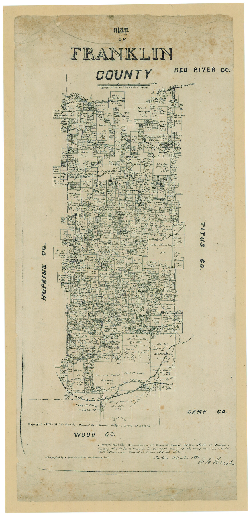
Map of Franklin County, Texas
-
Map/Doc
728
-
Collection
Maddox Collection
-
Object Dates
12/1879 (Creation Date)
1879 (Copyright Date)
-
People and Organizations
W.C. Walsh (GLO Commissioner)
August Gast & Co. (Lithographer)
-
Counties
Franklin
-
Subjects
County
-
Height x Width
23.4 x 11.3 inches
59.4 x 28.7 cm
-
Medium
paper, etching/engraving/lithograph
-
Scale
1" = 4000 varas
-
Comments
Adopted by First National Bank of Mount Vernon and conservation funded in 2005
-
Features
Bear Creek
EL&RR
Dry Cypress Creek
Glade Creek
Smith's Creek
Cedar Creek
Mountain Creek
Rather Creek
Andy's Creek
Sulphur Fork of Red River
Blundell's Creek
Ripley's Creek
Mt. Vernon
Timber Creek
Pecan Creek
Prairie Creek
Compass Creek
White Oak Br[anch]
Part of: Maddox Collection
[Sketch in Hutchinson County, Texas]
![76016, [Sketch in Hutchinson County, Texas], Maddox Collection](https://historictexasmaps.com/wmedia_w700/maps/76016.tif.jpg)
Print $20.00
- Digital $50.00
[Sketch in Hutchinson County, Texas]
Size 26.5 x 35.3 inches
Map/Doc 76016
Map of Concho County, Texas

Print $20.00
- Digital $50.00
Map of Concho County, Texas
1879
Size 28.8 x 23.9 inches
Map/Doc 703
[Sketch Showing Surveys north of South Canadian River, Hemphill County, Texas]
![10759, [Sketch Showing Surveys north of South Canadian River, Hemphill County, Texas], Maddox Collection](https://historictexasmaps.com/wmedia_w700/maps/10759-GC.tif.jpg)
Print $3.00
- Digital $50.00
[Sketch Showing Surveys north of South Canadian River, Hemphill County, Texas]
Size 9.8 x 14.9 inches
Map/Doc 10759
Motley County, Texas

Print $20.00
- Digital $50.00
Motley County, Texas
1883
Size 23.6 x 20.7 inches
Map/Doc 743
Map of Block No. "M1" made for the "School Fund" (32 Confederates)

Print $20.00
- Digital $50.00
Map of Block No. "M1" made for the "School Fund" (32 Confederates)
1882
Size 18.5 x 11.2 inches
Map/Doc 684
Sketch compiled from records of Collin County in General Land Office

Print $3.00
- Digital $50.00
Sketch compiled from records of Collin County in General Land Office
1878
Size 11.5 x 13.5 inches
Map/Doc 504
Sketch in NE Portion Hutchinson County

Print $20.00
- Digital $50.00
Sketch in NE Portion Hutchinson County
1913
Size 36.9 x 43.3 inches
Map/Doc 75815
[Surveying Sketch of Francisco Guerra, Antonio Ramirez, Diego Ynojosa, et al on Rio Grande, Starr County]
![5073, [Surveying Sketch of Francisco Guerra, Antonio Ramirez, Diego Ynojosa, et al on Rio Grande, Starr County], Maddox Collection](https://historictexasmaps.com/wmedia_w700/maps/5073-1.tif.jpg)
Print $20.00
- Digital $50.00
[Surveying Sketch of Francisco Guerra, Antonio Ramirez, Diego Ynojosa, et al on Rio Grande, Starr County]
1914
Size 21.7 x 13.0 inches
Map/Doc 5073
Delta County, Texas

Print $20.00
- Digital $50.00
Delta County, Texas
1884
Size 14.1 x 20.0 inches
Map/Doc 416
Map Showing Survey and Subdivision of the Wendlandt Property in Outlot 4, Division "Z"

Print $3.00
- Digital $50.00
Map Showing Survey and Subdivision of the Wendlandt Property in Outlot 4, Division "Z"
1910
Size 10.8 x 17.7 inches
Map/Doc 508
Callahan County, Texas

Print $20.00
- Digital $50.00
Callahan County, Texas
1880
Size 24.1 x 18.4 inches
Map/Doc 681
Map of Harrison County, Texas

Print $20.00
- Digital $50.00
Map of Harrison County, Texas
1879
Size 20.2 x 21.9 inches
Map/Doc 375
You may also like
[Maps of surveys in Reeves & Culberson Cos]
![61139, [Maps of surveys in Reeves & Culberson Cos], General Map Collection](https://historictexasmaps.com/wmedia_w700/maps/61139.tif.jpg)
Print $20.00
- Digital $50.00
[Maps of surveys in Reeves & Culberson Cos]
1937
Size 30.7 x 24.7 inches
Map/Doc 61139
Outer Continental Shelf Leasing Maps (Louisiana Offshore Operations)

Print $20.00
- Digital $50.00
Outer Continental Shelf Leasing Maps (Louisiana Offshore Operations)
1955
Size 16.2 x 13.0 inches
Map/Doc 76084
Gaines County Working Sketch 9

Print $40.00
- Digital $50.00
Gaines County Working Sketch 9
1951
Size 75.2 x 20.8 inches
Map/Doc 69309
Caldwell County Rolled Sketch 1

Print $20.00
- Digital $50.00
Caldwell County Rolled Sketch 1
1953
Size 20.2 x 30.4 inches
Map/Doc 10673
Map of Burnet Co.

Print $20.00
- Digital $50.00
Map of Burnet Co.
1887
Size 45.5 x 37.9 inches
Map/Doc 7816

Cameron County Sketch File 2

Print $98.00
- Digital $50.00
Cameron County Sketch File 2
1904
Size 14.3 x 8.7 inches
Map/Doc 16975

Val Verde County Working Sketch 32

Print $20.00
- Digital $50.00
Val Verde County Working Sketch 32
1938
Size 41.5 x 24.2 inches
Map/Doc 72167
Flight Mission No. DCL-6C, Frame 97, Kenedy County

Print $20.00
- Digital $50.00
Flight Mission No. DCL-6C, Frame 97, Kenedy County
1943
Size 18.6 x 22.3 inches
Map/Doc 85927
Crockett County Rolled Sketch 88G

Print $40.00
- Digital $50.00
Crockett County Rolled Sketch 88G
1973
Size 42.7 x 57.3 inches
Map/Doc 8732
Trinity County Rolled Sketch 2

Print $20.00
- Digital $50.00
Trinity County Rolled Sketch 2
1948
Size 34.5 x 34.9 inches
Map/Doc 10024