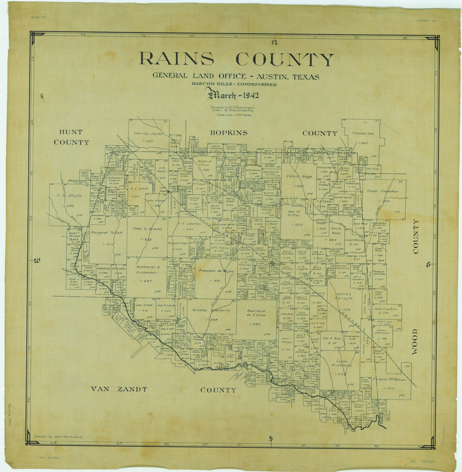
Rains County
-
Map/Doc
73337
-
Collection
General Map Collection
-
Object Dates
1942 (Creation Date)
-
People and Organizations
Texas General Land Office (Publisher)
Eltea Armstrong (Draftsman)
Bascom Giles (GLO Commissioner)
W. S. Brewington (Compiler)
-
Counties
Rains
-
Subjects
County
-
Height x Width
29.8 x 29.2 inches
75.7 x 74.2 cm
-
Comments
Traced by John Markward.
Part of: General Map Collection
Rio Grande Rectification Project, El Paso and Juarez Valley

Print $2.00
- Digital $50.00
Rio Grande Rectification Project, El Paso and Juarez Valley
1935
Size 10.8 x 8.2 inches
Map/Doc 60873
Webb County Working Sketch 26

Print $20.00
- Digital $50.00
Webb County Working Sketch 26
1931
Size 17.9 x 18.4 inches
Map/Doc 72391
Dimmit County Boundary File 7

Print $14.00
- Digital $50.00
Dimmit County Boundary File 7
Size 12.8 x 8.4 inches
Map/Doc 52590
Wise County Sketch File 23

Print $4.00
- Digital $50.00
Wise County Sketch File 23
1859
Size 7.9 x 12.9 inches
Map/Doc 40568
Nueces County Rolled Sketch 70

Print $60.00
Nueces County Rolled Sketch 70
1980
Size 25.3 x 38.0 inches
Map/Doc 6921
El Paso County Boundary File 2

Print $28.00
- Digital $50.00
El Paso County Boundary File 2
Size 13.2 x 8.2 inches
Map/Doc 53021
Medina County Rolled Sketch 17

Print $20.00
- Digital $50.00
Medina County Rolled Sketch 17
1979
Size 32.3 x 18.9 inches
Map/Doc 6750
Red River County Working Sketch 83

Print $20.00
- Digital $50.00
Red River County Working Sketch 83
1996
Size 21.0 x 22.3 inches
Map/Doc 72069
Map of Bexar County

Print $20.00
- Digital $50.00
Map of Bexar County
1845
Size 47.4 x 44.9 inches
Map/Doc 87234
Flight Mission No. CUG-2P, Frame 87, Kleberg County

Print $20.00
- Digital $50.00
Flight Mission No. CUG-2P, Frame 87, Kleberg County
1956
Size 18.4 x 22.2 inches
Map/Doc 86219
Controlled Mosaic by Jack Amman Photogrammetric Engineers, Inc - Sheet 41

Print $20.00
- Digital $50.00
Controlled Mosaic by Jack Amman Photogrammetric Engineers, Inc - Sheet 41
1954
Size 20.0 x 24.0 inches
Map/Doc 83496
Kendall County Working Sketch 25

Print $40.00
- Digital $50.00
Kendall County Working Sketch 25
1978
Size 39.4 x 56.8 inches
Map/Doc 66697
You may also like
Rand McNally Standard Map of Texas (reverse)

Print $20.00
Rand McNally Standard Map of Texas (reverse)
1923
Size 39.8 x 27.2 inches
Map/Doc 76229
Hutchinson County Rolled Sketch 42

Print $40.00
- Digital $50.00
Hutchinson County Rolled Sketch 42
1993
Size 38.0 x 49.5 inches
Map/Doc 6310
Camp County Working Sketch 1

Print $20.00
- Digital $50.00
Camp County Working Sketch 1
1970
Size 32.9 x 29.7 inches
Map/Doc 67877
Oldham County Boundary File 1b

Print $48.00
- Digital $50.00
Oldham County Boundary File 1b
Size 14.0 x 8.5 inches
Map/Doc 57747
Aransas County NRC Article 33.136 Sketch 1

Print $55.00
- Digital $50.00
Aransas County NRC Article 33.136 Sketch 1
2000
Size 24.8 x 35.6 inches
Map/Doc 61630

Ward County Rolled Sketch 4

Print $20.00
- Digital $50.00
Ward County Rolled Sketch 4
Size 39.3 x 47.2 inches
Map/Doc 10102
Crockett County Working Sketch 43

Print $20.00
- Digital $50.00
Crockett County Working Sketch 43
1931
Size 26.1 x 21.7 inches
Map/Doc 68376
G & H Blocks, Gaines County, Texas Resurvey

Print $40.00
- Digital $50.00
G & H Blocks, Gaines County, Texas Resurvey
1915
Size 58.1 x 33.7 inches
Map/Doc 89667
Webb County Working Sketch 81

Print $40.00
- Digital $50.00
Webb County Working Sketch 81
1979
Size 69.0 x 43.6 inches
Map/Doc 72448
Map of Mason County

Print $20.00
- Digital $50.00
Map of Mason County
1877
Size 25.3 x 19.9 inches
Map/Doc 3836
Motley County Working Sketch 11

Print $20.00
- Digital $50.00
Motley County Working Sketch 11
1989
Size 28.5 x 33.0 inches
Map/Doc 71216