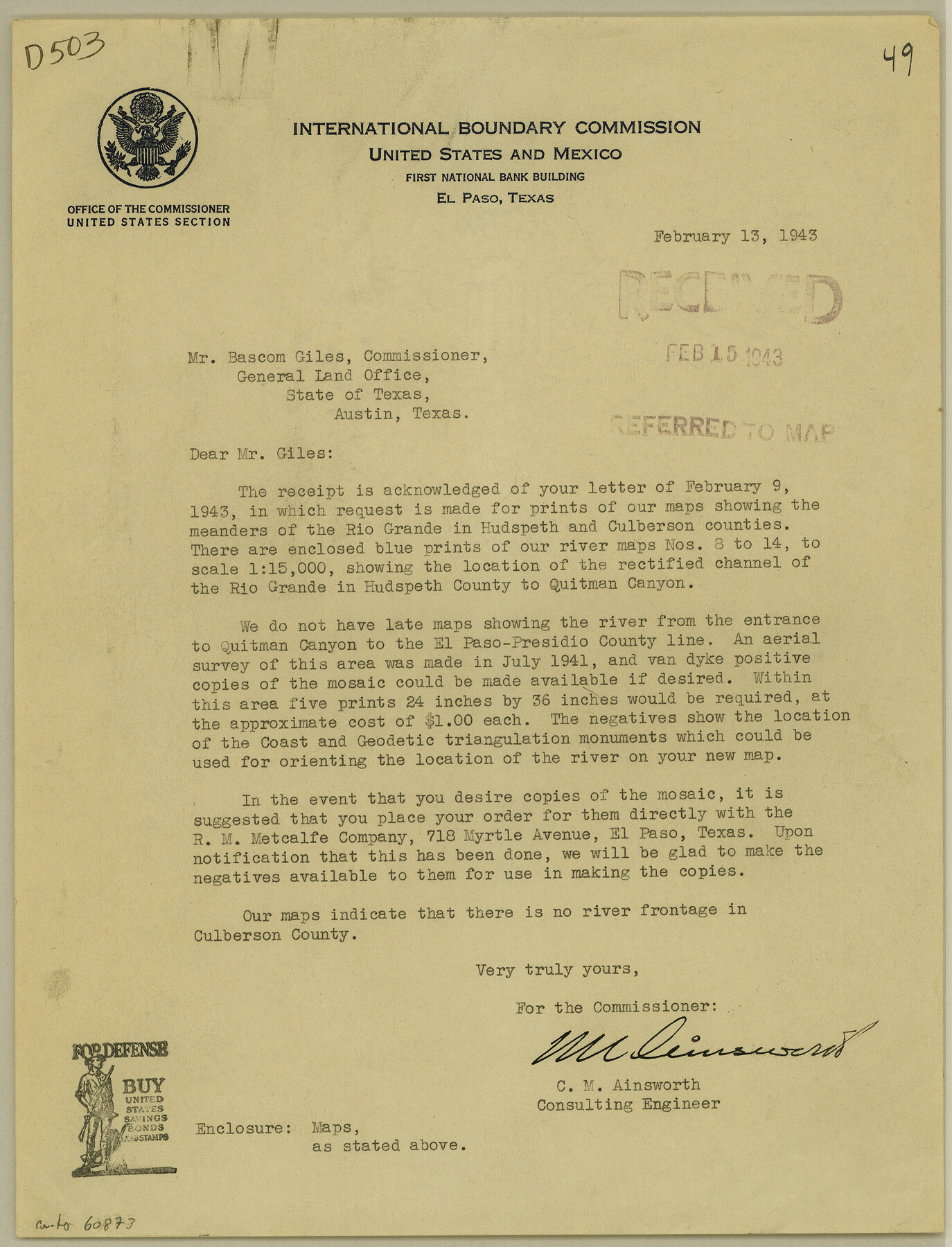
Rio Grande Rectification Project, El Paso and Juarez Valley
Rio Grande from El Paso-Hudspeth Co. line east to about Quitman Canyon
N-1-9
-
Map/Doc
60873
-
Collection
General Map Collection
-
Object Dates
1935 (Creation Date)
-
Subjects
River Surveys Texas Boundaries
-
Height x Width
10.8 x 8.2 inches
27.4 x 20.8 cm
Part of: General Map Collection
Clay County Working Sketch 13

Print $20.00
- Digital $50.00
Clay County Working Sketch 13
1955
Size 14.7 x 14.3 inches
Map/Doc 68036
Flight Mission No. BQR-5K, Frame 62, Brazoria County

Print $20.00
- Digital $50.00
Flight Mission No. BQR-5K, Frame 62, Brazoria County
1952
Size 18.9 x 22.6 inches
Map/Doc 84007
Van Zandt County Sketch File 16 1/2

Print $4.00
- Digital $50.00
Van Zandt County Sketch File 16 1/2
1858
Size 11.0 x 7.8 inches
Map/Doc 39414
Galveston County Sketch File 42

Print $20.00
- Digital $50.00
Galveston County Sketch File 42
1899
Size 23.9 x 23.7 inches
Map/Doc 11538
Texas, Brazos River, Freeport

Print $40.00
- Digital $50.00
Texas, Brazos River, Freeport
1933
Size 28.4 x 48.3 inches
Map/Doc 69994
Liberty County Working Sketch 51

Print $20.00
- Digital $50.00
Liberty County Working Sketch 51
1955
Size 17.5 x 38.5 inches
Map/Doc 70511
Red River County Working Sketch 74

Print $20.00
- Digital $50.00
Red River County Working Sketch 74
1980
Size 24.2 x 22.8 inches
Map/Doc 72057
Stephens County Sketch File 28

Print $14.00
- Digital $50.00
Stephens County Sketch File 28
1996
Size 14.2 x 8.6 inches
Map/Doc 37104
Concho County Working Sketch 20

Print $20.00
- Digital $50.00
Concho County Working Sketch 20
1957
Size 40.0 x 38.1 inches
Map/Doc 68202
Rusk County Sketch File 11

Print $4.00
Rusk County Sketch File 11
1849
Size 8.5 x 9.1 inches
Map/Doc 35509
San Patricio County Rolled Sketch 51

Print $40.00
- Digital $50.00
San Patricio County Rolled Sketch 51
1988
Size 41.8 x 54.6 inches
Map/Doc 10635
Schleicher County Sketch File 41

Print $6.00
- Digital $50.00
Schleicher County Sketch File 41
1963
Size 16.2 x 9.9 inches
Map/Doc 36544
You may also like
Marion County Rolled Sketch 9A

Print $20.00
- Digital $50.00
Marion County Rolled Sketch 9A
2001
Size 22.9 x 22.9 inches
Map/Doc 76419
Atascosa County Rolled Sketch 12

Print $40.00
- Digital $50.00
Atascosa County Rolled Sketch 12
1944
Size 33.3 x 68.8 inches
Map/Doc 8429
Reagan County

Print $40.00
- Digital $50.00
Reagan County
1915
Size 48.8 x 36.0 inches
Map/Doc 78429
Ward County Rolled Sketch 24F

Print $40.00
- Digital $50.00
Ward County Rolled Sketch 24F
1967
Size 43.0 x 72.4 inches
Map/Doc 10117
Flight Mission No. DCL-7C, Frame 9, Kenedy County

Print $20.00
- Digital $50.00
Flight Mission No. DCL-7C, Frame 9, Kenedy County
1943
Size 15.3 x 15.2 inches
Map/Doc 86001
Cliffside Situated on Section 21, Block 9, Potter County, Texas

Print $2.00
- Digital $50.00
Cliffside Situated on Section 21, Block 9, Potter County, Texas
Size 6.1 x 11.5 inches
Map/Doc 92100
Hood County Working Sketch 13

Print $20.00
- Digital $50.00
Hood County Working Sketch 13
1978
Size 27.6 x 24.5 inches
Map/Doc 66207

Galveston County Working Sketch 12

Print $20.00
- Digital $50.00
Galveston County Working Sketch 12
1967
Size 14.8 x 22.4 inches
Map/Doc 69349
Real County Working Sketch 74

Print $20.00
- Digital $50.00
Real County Working Sketch 74
1979
Size 17.1 x 23.5 inches
Map/Doc 71966
[Runnels County School Land and vicinity]
![91686, [Runnels County School Land and vicinity], Twichell Survey Records](https://historictexasmaps.com/wmedia_w700/maps/91686-1.tif.jpg)
Print $20.00
- Digital $50.00
[Runnels County School Land and vicinity]
1945
Size 17.9 x 12.5 inches
Map/Doc 91686
Cass County Sketch File 7

Print $4.00
- Digital $50.00
Cass County Sketch File 7
1853
Size 8.0 x 12.6 inches
Map/Doc 17408