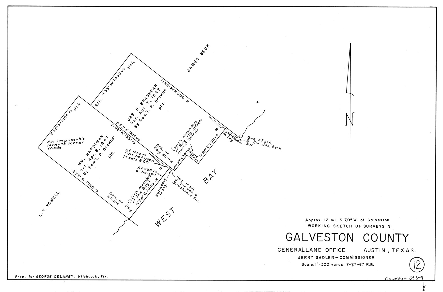
Galveston County Working Sketch 12
-
Map/Doc
69349
-
Collection
General Map Collection
-
Object Dates
7/27/1967 (Creation Date)
-
People and Organizations
Roy Buckholts (Draftsman)
-
Counties
Galveston
-
Subjects
Surveying Working Sketch
-
Height x Width
14.8 x 22.4 inches
37.6 x 56.9 cm
-
Scale
1" = 300 varas
Part of: General Map Collection
Parker County Working Sketch 12

Print $20.00
- Digital $50.00
Parker County Working Sketch 12
1974
Map/Doc 71462
Flight Mission No. CLL-3N, Frame 36, Willacy County

Print $20.00
- Digital $50.00
Flight Mission No. CLL-3N, Frame 36, Willacy County
1954
Size 18.4 x 22.2 inches
Map/Doc 87094
Grayson County Sketch File 16

Print $6.00
- Digital $50.00
Grayson County Sketch File 16
Size 11.3 x 8.4 inches
Map/Doc 24484
Foard County Working Sketch 1

Print $20.00
- Digital $50.00
Foard County Working Sketch 1
1899
Size 20.5 x 22.8 inches
Map/Doc 69191
East Portion of Matagorda Bay in Matagorda County, showing Subdivision for Mineral Development

Print $40.00
- Digital $50.00
East Portion of Matagorda Bay in Matagorda County, showing Subdivision for Mineral Development
1949
Size 30.8 x 51.1 inches
Map/Doc 1909
Flight Mission No. DQO-8K, Frame 49, Galveston County

Print $20.00
- Digital $50.00
Flight Mission No. DQO-8K, Frame 49, Galveston County
1952
Size 18.7 x 22.3 inches
Map/Doc 85156
La Salle County Rolled Sketch 6

Print $40.00
- Digital $50.00
La Salle County Rolled Sketch 6
1941
Size 43.0 x 66.0 inches
Map/Doc 10738
Zapata County Working Sketch 5

Print $20.00
- Digital $50.00
Zapata County Working Sketch 5
1940
Size 23.4 x 18.3 inches
Map/Doc 62056
Flight Mission No. DCL-7C, Frame 97, Kenedy County

Print $20.00
- Digital $50.00
Flight Mission No. DCL-7C, Frame 97, Kenedy County
1943
Size 15.3 x 15.2 inches
Map/Doc 86069
Franklin County Working Sketch 2

Print $20.00
- Digital $50.00
Franklin County Working Sketch 2
1953
Size 33.3 x 29.9 inches
Map/Doc 69240
Val Verde County Rolled Sketch 58

Print $20.00
- Digital $50.00
Val Verde County Rolled Sketch 58
1938
Size 17.9 x 22.4 inches
Map/Doc 8126
Flight Mission No. BRE-3P, Frame 95, Nueces County

Print $20.00
- Digital $50.00
Flight Mission No. BRE-3P, Frame 95, Nueces County
1956
Size 18.4 x 22.3 inches
Map/Doc 86826
You may also like
Bosque County Sketch File 34

Print $20.00
- Digital $50.00
Bosque County Sketch File 34
1856
Size 25.2 x 18.7 inches
Map/Doc 78486
Crane County Rolled Sketch 28

Print $40.00
- Digital $50.00
Crane County Rolled Sketch 28
2020
Size 35.7 x 51.2 inches
Map/Doc 96434
Stephens County Sketch File 3

Print $4.00
- Digital $50.00
Stephens County Sketch File 3
Size 8.6 x 10.6 inches
Map/Doc 37015
Chart of the Harbour of San [Luis]
![72761, Chart of the Harbour of San [Luis], General Map Collection](https://historictexasmaps.com/wmedia_w700/maps/72761.tif.jpg)
Print $20.00
- Digital $50.00
Chart of the Harbour of San [Luis]
1846
Size 27.3 x 18.3 inches
Map/Doc 72761
El Paso County Rolled Sketch 61

Print $20.00
- Digital $50.00
El Paso County Rolled Sketch 61
1994
Size 27.8 x 39.0 inches
Map/Doc 5853
Zavala County Sketch File 13

Print $4.00
- Digital $50.00
Zavala County Sketch File 13
1891
Size 14.5 x 9.0 inches
Map/Doc 41306
Flight Mission No. DQO-7K, Frame 99, Galveston County

Print $20.00
- Digital $50.00
Flight Mission No. DQO-7K, Frame 99, Galveston County
1952
Size 18.7 x 22.5 inches
Map/Doc 85114
Bird's Eye View of the City of Waco

Print $20.00
Bird's Eye View of the City of Waco
1873
Size 19.6 x 24.0 inches
Map/Doc 89211
[Surveying Sketch of Encibio Almaguie, T. W. N. G. R. R. Co., et al in Hutchinson County, Texas]
![93791, [Surveying Sketch of Encibio Almaguie, T. W. N. G. R. R. Co., et al in Hutchinson County, Texas], Maddox Collection](https://historictexasmaps.com/wmedia_w700/maps/93791.tif.jpg)
Print $20.00
- Digital $50.00
[Surveying Sketch of Encibio Almaguie, T. W. N. G. R. R. Co., et al in Hutchinson County, Texas]
Map/Doc 93791

Anderson County Rolled Sketch 14

Print $20.00
- Digital $50.00
Anderson County Rolled Sketch 14
1997
Size 30.1 x 36.5 inches
Map/Doc 77159
Freestone County Sketch File 9

Print $4.00
- Digital $50.00
Freestone County Sketch File 9
1859
Size 7.9 x 8.3 inches
Map/Doc 23056